blankblank blank


Archive for the 'coordinate conversion' Category Page 3 of 5


A Basic Raster Image GeoMetaData Extractor/Viewer

Many raster image formats commonly used in GIS applications have metadata embedded in them that georeferences the pixels (assigns them a coordinate location), and often includes other information like the coordinate system, origin, and datum. Some GIS programs will let you view some or all of this metadata, others won’t. I’ve written a simple GUI front-end program for the GDALInfo utility that will extract the metadata from a compatible image file, display it, and save it in a text file. Download the program folder here, and unzip it to your desired location; keep the executable and the GDAL subfolder in the same folder, otherwise the program won’t work. No installation required, just run the program. Choose the raster image file you want with the “Open File And Read MetaData” button:

Continue reading ‘A Basic Raster Image GeoMetaData Extractor/Viewer’


Easy Ways To Get Latitude/Longitude For A Screen Point In Google Earth

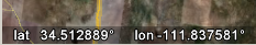
In the lower left-hand corner of Google Earth, there’s a latitude/longitude readout that shows the position at the cursor position:

9-21-2008-9.02.12 PM

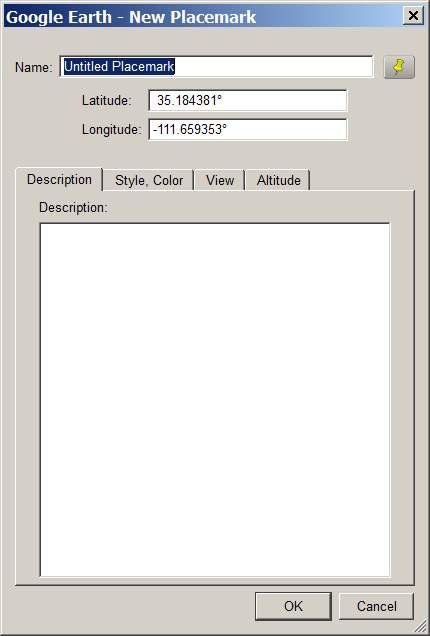
But if you want to record this position, the screen readout is graphical, so you can’t copy the numbers directly from Google Earth using a copy-and-paste operation; you have to write them out manually. One way around this is to create a placemark in Google Earth, and drag it to the desired location; the latitude and longitude will show up in the placemarks properties window, from which you can copy and paste them into a different app:

9-21-2008-9.06.51 PM

Another option is to use David Tryse’s Google Earth Position application. No installation, just run the program at the same time as Google Earth:

9-21-2008-9.15.26 PM

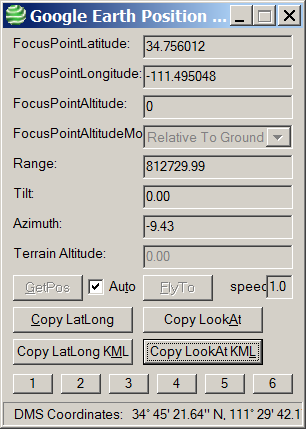
With Auto checked, it will update the position at the center of your Google Earth display continuously; unchecked, you’ll need to click the “GetPos” button to update the position. Clicking on the various “Copy” buttons copies position data into your clipboard for pasting into various programs:

Copy LatLong: 34.756012    -111.495048

Copy LookAt: 34.756012    -111.495048    0    812729.99    0.00    -9.43

Copy LatLong KML: <coordinates>-111.495048,34.756012,0</coordinates>

Copy LookAt KML: <LookAt>
<longitude>-111.495048</longitude>
<latitude>34.756012</latitude>
<altitude>0</altitude>
<range>812729.99</range>
<tilt>0.00</tilt>
<heading>-9.43</heading>
</LookAt>

With Auto unchecked, you can also enter a position into the Latitude and Longitude boxes at the top, and “FlyTo” that position in Google Earth. The numbered boxes at the bottom can save a current location (Shift-Click on the button), fly to a saved position (click on the button), or recall a saved position without flying to it (Alt-Click).

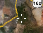
One big problem: there’s no center cursor or marker in Google Earth to indicate the center of the screen, so finding the position of a specific location might be difficultFixed in the latest version. But here’s a simple little KMZ file that puts a crosshair overlay at the center of the Google Earth screen, getting around this problem:

9-21-2008-9.24.55 PM

David’s website has several other apps worth a look. Google Earth Photo Tag lets you use Google Earth to embed location information into JPEG pictures (note: requires the Exiv2.exe command-line program in the same directory) . While I prefer Picasa for this task, GE Photo Tag does let you modify the balloon style for KML image files, which Picasa doesn’t. LatLong Conversion converts from degrees-minutes-seconds to decimal degrees and vice-versa, supporting more formats for the input data than other similar converters.


Free Surveying Software For Windows, Pocket PC And Palm

Martin Feuchtwanger of Underhill Geomatics writes of their surveying utility program Copan. I don’t know much about surveying, but can at least list some features from the help file:

  • COGO Calculations
  • Multiple Inverse Calculations
  • Field Data Processing
  • Field Azimuths Data Processing
  • Resection Processing
  • Map Traverses
  • Map Checks
  • Area and Perimeter Calculations
  • Coordinate Transformations
  • Traverse Processing
  • Azimuth Expressions
  • Distance or Offset Expressions
  • Shift Expressions
  • Point Renumbering or Replacement
  • Supports Geodimeter, Leica, Wild, Nikon and TDS total station formats
  • And more …Copan comes in versions for Windows:

    screen shot

    Palm:

    PALM_COGO5_sm

    And Pocket PC:

    PPC_TRAV1_sm

    Feature sets are similar between the different versions, and data can be interchanged between them; GPS is supported for the mobile platforms. The software is free, but you’ll need to get a password and license key via email to use any of the versions. The Windows license key is in a “.bin” file, and some email services (like GMail) won’t accept files with that extension.


  • Spreadsheet Tools For Lat/Long, MGRS and UTM Coordinate Conversions

    Cartisan Maps site is now dead (domain name grabbed by someone else); however, I have uploaded the two files to MediaFire, and updated the links to the spreadsheets to point to these files. There also may be problems running this in Excel, as it seems to want a password for some functions; however, it runs fine on the free Office clone LibreOffice..

    Cartisan Maps has several free spreadsheet tools for basic coordinate conversions; each one can handle up to 5000 sets of coordinates. Files are in Microsoft Excel format, but seem to work fine in OpenOffice 2.4.

    Cartisan Map Coordinate Converter: Enter latitude and longitude in separate columns for degrees, minutes and seconds, and have them converted to a DD MM SS string, DD MM.d string, or numeric decimal degrees. The first column, labeled Hemisphere, is multiplied times the longitude, and if you leave it blank, the calculated degree value for longitude will always be zero. Enter “1” for East longitudes, “-1” for West longitudes, and make sure your longitude degree value is always positive; or, enter a “1”, and then enter positive and negative values for the longitude degree value.

    Cartisan Total Map Coordinate Converter: Converts from decimal and DDMMSS latitude/longitude to UTM and MGRS, and back again; includes support for 14 datums, including NAD27 and WGS84. Also has another version of a converter from degrees/minutes/seconds to decimal degrees and back, similar in output to the one above.Requires that you have macros enabled in your spreadsheet program. Notes: 1. File is in the .RAR compression format; if your unzipping program can’t handle that, try 7-Zip. 2. Enter your coordinate data in the areas highlighted in green in the spreadsheet.


    Projection Parameters / Point-Of-Origin For State Plane Coordinate Systems (SPCS)

    In a comment on this post, Theron was looking for command-line solutions for converting from UTM to SPCS coordinates on a Unix system; I pointed him towards OGR and GeoTrans as possibilities, and he found that GeoTrans offered a solution. But he also discovered that finding the projection parameters for SPCS wasn’t as easy as he thought it would be. He did track down a few using Google, and was good enough to send them on to me:

    A simple, unorganized text listing

    Links to both a CSV-listing and an Excel spreadsheet

    To find the proper SPCS zone for your location, you can use the program described in the above-linked post, or try this website.


    Using The Demo Version Of Global Mapper As A Raster/Vector Data Viewer

    Global Mapper is a first-rate program for viewing and converting GIS data, raster (image and elevation) and vector. It opens over 100 different raster/vector formats, with on-the-fly support/display conversion of virtually every coordinate system / projection / datum you can think of, and some you might not (the Moon, Mars, the moons of Jupiter). It comes in a demo version with the following limitations (from the help file):

    • You will be unable to export data to any format.
    • You will be limited to loading a maximum of 4 data files at a time. With the full version, you can load any number of data files simultaneously.
    • No 3D capabilities (full version supports 3D views, viewsheds, line of sight, cut-and-fill volumen
    • You will be unable to load workspaces.
    • You will be unable to work with map catalogs.
    • You will be unable to download data from WMS map servers.
    • You will be unable to save rectified imagery to fully rectified files.
    • You will not be able to print to a specific scale (i.e. 1:1000).
    • You will have to endure a nagging registration dialog every time that you run the program.
    • You will not be eligible for free email support.

    There’s one more, which is you don’t have the option of printing/exporting the screen display as an image file (though you can still print to a printer what’s visible on screen; zoom in to get a higher-resolution printout). Global Mapper’s display options for vector objects are also more limited than a standard GIS data viewer (e.g. no coloring by attribute for shapefiles). For those two reason, the TatukGIS viewer may be a better choice, since it lets you export the data view, raster or vector, as a high-resolution georeferenced raster image. But TatukGIS Viewer only supports about 30-odd raster and vector file formats, and doesn’t do on-the-fly re-projection. For examining the occasional odd data format you run across, in unusual projections/coordinate systems, and making a quick print, Global Mapper is good to have in your toolbox.

    As a bonus, it also has a great line/area measurement function, which lets you modify the measurement units from metric to English and back on the fly, and copy them into the clipboard:

    gmmeasure

    The TatukGIS Viewer has a measure function, but it gives area only in the data’s native projection, less than useful if it’s in the geographic coordinate system (e.g. square degrees for area).

    Finally, if you’re looking for an all-purpose data format converter with batch conversion capabilities, don’t need the considerable power (or expense) of FME, and don’t want to deal with the GDAL command-line utilities, you could do far worse than the $299 fully-registered version of Global Mapper.


    AZ Garmin Topo Maps And More From The GPS File Depot

    Dan Bloomberg wrote to tell me of his new website, the GPS File Depot. Some useful stuff for GPS users, especially Garmin owners:


    Options For MGRS Coordinate Conversion And Viewing

    My visitation logs show a surprisingly large number of visitors interested in converters for the Military Grid Reference System (MGRS), the standard geocoordinate system used by members of the NATO Alliance. So I thought I’d do a quick roundup of previous links/posts related to MGRS, and then talk about another program that might be useful if you’re working in that coordinate system.

    Continue reading ‘Options For MGRS Coordinate Conversion And Viewing’