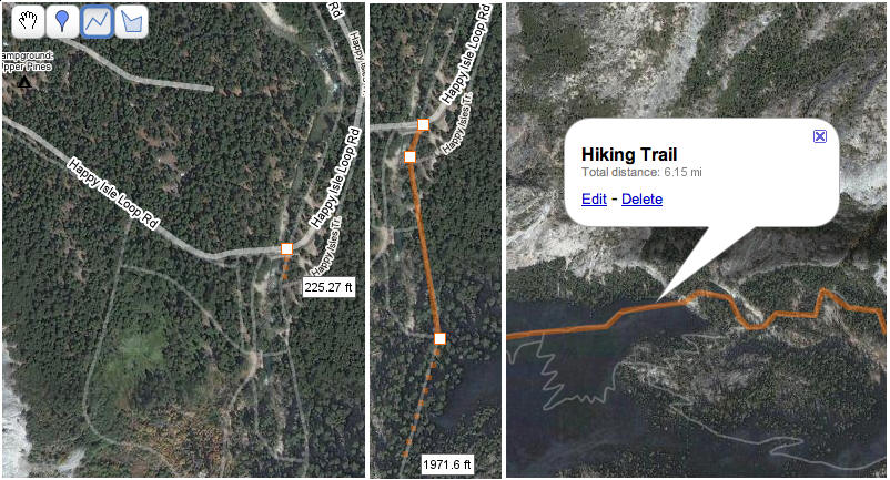
The official Google LatLong blog has announced that the Google Maps line tool in MyMaps now displays the total line length as you draw it, and also adds the line length to the pop-up info box for that line:
Exploring the world of free tools for GIS, GPS, Google Earth, neogeography, and more.


The official Google LatLong blog has announced that the Google Maps line tool in MyMaps now displays the total line length as you draw it, and also adds the line length to the pop-up info box for that line:
Slightly, but not completely, off-topic: I used to subscribe to the feeds for Engadget and Gizmodo, two blogs devoted to the latest and greatest in high-tech gizmos. But I dropped those feeds because:
So now I’m down to one gadget blog, and the one I highly recommend: Cool Tools from Kevin Kelly, one of the creators of Wired Magazine. Why do I like it?
Give Cool Tools a look; I think you’ll like it.
I’m also keeping my eye on a newcomer, BoingBoing Gadgets; perhaps a bit too techy for my tastes, but does branch out beyond the standard electronics stuff.
Note: Original website seems to have disappeared; I’ve uploaded a copy of the spreadsheet here.
I’ve posted before on several programs and websites that will convert spreadsheet point coordinate data (CSV or XLS) to Google Earth’s KML format (here and here). XLS2KML is another option, but it does a few things the others don’t:
– You can have additional data fields automatically appended to the Description section in the KML file
– You can automatically put points into folders and subfolders
– Columns labeled with case-insensitive KML descriptors (like Altitude, Range, Tilt, Heading, Icon, Time Start and End (for Timespan), etc. will have their data properly encoded in the proper KML format for that descriptor
– There are additional options for drawing paths, polygons and grids from this Excel spreadsheet, but they’re not well-documented with recently-added documentation. Still, you’d probably be better off converting line and polygon shapefiles into KML for the first two, or using GE-Path to create paths, polygons and grids, rather than doing it point by point with this method.
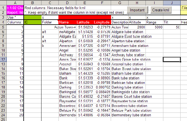
Download the spreadsheet from this site (see the link at the bottom). Click on the “Important” button near the top of the spreadsheet to get what little “Help” information come with this Excel macro-enabled spreadsheet.
Note: Garmin’s free BaseCamp software can now be used to view and install any mapsets, including non-Garmin ones; it’s not as good as MapSource, but it is free, and is also available for both PC and Mac. See this tutorial at the GPS File Depot for more info.
Most current Garmin GPS units come with a free version of MapSource, their software for uploading data/maps and downloading waypoints. tracks, routes, etc to and from Garmin GPS units. But if you’ve lost or misplaced your install disk, you’re out of luck; while Garmin has a downloadable updated version of MapSource on their website, it requires that you have the earlier version installed on your disk. Try and install it directly, and it will abort after telling you it can’t find a previous version.There’s a way around that “earlier version” limitation that lets those with a legitimate reason install MapSource on their computer. First, download and install a copy of Garmin’s free Training Center software, designed mainly for use with their fitness GPS units (ForeRunner and Edge). Once this software is installed, you can download and install the MapSource update file, and the full version of MapSource will be up and running on your computer (confirmed this on a system of my own).
Note: this will only have the MapSource base road data. If you have any additional map data you’ve purchased (like Topo, City Navigator, MetroGuide), you’ll need to re-install that from the original data disks. But since that process installs an original copy of MapSource on your computer, that makes the above irrelevant for you.
An alternate method is described here, but I haven’t tried it out myself.
What’s it good for? Well …
If you poke around this site, you’ll find other useful free GPS software that does some of what MapSource does, plus many things that MapSource doesn’t. Take a look in particular at postings in the categories for Garmin, GPS and GPX.
A previous post talked about sites where you could find, view and download high-resolution historical and modern maps. But there are also a number of worthwhile sites that, while not allowing high-res downloads, let you view historical maps online.
David Rumsey Map Collection: Probably the best-known online map site, with 15,800 maps viewable, including “antique atlas, globe, school geography, maritime chart, state, county, city, pocket, wall, children’s, and manuscript maps”. There are a number of different map browsing and viewing options, none of which I’ve ever been all that crazy about. Before you even think about using this site, make sure you set your browser and firewall to allow pop-ups from this site, otherwise you’ll go nuts. But once you get past those issues, there’s hours of map-browsing pleasure here.
British Library: Not surprisingly, very strong in historic maps, especially those of the British Isles and Europe. Check out the collections of scanned maps. Higher-resolution digital images of many of the maps are available for purchase.
New York Public Library: Large collection of online maps for NY, the US and the world, and (oddly enough) shaded relief military maps of the Austro-Hungarian empire. Prints available for sale.
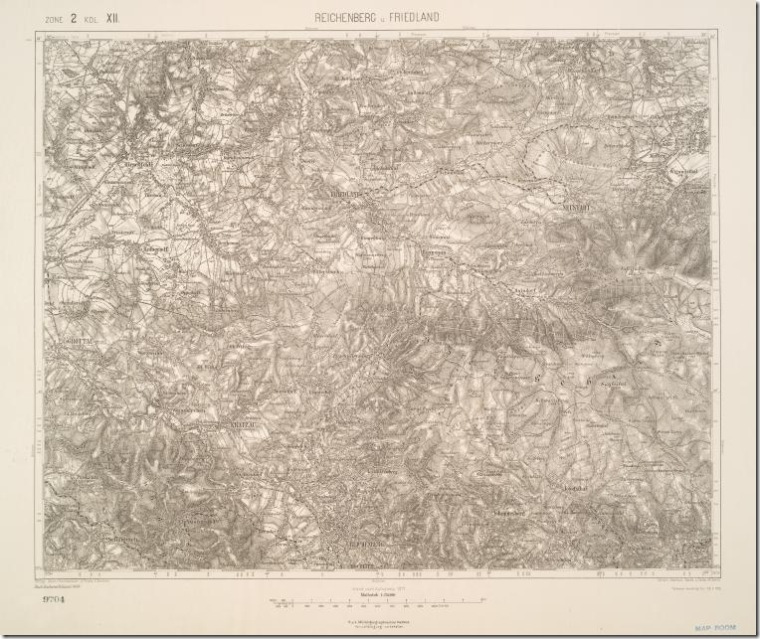
Shaded relief map of Reichenburg and Friedland, Austro-Hungarian Military Geography Institute
Know of any other large online map collections? Let me know in the Comments section.
There are a number of websites that have historic older maps available for online viewing (I’ll list a few of these in an upcoming post), but these sites typically don’t have the maps in high-resolution downloadable formats. You can always zoom in to the highest resolution, do a screen capture, then mosaic the images together if you have the time and patience. But there are a number of websites that do offer downloads of historic (and recent maps) in a high-resolution format. For some maps, a download link will be offered; for others, you’ll have to either right-click on a link to save the map to your computer, or open the image in your browser and then save it to your computer by right-clicking on the image.
Some maps are available in uncommon formats, like MRSid (*.sid), ECW (*.ecw) or JPEG2000 (*.jp2). If your graphics editor can’t open these formats, you can use the TatukGIS Viewer or IrfanView (with the additional plug-ins) to open these files and convert them to a more familiar format like TIF or JPG. Many maps are also available at the highest resolution in PDF format, and you can use a program like PDFCreator to convert them to standard image formats.
Library Of Congress: The US Library Of Congress has an enormous online collection of maps, historic and modern, for the US and the world, searchable and browsable by geographic area, keyword, subject, creator, and title. Most maps are downloadable in the MRSid format in very high resolution, but can also be viewed at various zoom levels online.
The Perry-Castaneda Map Library: Based at the University of Texas in Austin, this site offers modern and historical maps of the entire world at a wide variety of resolutions, mainly in JPG format but some in PDF as well. There’s also a large number of Texas maps (no surprise), and links to additional web map resources. I found the Army Map Service topographical maps of particular interest: 1:250K topo maps of many areas for which topo maps are difficult to find (Africa, Burma, Siberia, and more).
Leen Helmink: Website of a dealer in rare and antique maps, with high-resolution scans of historic maps from around the world, many for sale.
Yale University Map Library: A number of their historical and current maps are available for download in the JPEG2000 format (with more being added all the time).
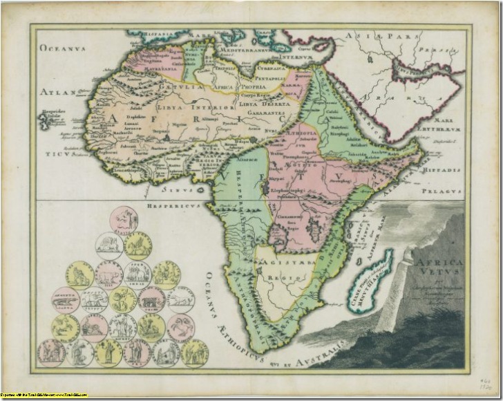
Africa map from Yale collection (resized 10x smaller than the original in pixel dimensions, 100x smaller in pixel area)
University Of Connecticut: Many historic maps, primarily of the New England and Mid-Atlantic region, most both viewable online and downloadable in MRSid format.
The Atlas Of Canada: Modern and historic maps of Canada, many (but not all) downloadable in JPG and PDF formats; check the bottom of the individual map pages to see if there are download links available. PDF maps are usually of higher quality than JPG.
Michigan State University: Primarily maps of Michigan, but some maps of Africa and North America.
Quebec National Library And Archives: In French, but you should be able to get around. Mainly maps of Canada and North America, browsable by titles (“titres”), authors (“autheurs”), by time (“chronologique”) and area (“toponyme”). Look for the link titled “la carte agrandie” to open the map image at full resolution in a new window, then right-click on the image to save it.
W. M. Keck Earth Sciences and Mining Research Information Center: Large selection of historic and modern maps of Nevada and surrounding areas.
Know of a good site that I’ve missed? Post it in the comments, and I’ll do a follow-up post later.
One of the quirks of Google Earth is that while you can draw a path between points as a feature using the “Add Path” toolbar button, or measure the individual and combined distances between points using the ruler (click on the “Show Ruler” button, then the “Path” tab), there’s no automatic way in Google Earth to determine the length of a path drawn using the “Add Path” button, short of tracing over it with the ruler. But there are several utilities that can take the KML file of a path and convert it into a distance. Two of them require you to to copy the KML path data into the clipboard (right-click on the path, and choose “Copy”), then paste it into the application. The third will accept data that way, but can also open a saved KML file to do the calculation.
4/26/09: GPStamper is now a commercial program; there’s a trial version that runs for 30 days, and free versions are available for non-commercial scientific work and surveys.
Geotagging a photo embeds geographic coordinates into the EXIF header, where it joins other information like the date and time the photo was taken. In a sense, Mike Lee’s GPStamper program does the opposite: it extracts the geographic coordinates from a geotagged photo, and makes a lossless copy of the photo with the geographic coordinates (and optionally the date and time) printed in yellow in the lower-right-hand corner of the photo.
Download GPStamper here, and install the program. You’ll also need to download EXIFTool for Windows, change the name of the exiftool(-k).exe file to exiftool.exe, and put it into the GPStamper program directory. Run the program:

Step 1 is to press the “Folder” button, and select a folder with geocoded photos in it. Then click on “PREPARE”, and the program will “prep” the EXIF header of the image files for stamping. Images are backed up automatically as a precaution; the backup has “_original” appended to the .JPG file extension, e.g. the original file “picture.jpg” will now be named “picture.jpg_original”.
Step 2, press the “File” button to select a photo to label with the coordinates, coordinates /date, or coordinates/date/time, depending on which of the options are chosen at the right. GPStamper doesn’t do batch labeling – you have to do one picture file at a time. When you press the “STAMP” button, GPStamper takes the JPG file and labels it as specified, leaving the rest of the image untouched and undegraded. It then saves the labeled photo with “-gps” appended to the filename, leaving the original as-is. So, for example, the original geocoded picture below, DSC00030.jpg …

… is labeled with coordinates/date/time in the lower right-hand corner, and saved as DSC00030-gps.jpg …
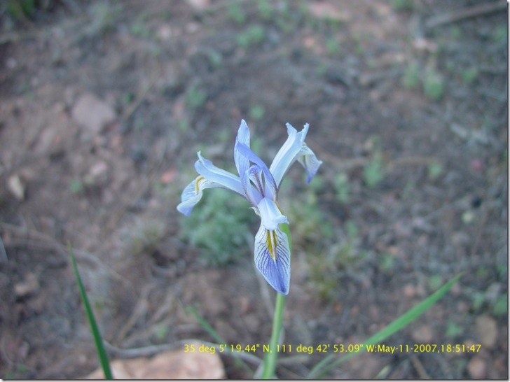
… but with the quality of the original image unaffected.
Mike has made the user interface as simple as possible, but welcomes user feedback on both the interface and the features. He also has a number of other useful image tools on his Lossless JPEG Toolbox website.
Edited 8/28/07 to indicate change in program: backing up original image files was originally an option, but is now done automatically by default.