A number of sites (e.g. the BBC) have recently posted about the TanDEM-X and TerraSAR-X program, which is generating a worldwide digital elevation model (DEM) database with a horizontal resolution of about 12 meters. A comparison is often made to the best current worldwide database, SRTM-90, which has a poorer 90-meter horizontal resolution and limited coverage at high north/south latitudes. What they don’t usually mention is:
- SRTM-90 data is available now; the TerraSAR-X dataset won’t be completed until 2014.
- SRTM-90 data is free, and freely available; the TerraSAR-X program is a public/private partnership, with Infoterra GmbH having exclusive commercial rights to the data. So if you want that higher-resolution data, you’ll almost certainly have to pay for it.
I’ve posted about sources for SRTM-90 data before; what I haven’t posted about is even higher-resolution data available from the ASTER GDEM program . This DEM dataset was “created by stereo-correlating the 1.3 million scene ASTER VNIR archive, covering the Earth’s land surface between 83N and 83S latitudes”. Further data processing was done to fill in voids and fix obvious data flaws. It’s currently freely available from two websites:
- NASA’s EOS Data Archive. The good news is that the data is here, along with a lot of other earth observation data. The bad news is that it’s a nightmare to find and download the data from this site.
- Japan’s ASTER GDEM website. Still not an optimal experience, but easier to figure out than the NASA site. You can download DEM data in GeoTiff format in one-degree-square chunks, up to 100 at a time. Free registration is required; use the “Search” link to access the data selection and download pages.
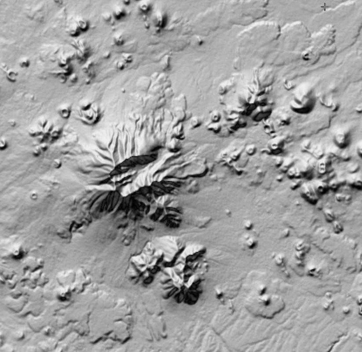
There’s a catch, though – while the GDEM data has a higher horizontal resolution than SRTM-90 data, it also has a lot more artifacts in it, even after being cleaned up. Here’s a SRTM-90 DEM image, 90-meter horizontal resolution:

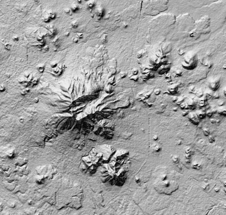
And here’s a GDEM image of the same area, 30-meter horizontal resolution:

“ASTER GDEM is a product of METI and NASA”
The improved resolution is obvious, but so is the increased “bumpiness” and other odd features in the GDEM data, artifacts of the data collection/reduction process. Contributing factors to the creation of these artifacts include cloud cover, vegetation type, land type, and man-made features (e.g. the linear feature running N/S in the image above is US Highway 89). There’s a Validation Report that goes into the reasons behind all these artifacts; their final conclusion is that the data should be treated as “experimental” or “research-grade”, but with the hope that future refinements might improve its qualities. If you can live with the resolution of the SRTM-90 data, that’s probably a better choice; but if your area of interest isn’t covered by SRTM-90, or if you absolutely need higher horizontal resolution and can live with the artifacts, ASTER GDEM could be a useful alternative.
Note: the original data of ASTER GDEM is the property of METI and NASA.
Having looked at GDEM in detail, and compared it to both SRTM and the NextMap samples available on the web, I think the only reason to use GDEM in preference to SRTM would be if you had Swiss Cheese SRTM, or if your area was poleward of the SRTM extents.
Compared to cartographic DEMs (NED or CDED) or the NextMap, the true resolution of the GDEM is about 3 arc seconds (which is also about the true resolution of the 1″ SRTM available in the US).
For anyone interested, I have a paper on this topic at the ASPRS meeting in Orlando next month with the detailed support for these generalizations.
You might be interested in some further links about SRTM vs ASTER vs Viewfinder:
– http://igorbrejc.net/openstreetmap/viewfinders-dem-data-comparison-with-srtm
– http://www.gravitystorm.co.uk/shine/archives/2010/01/13/aster-not-worth-it-yet/
I’ve been experimenting with the ASTER GDEM also. I created a Global version of the ASTER data at a 5 arc-second resolution that extends from 80 North Lat to 80 South Lat. I merged this data with the 3 arc-second version of the global SRTM elevation data. So the ASTER data fills holes in the SRTM data and extends the northern and southern extents an extra 20 degrees. I then added a 30 arc-second global bathymetry layer. Then to top it off, I applied the NASA Blue Marble image on top of the whole thing. The result is a 94 GIGA-pixel global terrain map that looks amazing.
I have lots of plans for this data and hope to figure out a way to make it available to the public. Right now, you can view it (at the full resolution) in Google Earth by following the link below.
http://bbs.keyhole.com/ubb/ubbthreads.php?ubb=showflat&Number=1373794#Post1373794
Further developments can be found at my blog.
http://www.gelib.com/terrain-maps.htm