5/2/2009: Apparently no longer available. Check out Microsoft’s new geotagging program, or the geotagging category at right for more option
A few years ago, Microsoft was promoting something called the World Wide Media Exchange, WMMX for short, a centralized index of photos tagged by geographic location – sort of a proto-Flickr. It got a bit of press, but seems to have faded into obscurity. But it’s left behind a few useful utilities, including a nice, simple photo geotagging utility called Location Stamper.
You can download WMMX Location Stamper from this link. Note that while you need to have Microsoft .NET 1.1 or higher installed, you probably already have that on our system. You don’t need the WMMX Client Application at all unless you want it – it’s the program that lets you upload and browse photos in the WMMX index, and create photo slideshows, but isn’t required for the Location Stamper or any of the other utilities on this page. Install Location Stamper, then run it.
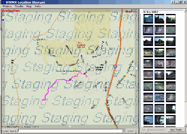
Not a lot of options, but it doesn’t need many. Add photos to be geotagged using the Photos => Add Photos menu, and they’ll show up as thumbnails on the right. Add your GPX track with the Tracks => Add Tracks menu, and the track will be loaded into the map window at left, along with an antique Microsoft MapPoint map for the area (it would be nice if they would update this with Virtual Earth, but I wouldn’t hold my breath). Click on the “Apply Tracks” button in the lower right, and the location/time data from the GPX track will be matched with the timestamp on the photo to geotag it. Select a photo that’s been geotagged, and a circle will appear on the track in the map window to show its location.
You can also geotag photos by zooming in to a location in the map window (click on the blue globe in the upper left to bring up a map if nothing is showing, or enter a location in the search box at the bottom), and then dragging a photo to a location on the map. But the map quality is so poor, it isn’t all that useful an option here – you’d be better off using Picasa with Google Earth for this kind of tagging.
Photos geotagged by Location Stamper appear to have fully-legitimate EXIF geographic tags, but as with locr, Picasa doesn’t seem to be able to recognize those tags. But EXIFTool, along with my utility, can modify the header so that Picasa does recognize the geotags.
As long as you’re checking out WMMX Location Stamper, you might take a look at some of the other utilities you can download from the WMMX page. The WMMX Travelogue Authoring Tool lets you create a geographic web page with your geotagged photos, maps, text and GPX tracks. If you download and install the full WMMX Client, you can create photo slideshows with maps and pop-ups that can be converted into files for viewing with the stand-alone WMMX Story Viewer.


I’ve enjoyed reading your series on Geotagging tools and was wondered if WWMX Location Stamper (not WMMX) would be covered. I’ve tried all sorts of different tools and I invariably return to this tool.
Here are the features that keep bringing me back:
* GPX tracks (and location of located photos) are displayed on top of an actual MAP so you can easily see if things are lining up correctly.
* Simple way to adjust photo timestamps
* Recognizes already geotagged photos
* Automatically creates backups of your photos before it stamps the location info (or when adjusting the time stamps)
I can’t seem to find other tools that combine these basic tools as nicely as WWMX.
And for anyone having trouble loading their Garmin GPX files into WWMX, I’ve found that editing the tag so that it references version 1.0 instead of 1.1 allows the GPX to work in WWMX.
Change this:
to this:
I had a feeling it would ditch my example. Hopefully this will get the point across..
Change this tag:
gpx xmlns=”http://www.topografix.com/GPX/1/1″ creator=”MapSource 6.5″ version=”1.1″ xmlns:xsi=”http://www.w3.org/2001/XMLSchema-instance” xsi:schemaLocation=”http://www.topografix.com/GPX/1/1 http://www.topografix.com/GPX/1/1/gpx.xsd”
to this:
gpx xmlns=”http://www.topografix.com/GPX/1/0″ creator=”MapSource 6.5″ version=”1.0″ xmlns:xsi=”http://www.w3.org/2001/XMLSchema-instance” xsi:schemaLocation=”http://www.topografix.com/GPX/1/0 http://www.topografix.com/GPX/1/0/gpx.xsd“
I have been reading your series about Geo Tagging with interest. My question is about tagging images that are collected at a rate of 4 or more frames per second. Typically Geo Tagging software uses the windows file creation or modification time stamp which is to the nearest second and my image collection times are in milliseconds. Is there any Geo Tagging software out there that will read 2 files (image name and time; and GPS track) and interpret the location of each image between the GPS positions (taken every second) on either side of the image capture times?
Or can I edit my image times to include fractions of a second and use tools you have presented thus far?
A quick look at several of the applications I’ve covered indicate that they only let you set the time a whole second, not a fraction of a second. So you may be out of luck.