blankblank blank


Archive for the 'KML' Category Page 8 of 16


Two Online Vector GIS/GPS/KML Conversion Utilities

GeoConverter: GeoConverter is an online front-end for ogr2ogr which lets you convert a limited number of vector file formats to each other. Free registration is required; while the registration page is currently in German the registration page is now available in English. Formats supported are:

  • Comma Separated Value (.csv/(.csvt))
  • GPX (.gpx)
  • Geographic Markup Language (.gml)
  • INTERLIS 1-Transfer Format (.itf/.ili)
  • INTERLIS 2-XML Transfer Format (.xml/.ili)
  • Keyhole Markup Language (.kml) (write-only)
  • MapInfo File (.mif/.mid)
  • Shapefile (.shp/.dbf/.shx)

You can convert to/from any of these formats except for KML, which is write-only currently. Formats with multiple files (e.g. shapefiles with .shp, .shx and .dbf files) require that all files to be upload are zipped up into a single file (100 MB max). I suspect the conversion system is Unix-based, which is usually happier with files that have no spaces in their filenames. Also worth remembering that certain formats like GPX and KML require the coordinates to be lat/long WGS84, so you’ll have to make sure your source data is in that coordinate system. I converted a fairly complex polygon shapefile into a KML file successfully, with the attributes written into the KML polygon properties, but there’s no ability to modify display based on attribute properties, as with shp2kml or Shape2Earth.

Thanks to Professor Stefan Keller, one of the creators of this utility, for the tip.

D2M Converter: 5/2/2009: May be dead. A new online utility from Data2Map, currently in beta; free registration required. Converts from any of these formats:

  • Access
  • Excel
  • MS SQL
  • ASCII
  • MapInfo (.mif)
  • ESRI shapefile (.shp)

to either Microsoft MapPoint (.ptm) or Google Earth (KML).

A few notes:

  • You have to create a “Conversion Definition” label, or bring up an saved one, for every conversion
  • For data formats like shapefile or MapInfo with multiple files, you have to upload every datafile (e.g. shp, shx, dbf for shapefiles).
  • 10 MB / 10,000 record limit.
  • You need to select one of the attributes with a unique value for each record as the “ID”.
  • You can clip out data by geographical bounds, and also to a limited degree by attribute values.
  • There are limited abilities to use filters assign colors/pushpin images based on point attributes, and they’re working to add more capabilities. But for now, line/polygon KML files have one color for all shapes.

The service is still in beta, so it may have some quirks, but Data2Map has been very responsive to any issues I’ve encountered.
Online Spreadsheet To KML Converter

Bill Clark, the author of the useful Google Earth Public Land Survey System (PLSS) tool, has a new online app for converting spreadsheet data into point KML files, and opening them directly in Google Earth. Spreadsheet files can be in XLS (Office 2003 or earlier for now, Office 2007 support coming), CSV, or TXT (tab-delimited format); the minimum data required includes only latitude and longitude (either decimal or degree-minute-second formats are acceptable). Optional additional data accepted includes:

  • Name for each point
  • Description (text for pop-up balloon)
  • Icon (use the table on the web app page to select a number corresponding to the desired icon graphic)
  • Formatting tags (size and color of icon, altitude, connecting lines)

Make sure the column headings are included, exactly as specified on the web page’s instructions; there’s an option on the web page to review the spreadsheet data online to make sure it’s correct. The data is formatted into KML at the server, then sent back to your computer to be opened in Google Earth; the original data is then deleted at the server end for security. If you want to save the data displayed in Google Earth, make sure you right-click on the data item in the Places window on the left, and save it in either KML or KMZ format.


Full Index Of 1:250K US Army Topographic Maps

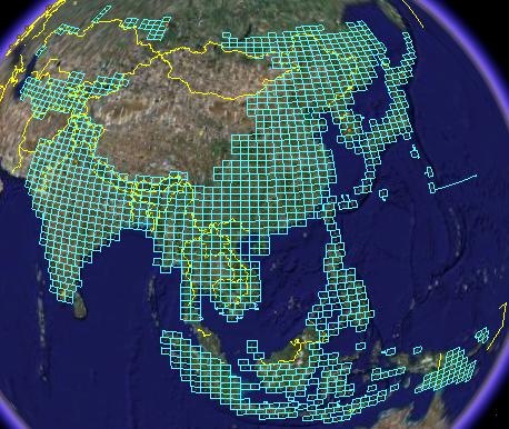
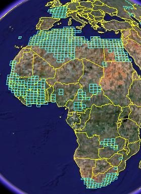
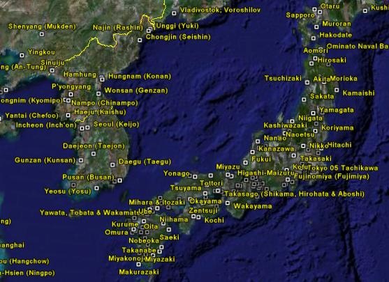
An earlier post featured a Google Earth KML file by Price Collins that indexed US Army topographic maps (1:250K) downloadable from the Perry-Castaneda Map library. At that time, 435 city maps and 413 1:250K quadrangles had been indexed, with each indexed map reference in the KML file containing a download link to the original map graphic file. Price writes to say that he has finished the index; it now includes 1785 topo quadrangles, covering large parts of Asia, Oceania, and Africa:

2rcr49y

5fnjew

Also, 440 city maps; this picture shows those available for part of East Asia

2ci7l7n


Most Recent MODIS Imagery In Google Earth

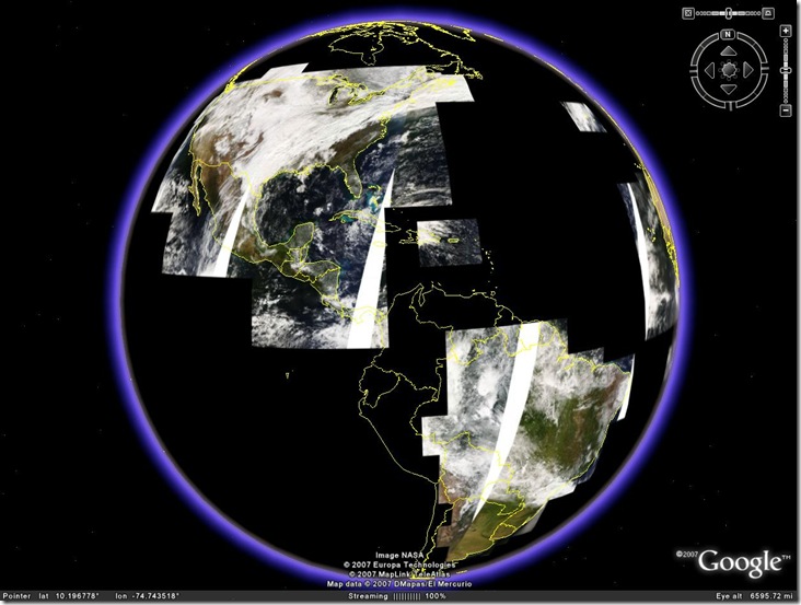
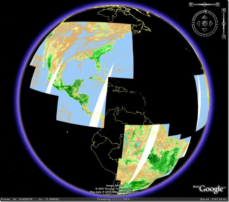
OgleEarth posts about a new KML layer for Google Earth, available from NASA’s OnEarth website, that displays the most recent day’s MODIS (Moderate Resolution Imaging Spectroradiometer) imagery as a Google Earth overlay. Separate overlays from both the Terra and Aqua satellites include:

  • Real-color imagery

modisrealtime

  • Pseudo-color (Blue, green and infrared bands)
  • NDVI (Normalized Differential Vegetation Index), where the greenest area have the highest vegetation level

modisndvi

Even with two satellites, Terra and Aqua, MODIS images don’t cover the entire planet over the course of a single day. But over several days you’re likely to see the most up-to-date publicly-available satellite imagery of the surface of our planet. MODIS’s resolution is 250 meters, so don’t except to see whether your car is parked in your driveway on a particular day :).

Other sources of MODIS imagery:


Text Editor With KML Validation

Google has a video tutorial on how to set up the free Java text editor jEdit so that it will automatically validate KML as you type it in. Given how picky KML is about cases (capital letters) compared to HTML, this is a nice capability to have for both creating and debugging KML files. Now if someone would only create a KML plugin for jEdit …

The Google Outreach page has other great Google Earth tutorials:


Creating GPS Routes And Tracks In Google Earth

EarthNC has a new Google Earth tool for taking points, paths, and polygons created in Google Earth, and either converting them to GPX or uploading them directly to a Garmin GPS (Windows only for the latter). Points are converted to points, paths to routes, and polygons to tracks. The downloadable KML file, full text instructions, and a demonstration video, are available at the website. They also have a simple online tool for converting KML files directly to GPX format by copying the KML file into the online text box and clicking a conversion button.

Via Ogle Earth.


Creating Google Earth Screen Overlays With EarthPaint

Last week, I covered my KML Screen Overlay Maker utility, which simplifies the job of converting graphics into Google Earth screen overlays. It occurred to me that this utility could be used in conjunction with the free utility EarthPaint to create screen overlays. I’ve covered EarthPaint before – it’s a useful tool for creating Google Earth ground overlay files using vector-graphic-like drawing tools (lines, circles, ellipses, polygons, text, etc.). But the graphic file it generates can be used along with the KML Screen Overlay Maker to create a screen overlay instead of a ground overlay.

1. Start up EarthPaint; Google Earth will start up at the same time.

2. You’ll be given the option to either use the current location in Google Earth, or set a new one. Doesn’t matter which one you choose, since you’ll be creating a fixed screen overlay.

3. EarthPaint will load in a black-and-white image of the current view in Google Earth. Use this image as a guide as you draw the elements you want in your screen overlay, with the edges of the image defining the limits of the screen overlay graphic. There’s more info on this in my original EarthPaint post.

4. When done, click on Create => Send to Google Earth. You’ll be asked to enter a name for the overlay graphic; after clicking OK, the graphic image you created in step 3 will be opened in Google Earth as a ground overlay. It’s a GIF file with transparency, which makes it perfect for creating a screen overlay.

5. Go to the program directory for EarthPaint (default is C:\Program Files\EarthPlot Software\EarthPaint. Open the “Cache” subdirectory, and look for a GIF file that has the name assigned in step 4. Copy this GIF file to another location.

6. Start up the KML Screen Overlay Maker, and select the GIF graphic file from step 5.

7. Leave the Overlay Size units, x and y, as fraction, and enter “1” for the value of both of those. This will automatically resize the overlay graphic to fit to the edges of the view in Google Earth. Leave everything else as is.

8. Save the file, and then open it up in Google Earth (with the Network Link option in KML Screen Overlay Maker if you want). You should now see the graphic image created in step 3 as a screen overlay that doesn’t move as you change the view in Google Earth.


KML Circle Generator

Site appears to be down; try theĀ GE Path program as an alternative.

KML-Circles is an online app that creates open or filled polygons around a specified center point. With the default number of 60 vertices, you essentially create circles, but by selecting a small number, you can create other polygons (e.g. 3 for a triangle, 4 for a square), but with no control over their orientation. It operates in two different styles:

Continue reading ‘KML Circle Generator’