blankblank blank


Archive for the 'Garmin' Category Page 7 of 13


Curing Garmin Blue Flag Waypoint Disease

I’ve been asked this question twice already, which is good enough for me to write a post about it. If you use any of the color Garmin eTrex or GPSMap series, you’ll quickly discover that the default waypoint symbol, a blue flag, is pretty useless. It takes up a huge amount of screen space, and if you have multiple waypoints spaced closely together, it can become impossible to differentiate them. This is especially when the display is zoomed out to a lower scale:
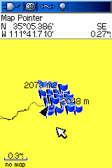
blueflagdisease

There are a number of ways to deal with this problem.

1. Set the waypoints zoom level so that they don’t appear until you’ve zoom in.

The default setting for waypoints to display is Auto, which usually means that they’ll show up at virtually every zoom level. But you can set a specific zoom level so that waypoints don’t appear until you reach that zoom. From Setup Map – Points:
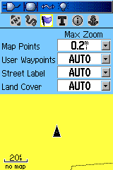
autowaypoints

Change the User Waypoints setting to the desired zoom level at which waypoints will first appear. E.g., the 800-ft. zoom:
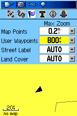
800ftzoom

Since you’re zoomed in closer to the waypoints when they show up, they’ll be spaced more widely. But if you actually want them visible when zoomed out to a lower scale, you’ll need to do something else.

2. Change the default waypoint symbol on the Garmin unit to something smaller.

When you create a new waypoint on your Garmin, the waypoint icon used is the same as the last one used. If you’ve never changed the waypoint icon, that will be a blue flag. You can change the waypoint icon in the waypoint creation screen by moving the yellow highlight box using the arrow keys:
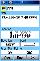
waypointhighlight

Then press Enter, and choose a smaller icon:
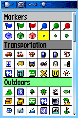
smallicon

I like the small green dot because it takes up far less display space than just about any other symbol. But you can choose any icon you want; or see my series on creating custom Garmin waypoint symbols if you want to design your own. Once you’ve selected a new waypoint symbol, it will be used for all subsequent waypoints you create on your Garmin.

3. Use MapSource to modify the waypoint icons.

Unfortunately, there’s no way on your Garmin GPS unit to bulk convert waypoint icon symbols created on your Garmin; you have to edit them on the unit one at a time. But if Garmin’s MapSource program (aka Trip and Waypoint Manager) came with your GPS or with a mapset you’ve purchased, you can easily do a symbol conversion, either one at a time or in bulk.

a. Use MapSource to download the waypoints from your GPS.

b. Click on the Waypoints tab to bring up a list of waypoints
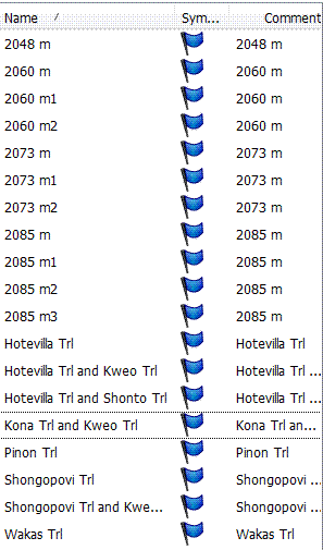
Waypoint list

c. To change the icon for a single waypoint, right-click on the waypoint in the list and choose Waypoint properties; or, from the map, right-click on a waypoint and choose Waypoint Properties. This brings up a dialog box with a icon symbol selection drop-down:
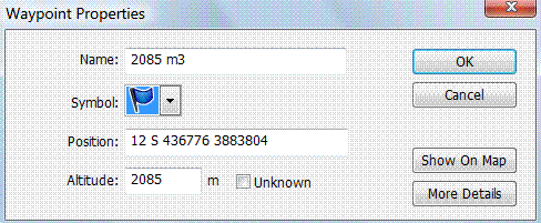
waypointproperties

d. To change the symbol for multiple waypoints, Ctrl-click on them in the Waypoint list; to select all the waypoints, click in the Waypoint list and then press Ctrl-A. Then right-click on any selected waypoint, and choose a symbol; your choice will be applied to all the waypoints. You can then save these waypoints in a file, or export them directly back to your GPS. For the latter, you might want first to delete the old waypoints with the undesired symbol; Garmin unit give you the option in the Waypoints listing screen to delete all waypoints that share the same symbol.

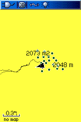
Having done this with the waypoints in the first image, converting them to green dots:
greendots

You can now differentiate different waypoints, where before they were a mass of indistinguishable blue flags.

This is also a useful technique to use when creating waypoints in a program that doesn’t support Garmin waypoint icons directly, like USAPhotoMaps; loading waypoints directly from a program like this into a Garmin GPS may result in Blue Flag Disease. Create the waypoints in this program, then save them as a GPX file and load them into MapSource. You can then use the above process to select your desired waypoint icons, and load them into the GPS.

4. Use GPS TrackMaker to modity the waypoint icons

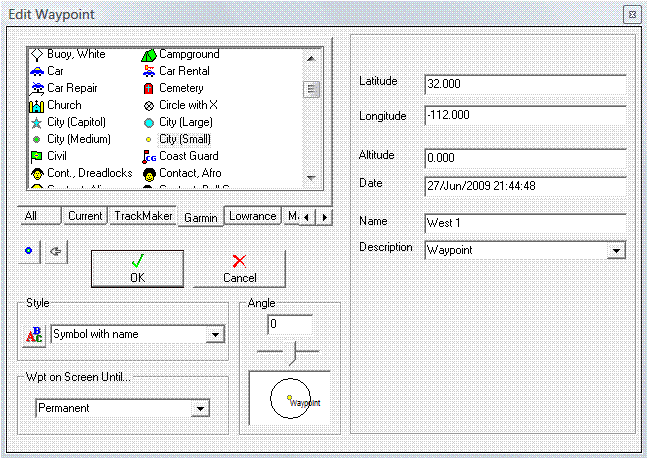
If you don’t own MapSource, you can use the free program GPS Trackmaker to import waypoints from a Garmin, or from a GPX file, and then modify they waypoint icons. One at a time is easy – with the cursor in “Select data” mode (white arrow), move the cursor to near the waypoint until a black circle appears. Right-click on that black circle to bring up the Edit Waypoint window:
gpstm edit

Click on the Garmin tab to see only Garmin-compatible symbols, then choose a new symbol from the icons visible in the window. You can then upload the icons directly to your Garmin from the GPS menu, or save them as a GPX file.

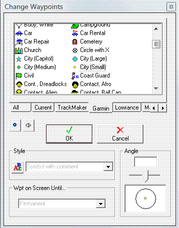
Bulk conversion is also pretty easy. Use the Select data cursor to select all of the waypoints you want to change (click-and-drag to select a rectangular box). From the menu at top, select Tools => Waypoints =>  Change Selected Wpts … . A window similar to the one above will come up:
gpstm bulk

As before, choose the Garmin tab, then select the icon you want to use. Save it as a GPX file, or upload directly to your Garmin.
Automating Your Garmin Oregon Photo Geotagging Flow Using GeoHarvest

There are a number of stand-alone Windows apps and web apps that led you geotag photos by matching the time they were taken with points on a GPS track (see the geotagging category of this blog for examples). But all of them require you to start up the program, load in the photos, load in the GPS track, and then start up the geotagging process. Flip Fahrenfort geotags a lot of his photos, and got tired of the multiple steps involved. So he wrote GeoHarvest, a program that automates the process to a large degree for owners of Oregon Garmin GPS units. When a memory card or camera is attached to your computer, it can automatically download a copy of digital photos from a memory card/camera to a folder of your choice, and keeps track of the photo filenames. When you connect a GPS, it will download track data and save it in GPX format. It then matches up the track times with the times the photos were taken, and geotags the photos with the appropriate coordinates.

The program can run continuously on your system, monitoring for all inserted memory cards or attached cameras with images to download, or GPS units with tracks to download as well. But if you want it to run this way, you’ll have to copy a shortcut to the program to your Startup folder manually, since the program doesn’t come with an install program that does that. It also can run in single-transfer mode, so that you can connect the data sources, have the photos geotagged automatically, then have the program terminate.

Unfortunately, since I don’t own a Garmin Oregon unit, I was unable to figure out how well it works with that unit. And while the program option suggest that you should be able to get the program to work with other GPS models with some manual work, I was repeatedly unsuccessful at this – GeoHarvest refused to accept GPX files generated by multiple programs. There are online help pages on program configuration and usage; if you can get it to work with your non-Oregon GPS, please leave a comment below.


Garmin BaseCamp Released

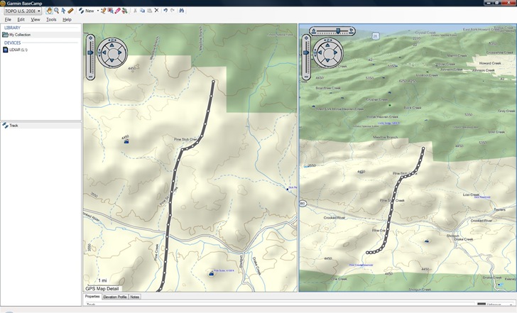
If you own a Garmin mapset that includes DEM data, like their 1:24K topographic mapsets or Topo US 2008, you might want to download and take a look at Garmin’s new free 3D map viewer and GPS data editor, BaseCamp. Here’s a screenshot using Topo US 2008 data:

3-30-2009-11.10.29 PM

On the plus side:

  • 2D/3D/Overview map views
  • Elevation profiles along a track
  • Photo geotagging using a GPS track
  • Some advanced editing features, like a track split function and eraser

On the down side:

  • Program is slooooow, even on my fairly recent quad-core system
  • Default 3D view is too subtle, even with decent topography; go to the options section and change the elevation exaggeration to something more useable, like 200%.

It’s probably worth downloading if you have a compatible mapset, but I don’t find the new features compelling enough to make me switch over from Garmin’s older Mapsource program to BaseCamp, especially given how sluggish the latter is. Hopefully future versions will be snappier, and add more features.


Lots More 1:24K-Equivalent Garmin Topo Maps Now Available

Since my last update on free 1:24K-equivalent topo maps for Garmin GPS units from GPSFileDepot, there’s been a huge explosion in the number of states covered:

  • Southeast US: Covering all of Alabama, Florida, Georgia, Mississippi, North Carolina, South Carolina, and Tennessee; parts of Arkansas, Kentucky, Louisiana, Missouri, and Virginia
  • South-Central US: All of New Mexico, Oklahoma, and Texas; parts of Arkansas, Louisiana, and Missouri
  • Southwest US: Covering all of Arizona, parts of CA, UT, and NV
  • Illinois: The entire state
  • New England: A combination of mapsets previously available separately for MA, ME, VT, NH
  • Montana Landowner Topo: The whole state, with special colors identifying landowners
  • New Jersey: Entire state
  • New York: Entire state
  • Ohio: Entire state
  • Washington: Entire state
  • West Virginia: Entire state

Windows installers available for all, Mac for many. Part of the reason for this flurry of activity may be that Dan Bloomberg, webmaster for the site and creator of most of the older maps, has released a new tool called Topo Process that simplifies the process of obtaining and processing the data necessary to create these topo maps. While the official Garmin 1:24K topo maps have more features, like elevation profiles, routing, and shading in supported units, much more of the US is covered by these free maps than is currently available from Garmin. And you can’t beat the price.

In addition to the topo maps, a browse through the Custom Maps directory will bring up lots of other specialty maps and data, like trails, POIs, and even raster maps for a few areas like Joshua Tree National Park.


Splitting A GPX Track Into Smaller Files

Some GPS models, such as most Garmin handheld units, allow you to record up to 10,000 points as the active track. But if you save an active track with more than 500 points, the unit will automatically simplify the track to a maximum of 500 points, dropping what it considers to be redundant or unnecessary points; you have no control over which points get dropped by the unit. One option is to simplify the track yourself with GPS Trackmaker’s Tracklog Reducer, which also drops points but gives you some control over the degree of simplification. But if you absolutely have to preserve all the points, there’s another option; GPX Track Splitter lets you chop a track with more than 500 points into a set of smaller tracks that come in under this limit, but which preserve all the points.

Continue reading ‘Splitting A GPX Track Into Smaller Files’


Garmin Topo Maps For Afghanistan, Baghdad

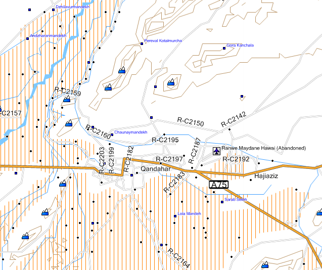
Just noticed on the GPSFileDepot site that they’ve started posting 20-ft.-contour topographic maps for Afghanistan for Garmin GPS units, created by Steakhouse Studio. Here’s a MapSource screenshot of the Kandahar area:

Garmin topo map of Afghanistan

Twenty-five topo maps are currently available, covering one-by-one or one-by-two degree quadrangles; by my best estimate, this covers roughly a half of Aghanistan’s territory, but it looks like new maps are being added on a regular basis. The link page also include road maps for Afghanistan as a whole, and for metro Kabul.

Also at GPSFileDepot is a Garmin topo map for the Baghdad, Iraq area, with 20-ft. countours, roads and points of interest. Plus, there’s a permanent download page for the routable Garmin map of Baghdad mentioned in an earlier post.

Windows and Mac installers available for all these mapsets.

Addendum (5/22/2009): An upgraded set of these maps is available for US Government use only; contact the author for info.


Downloading MapQuest, Live Search Results To A Garmin GPS

A while ago, I covered the process of downloading a Google Maps search result to a Garmin GPS, using the Garmin communicator plugin. The Garmin blog has posted videos on how to do the same thing with Microsoft Live Search:

MapQuest:


and Google Maps as well:


You will need to have downloaded and installed the Garmin Communicator plugin first; versions are available for both PC and Mac.


Breaking Up A Garmin gmapsupp.img Map File Into Separate Map Tiles

Yesterday’s post was about CloudMade, a website where you can download Garmin map files based on OpenStreetMap data for any country in the world that has OSM data. But all the map tiles for a country or state are combined into a single gmapsupp.img file, which means you can’t install the tiles into Garmin’s MapSource program. Because of this limitation, you can’t combine them with other mapsets and upload them to your Garmin GPS using MapSource. But there’s a simple way to break that gmapsupp.img file into the component subtiles, which can then be installed into MapSource, and uploaded with other mapsets.

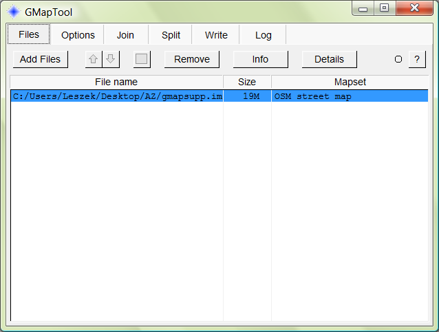
First, download the program gmaptool, and unzip it into the directory of your choice; this used to be a command-line utility, but now comes in a handy GUI format that drives the command line tool gmt.exe. Next, start up the program, navigate to the directory that contains the gmapsupp.img, and open the file:

gmaptool GUI

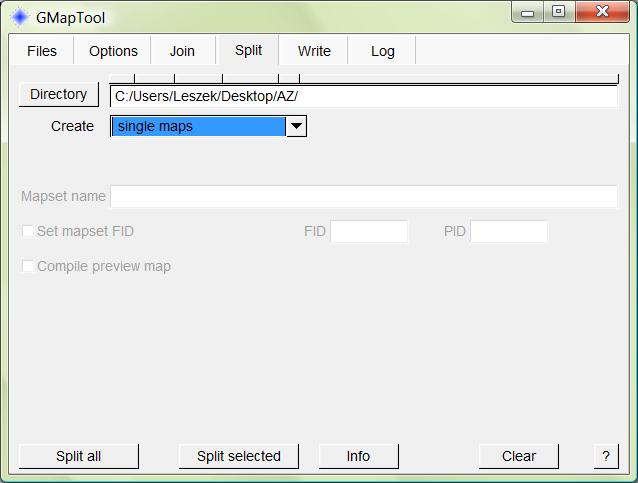
Click on the Split tab, select the directory you want to put the tiles in, and select “single maps” from the dropdown:

11-9-2008-9.11.34 PM

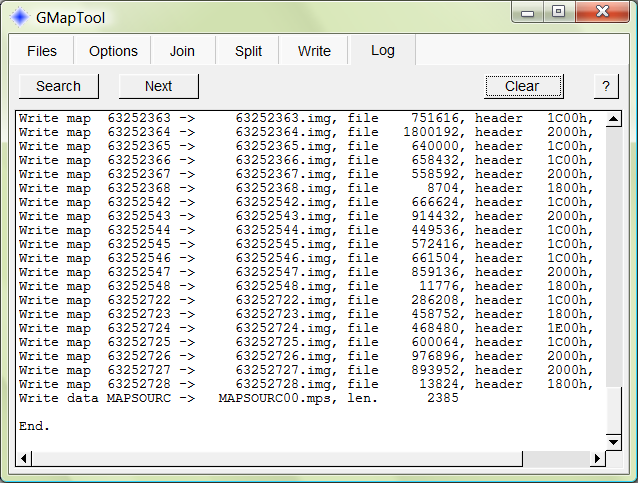
Click on the “Split all” button, and the subtiles contained with the gmapsupp.img file will be extracted, and listed in a status window:

11-9-2008-9.13.54 PM

You can now use a program like MapSet Toolkit to install the tiles for viewing in MapSource, and uploading individually or combined with other mapsets into your Garmin GPS:

11-9-2008-9.15.17 PM

Note: The dropdown on the “Split” tab includes the option for creating files for installing the tiles directly into MapSource, but it doesn’t seem to be working right now. Running the install.bat file gives an error message saying that the needed program cgpsmapper can’t be found, and specifying the path for this file under the Options tab doesn’t solve the problem. I suspect this will work at some point in the future.

The command line program gmt.exe driven by the GMapTool GUI contains many additional advanced functions for handling Garmin map files, not all of which are currently accessible using the GUI, including removing/changing unlock codes (no, this won’t let you pirate Garmin mapsets), making maps transparent, and more. Check the readme.txt file that comes with the program for more info; there’s also a “gmaptool_en.html” help file with more info on the GMapTool GUI.