blankblank blank


Archive for the 'coordinate conversion' Category Page 5 of 5


Handy Online Lookup Of EPSG Coordinate System Codes

The European Petroleum Survey Group (EPSG; now defunct, and superseded by the OGP Surveying and Positioning Committee) created and maintains a spatial reference database, assigning EPSG code numbers to spatial reference systems (combinations of coordinate systems, projections, and datums). There really is no way to figure out the spatial reference system from just the code number alone, or vice versa, so you need to look them up. The official database is in Microsoft Access format, not terribly easy to use; the code list in tabular format isn’t much better. There’s now a convenient online version of the database, searchable by keywords or code number. You can then access additional information for that spatial reference system in a number of different formats:

  • Human-Readable OGC WKT
  • Proj4
  • OGC WKT
  • JSON
  • GML
  • ESRI WKT
  • USGS
  • MapServer Mapfile
  • PostGIS spatial_ref_sys INSERT statement

Users can also upload their own spatial reference definitions, which I suppose is a good thing as long as you exercise caution in using them.

Via import cartography.


Fast Lookup Of The State Plane Coordinate System ID For Any US County

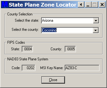
The State Plane Coordinate System (SPCS) is a projected coordinate system that achieves greater accuracy than UTM by dividing states up into sub-zones based on county, and then uses a local projection in that sub-zone (typically Transverse Mercator for zones that are oriented more north-south, and Lambert Conformal Conic for those that run more east-west). Keeping track of which county goes with which zone for every state can be a pain. The State Plane Zone Locator is a free utility that makes looking up the state plane system for any county easy. Oddly enough, the program installation doesn’t put any shortcuts into the Start Menu or on the Desktop, but the default install directory for the program is “C:\Program Files\MentorSoftwareCO\CountyLookup\”, and the executable is “CountyLookup.exe”‘. Run the program, and use the drop-down selections to choose the state and county you’re interested in:

Look up SPCS zone for any state in US

The State Plane system ID info (NAD83 only) will show up at the bottom, in this example AZ83-C (AZ Central, NAD83). You also get the state and county Federal Information Processing Standards (FIPS) codes.


Using UTM Coordinates In Google Earth

Google Earth’s native coordinate system is geographic (latitude/longitude, WGS84). So if you have your coordinates in UTM (Universal Transverse Mercator), you need to convert them to geographic first before using them in Google Earth. There’s a small utility that makes using UTM coordinates in Google Earth a lot easier.

UTMFlyer allows you to enter UTM coordinates, and go directly to that point in Google Earth. No installation program, just unzip it into a folder. If it complains about missing .bpl files, you can download them here, and put them either into the same folder as the program or the Windows/System32 folder. Start up the program; if Google Earth isn’t running it will be started up automatically as well. Basic interface is very simple:

Interface for UTMFlyer for using UTM coordinates in Google Earth

Choose the UTM zone and hemisphere (N or S) with the dropdowns, and the UTM coordinates, Easting and Northing separated by a comma. When valid coordinates are entered, the airplane logo will appear at the right – click on that, and Google Earth will go to that location.

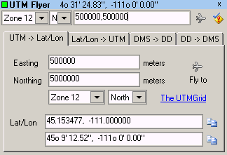
But wait, there’s more. The checkmark/exclamation icon is a dropdown menu. In addition to links to the software home page, an info page on UTM, and setting the altitude you fly to, there are also links to “Conversion” and “Extent”. Select Conversion, and the program window expands and adds several option tabs:

Interface for UTMFlyer for using UTM coordinates in Google Earth

Here, you can enter UTM coordinates and convert them to latitude/longitude (WGS84 only), or do the opposite conversion; clicking on the airplane icon will once again take you to that location. And there’s a bonus decimal degree to degree-minute-second converter (and back again).

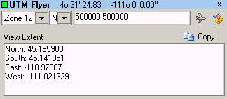
Selecting “Extent” from the menu gives you this window:

Interface for UTMFlyer for using UTM coordinates in Google Earth

Which shows you the extents of the current view in Google Earth in geographic coordinates.


Coordinate Converters III – Two Freeware Converters

Two previous posts talked about the coordinate converters CorpsCon and GeoTrans. Both are very good, but are large in filesize, and not necessarily user-friendly. There are two other freeware coordinate converters that are smaller in download size (1.7 MB and 0.9 MB), and fairly easy to use for single point conversions.

Continue reading ‘Coordinate Converters III – Two Freeware Converters’


Coordinate Converters II – Worldwide Coordinate Conversion

CorpsCon is the one coordinate converter to use if you’re only interested in NAD datum and coordinate conversions in the US. But since it only covers the US, only NAD, and only a limited number of coordinate systems (geographic, SPCS, UTM and NGRS), another free coordinate converter is needed for the rest of the world.

Continue reading ‘Coordinate Converters II – Worldwide Coordinate Conversion’


Coordinate Converters I – NAD Conversions

I’ve posted before about how to convert shapefiles from one coordinate system/datum to another. But I sometimes have the need to convert individual coordinate points, or text files with sets of coordinate points, from one coordinate system and/or datum to another. This post is the first in a series on freeware coordinate converters.

Continue reading ‘Coordinate Converters I – NAD Conversions’


A Free And Easy Shapefile Coordinate Converter

Shapefiles can be created in any coordinate system, and are often (and annoyingly) found in a coordinate system different than the one you’d like them to be in. For example, several of the shapefile to KML converters posted about recently require that the shapefile be in Google Earth’s native coordinate system: geographic coordinates (latitude/longitude), WGS84 datum; what do you do if your shapefile is in a different coordinate system, like UTM, Lambert Conformal Conic, or State Plane Coordinate System? There are lots of free conversion utilities out there that can reproject shapefiles from one coordinate system/datum to another, but there’s one I prefer because it’s fast and easy to use.

Continue reading ‘A Free And Easy Shapefile Coordinate Converter’