I love rocks. I love dirt. And I love the maps that show them. A good geology map is visually like a weird hybrid between a Peter Max poster and Jackson Pollock drip painting, but also tells a story spanning several billion years of Earth’s history. I’ve found a few websites where you can find and download geology maps in a variety of formats.
The National Geologic Map Database, run by the United States Geological Survey, catalogues maps and geologic names, and also describes what mapping is currently underway. Clicking on the “Geoscience Map Catalog” is a portal to info sections describing over 75,000 maps of United States geology from over 350 sources. Many of these info sections only give general metadata about the maps and where you can obtain them, but many others offer links to either the maps themselves in PDF or online MRSID format, or the actual GIS data information itself.You can search by Place Name, pull up statewide maps from a graphic interface, or search by general criteria. There used to be a graphic interface showing which detailed maps were available for different areas of the country, which was very handy; unfortunately, they’ve removed that graphic interface, with a general comment to the effect that “we’re working on a new one”. Still, after you select a place name, you’re given a wide variety of options to narrow down your search by:

Here’s a screenshot of an online geology map accessed through this website, just south of Barstow, California:

For geology mapping of the US and the rest of the world, try the Interactive Mapping Tool at Cornell’s Geoscience Information System pages. You won’t get the same kind of detailed maps as you can at the USGS site, and the mapping interface is a little clunky, but it does offer data for the rest of the world, and you have the option of downloading the amps you create in JPEG or PostScript format.
And when rocks die, they become dirt. The US Department of Agriculture’s Soil Data Mart offers downloads of soil data for the entire United States. Mapping at the small-scale state level is complete (STATSGO), while larger-scale mapping with greater detail is in the process of being completed (SSURGO). Map data can be downloaded in GIS format, or created in a browser using the Web Soil Survey site, though the latter limits you to areas less than 10,000 acres in size and isn’t very convenient to use. The USDA also offers a free Soil Data Viewer which can be used as an extension to ArcMap to link soil GIS data to tabular soil data and create soil-based thematic maps, but which can also be used as a stand-alone in conjunction with Microsoft Access to extract tabular data.
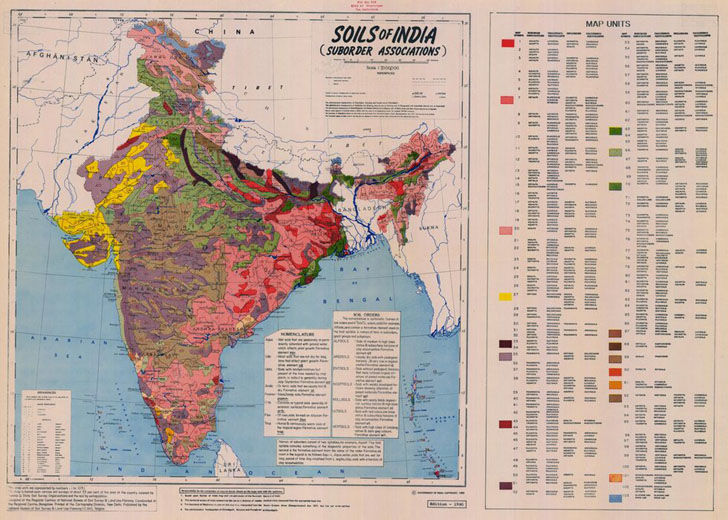
For the rest of the world, the European Digital Archive On Soil Maps Of The World has a large selection of digitized paper soil maps covering virtually every country, most of which can be downloaded in JPEG format. Here’s a sample map of the soils of India (a higher-resolution version can be downloaded from the website):

I’ve been subscribed to you for a few weeks, but with a non-descriptive title like that and no summary to go on, I’m gonna have to move on. G/L.
I’m sorry you feel that way, but truthfully I don’t understand.
1. The first paragraph of the post clearly states that it’s a post about geology, and specifically about geology data websites. That paragraph made it through my blog reader (Google) without any problems, and PlanetGS as well, and I’m assuming it made it through to yours fully intact. What did I leave out?
2. If you’re unsubscribing on the basis of just one single post whose title you didn’t like, unsubscribing would likely make sense even if this post hadn’t appeared. If you haven’t gotten anything of value from my other posts, then subscribing is probably a waste of your time. I honestly don’t mind; I drop blog subscriptions all the time, for a variety of reasons, and I suppose yours is as good as any. G/L back at you.
Hi Leszek. I enjoy reading over your blog from time to time, as I too am always looking for good FOSS tools. I am a soil scientist at UC Davis and the title of this post caught my attention.
We had developed an alternative interface to the USDA-NCSS STATSGO and SSURGO data for 3 western states: CA, AZ, and NV. Although we are currently in the process of updating our imagery holdings, the website is available at:
http://casoilresource.lawr.ucdavis.edu/drupal/node/27
This application allows one to explore and query the STATSGO and SSURGO databases within the context of other sources of GIS data. If you have any questions or feedback we are always interested.
Also, you may find our collection of FOSS tools and examples of general interest:
http://casoilresource.lawr.ucdavis.edu/drupal/node/95
Keep up the good work!
Cheers,
Dylan Beaudette
Dylan,
Thanks for the latest dirt :). Nice work on that interface – far easier to use than the USDA one.
Dirt Rocks! So does the title. Great post, thanks for the info.
Thanks. I did find that some blog readers might only be offering the title, and not the summary. Given that, I can see the first poster’s point – “Rocks and Dirt” alone doesn’t really convey any useful information. I’m going to try to fix that issue ….
Thanks for that, I just discovered you blog, and it has been quite eyeopening..
For Australian soil data viewing, there is an ARCIMS server http://www.asris.csiro.au.. You used to be able to extract the vector files from it, but it has been disabled in the last 6 months. There might be away to extract it some other way- I duno
no geological data for areas outside US (india for e.g.)
There are in National Geologic Map Database data for Canada?
No Canada data in this database, but geology data for Canada is available here:
http://gsc.nrcan.gc.ca/map/index_e.php