Standard terrain visualization programs like MicroDEM or 3DEM typically give you the option of viewing terrain either from top down:

Or from an oblique angle, looking in one direction:
Continue reading ‘Varying-Angle Terrain Views With Terrain Bender’
I’ve covered the program 3DEM before on this blog; it’s a first-rate 3D terrain visualization program, and does the best out-of-the-box map relief shading of any free program I know. Here’s a standard USGS topo shaded with a digital elevation model using this program:

Unfortunately, the author, Richard Horne, has ceased development of the program, and shut down the website permanently. But he’s graciously given me permission to host the last version of the program (version 20.7) here on Free Geography Tools; you can download it here. It comes with a full PDF manual, and my posts may offer additional insight on using it. I can offer some limited help if you run into problems, but any bugs in the software are there to stay.
In a previous post, I gave a random overview of LandSerf’s strong terrain analysis functionality. But it has some some useful vector functions as well, some derived from or related to raster elevation data, others more general. I won’t talk about the general vector data creation functions here; they’re perfectly fine, but lots of free GIS program can do that; instead, I’ll just highlight a few of the more distinctive vector functions that aren’t as common. Note: Save the derived vector data if you want to keep it; LandSerf doesn’t save created, modified or derived datasets automatically.
Continue reading ‘LandSerf – Vector Functions’
I’ve been waiting for LandSerf 2.3 to officially come out of beta before posting on it, and that finally happened about a month ago. LandSerf is a Java-based GIS program with:
- Terrain visualization and analysis functions (its primary focus)
- Some vector functionality related to terrain analysis, plus other basic vector functions
- GPS and Google Earth utilities
Today, I’ll walk through some of LandSerf’s basic terrain visualization and analysis functions; upcoming posts will deal with the vector and GPS/Google Earth capabilities.
Continue reading ‘LandSerf – Terrain Visualization And Analysis For Windows, Mac And Linux’
A bit of a departure from the usual posts, since this service is definitely not free. I just purchased a solid 3D landscape model from LandPrint.com and thought I’d review the creation process and the results, offer my opinion, and give some tips for getting the best results if you order your own.
LandPrint lets you select a square/rectangular section of the Earth’s terrain, and creates a small 3D model of that terrain along with your choice of overlays:
Continue reading ‘Solid 3D Landscape Models From LandPrint’
YP asks:
…would you know an easy (and free) way to query a DEM (Digital Elevation Model) to get elevations for a list of points (potentially as many as a few thousand)
Well, I know one way to do it with free software:
Continue reading ‘Get DEM Elevations For A List Of Points’
I’ve posted before about Digipoint (version 1 and version 2), a web app that lets you select points in a Google Maps interface, then export their coordinates in a variety of formats. Version 3 of Digipoint is now out, with some modest improvements:
- A new interface, a bit easier to use, and which works better in browsers where the default font size has been modified
- Fly-to: Specify an address, country, or location, and the map will automatically go there. There are also a limited number of pre-specified country/region links, where clicking on the link takes you to the area automatically
- In previous versions, you had to copy/paste text for a particular export format like CSV or KML; you can now download the file automatically
- For exported shapefiles, a corresponding prj file is also created to specify the coordinate system (your choice of geographic or UTM; WGS84)
- Help section added
Still supports the same export formats as before: CSV, TXT, TAB, BLN (Surfer), GPX, KML, DXF and shapefile. Versions one and two are still available if you want them, but there’s no good reason to use them anymore.
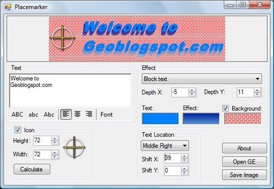
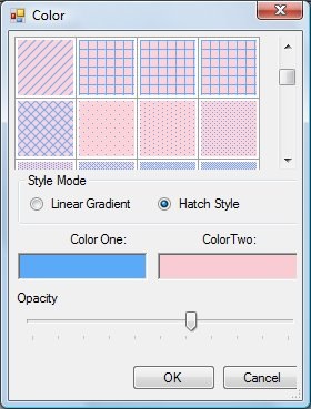
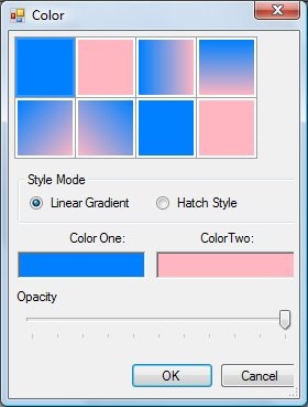
Placemarker, a custom placemark creator for Google Earth, was covered on this blog a few weeks ago. Valery Hronusov, one of its authors, writes to say that additional features have been added, and it’s pretty much complete. The new features include the options for linear gradient, crosshatch and custom backgrounds: