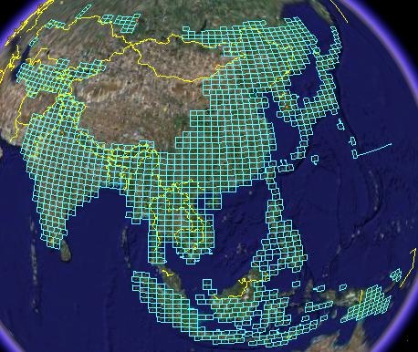
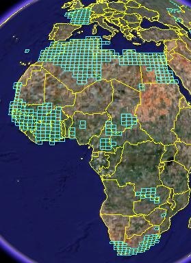
An earlier post featured a Google Earth KML file by Price Collins that indexed US Army topographic maps (1:250K) downloadable from the Perry-Castaneda Map library. At that time, 435 city maps and 413 1:250K quadrangles had been indexed, with each indexed map reference in the KML file containing a download link to the original map graphic file. Price writes to say that he has finished the index; it now includes 1785 topo quadrangles, covering large parts of Asia, Oceania, and Africa:


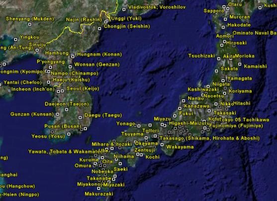
Also, 440 city maps; this picture shows those available for part of East Asia

Other posts in the Topographic Maps series
- Free Soviet Military Topographic Maps Of Europe And Asia
- Updated USGS 24K Topographic Maps From The US Forest Service
- Identify And Download USGS 24K Topographic Maps In Google Earth
- Mexican National Atlas
- The USGS Seamless Data Distribution System
- Topographic Maps, Satellite Photos And Vector Data For Israel And Jordan
- Free Digital Geographic Data For Canada
- Google Earth Library Now Open
- Google Maps With A Topographic Overlay
- News About “Hey What’s That” Panorama And Viewshed Site
- Two Google Mapplets From The “Hey What’s That” Site
- Free 10-Meter UTM SDTS 24K DEMs
- USAPhotoMaps: Additional Capabilities
- Downloading USGS Topo Maps In GeoPDF Format, And The GeoPDF Plug-In
- Downloadable US Bathymetric And Fishing Maps
- Full Index Of 1:250K US Army Topographic Maps
- Downloadable Updated NOAA Raster Navigation Charts
- Reproject NOAA BSB Raster Navigation Charts And Export Them In TIFF Format
- Topographic Map Symbols for Historic Topographic Maps
- List Of Map Products From the USGS
- New GeoPDF Features


0 Responses to “Full Index Of 1:250K US Army Topographic Maps”