If you regularly work with bearing and distance from a coordinate position, you might find Forward/Inverse from Mentor Software a useful tool. Just enter the starting position (latitude/longitude), the bearing and distance to the destination, click Calculate, and get the coordinates of the destination:
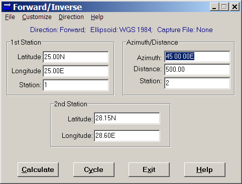
In this example, the distance is in kilometers, and the bearing in degrees, but you can customize those units: degrees or grads for angle, and a full range of English and metric units for distance. You have the choice of 26 different ellipsoids, and a selectable lat/long format (decimal degrees, DM, DMS).
You can also capture the results in a text file, useful if you have a list of them to calculate. The Cycle option is especially useful in such a case, as it puts the destination coordinates (2nd Station) automatically into the origin coordinates (1st Station). So, you can continually input azimuths and distances, calculate the next destination, make that the new “1st Station” with the Cycle button, and capture all the data for all points in a text file. Finally, if you choose “Inverse” under the Direction menu, you can calculate the azimuth and distance from the 1st station to the second one.