I’ve posted before about absolute positional accuracy issues in Google Earth. The Google Earth coordinates corresponding to a feature on the earth can be off from the true coordinates of the feature, about 30 feet in my neck of the woods. With the new Google Maps “My Maps” feature, I was curious as to whether you get any improvement in positional accuracy using Google Maps to create KML files for a point, rather than using Google Earth directly.
First, I created a point in Google Earth at a highway intersection:

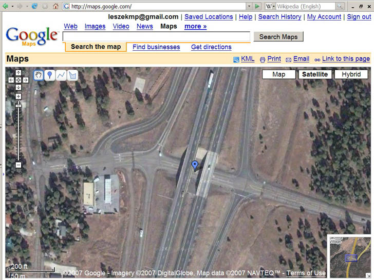
Next, I created a point at the same location in Google Maps “My Maps”:

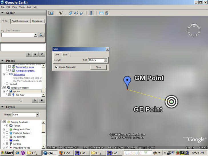
Exporting the Google Maps point as a KML file, bringing it in to Google Earth, enlarging the view, and measuring the difference between the two:

GM point is from Google Maps, GE Point from Google Earth. There’s a slight differential in the two, about 2.5 meters, but that’s almost certainly due to my inability to position the points exactly in the right location in both images, i.e. I’m a klutz. So coordinates match up reasonably well between Google Earth and Google Maps.
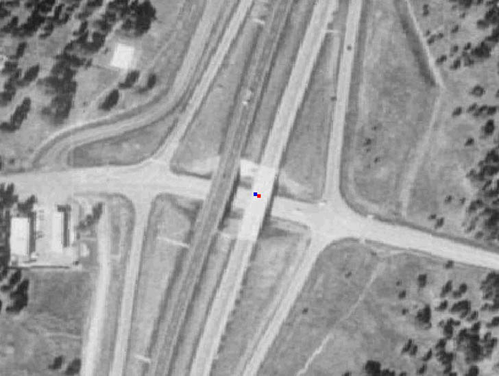
But if I plot these points on top of a georeferenced USGS aerial photo:

with blue being the Google Maps point, and red the Google Earth point, you can see they’re displaced from the actual position by about 10 meters, or a bit more than 30 feet. That’s comparable in size and direction to what I saw in my previous post on Google Earth accuracy. So you’ll get consistency if you export data from Google Maps “My Maps” to Google Earth, but the coordinates you get in the Google Maps KML file can still be off from the true values. It wouldn’t surprise me if the magnitude and the direction of the shift varied from place to place; if you’re hoping to use either Google Maps or Google Earth for determining positions with high accuracy, you should definitely do a ground check first to see what degree of coordinate shift there may be in your area.
Note: If you have info about the Google Earth or Google Maps coordinate shift for your area, please post it in the comments section below (location and size of shift).
The problem with your comparison is that the USGS DOQQ’s have a up to a 33.3 foot error. You would need some survey grade points to truly compare.
http://nationalmap.gov/digitalbackyard/doqbkyd.html
You do realize the the USGS photo might be using a different datum (possibly NAD27) than Google Earth (which is WGS84, effectively the same as NAD83)?
The imagery in Google Earth is stretched based on the angle of the aerial object taking it. Further, the 3D terrain of Google Earth is low resolution, so the imagery can shift depending on the inaccuracy of the terrain. (You might want to try turning off the terrain and making comparisons). To make matters worse, Google has not described in detail how it goes about registering imagery. Human factors are probably involved in alignment and especially in stitching together images for esthetic appearance sake.
The key point is that Google Earth is NOT a GIS or survey-grade dataset. They don’t promise to be, and they discourage its use for those types of applications.
Anonymous: The doc you reference refers to published maps in paper format (check the date of the PDF spec). The stated error comes when you try to make measurements on a printed paper copy of the photo – your capability to mark a position on the map is limited by its size, and your ability to measure distances by hand. That’s not the case for a digitized orthophoto, since the measurements are done by the computer. On a computer, the resolution is essentially limited to how far I can blow up the image, the pixel size, and how klutzy I am in positioning the cursor.
xenonofarcticus – The DOQQ started out life in NAD83 UTM 12, and was re-projected with Global Mapper to WGS84 geographic coordinates. If it were NAD27, it would have been *way* off (about 212 meters in my area).
Frank – Tried turning the terrain off, and repeating the process. Absolutely no difference whatsoever. Not surprising, since the terrain is fairly flat here.
Correction for terrain variation is a standard part of orthorectifying an aerial or satellite image, so I wouldn’t think that would make that much of a difference. With satellite images, for most of the earth, it’s not even going to be that much of an issue, since the height of the satellite (around 300 miles) will be that much higher than most terrain it looks at, plus it’s usually looking down when it takes the pic.
Your point about Google Earth not being GIS or survey-quality is straight on. But not everybody realizes that; I’ve heard stories of people trying to define boundary lines with Google Maps or Googel Earth, and it’s nowhere near accurate enough for that.
Even USGS DOQQ photos are 1-meter resolution, which is GIS-grade but not survey grade.
The underlying accuracy of the USGS DOQQ is not improved by having a digital version you can enlarge. The pixels are still subject to the error range stated. This is completely different from the resolution, or the smallest object you can distinguish in the image. You can have 1 cm pixels (ground resolution) that are displaced by 1 km from their true position (ground truth accuracy).
Yeah, I didn’t state that very well. Blowing it up improves the accuracy of selecting a specific pixel, but if the overall accuracy of the DOQQ is off, then the position you measure will be off, too.
Having said that, I’ve measured multiple points in this area using both a Trimble XM with post-processing, and a regular commercial GPS unit with WAAS, the SirfStarIII chipset, low DOP, and time-averaging, and the positions I get correspond to features on the ground in DOQQs to within the limits of my ability to make them out in the DOQQs. Certainly no more than a couple of meters, and nowhere near 10 meters.
I have been researching the alignment of Egyptian temples using Google Earth to calculate the azimuths. See:http://www.kch42.dial.pipex.com/egyptarticle_temple_orient1.html . I have not yet been able to test out the alignment concept in Egypt but carrying out a number of tests in the UK against a Garmin 12 XL produced positive results. For example one approximate N – S bearing over a distance of 1391 metres showed an azimuth of 344 – 32′ – 24.28″ for the GPS readings against 344 – 26′ – 45.83″ for Google Earth. In an E – W example over a distance of 986 metres showed an azimuth of 84 – 25′ – 18.66″ for the GPS readings and 84 – 27′ – 34.94″ for Google Earth. This is a little under 6 minutes of arc in the first example and just over 2.25 minutes in the second. This is certainly accurate enough for assessing potential astronomical alignments. I would be interested to hear from those who have tested this out in other locations.
The problem is with Google Earth, because it’s not even coordinated with itself! Using the web version from google, try overlaying roads on the imagery our here at the McDonald Observatory near Fort Davis Texas and you will find that the roads are progressively offset with elevation, with the misalignment becoming absurd at the top of Mt. Locke. Which is correct, imagery or roads?
On the other hand, the USGS DOQ closely matches the survey markers. DOQs I have used state that the expected accuracy is 2.3 meters for each pixel in the geotiff.
It would also seem that Google occasionally adjusts the positioning and/or projection for imagery. I drew some lines (light rail route sketches for hobby purposes) over Google Earth imagery of Finland in February and exported it as KML for use in Google Maps in the satellite view. Now slightly over a month later the KML is displaced to the east in both Google Maps and Google Earth. Rather interesting to say the least.
As the displacement also applies for the map view, I assume the imagery was off before. I never bothered with the map view previously as I just wanted the lines to look approximately correct for the aerial view.
Thanks people, you’ve laid my mind to rest. I’ve been trying to put together a KML of pseudo 3D buildings using some data exported from MapInfo and there is a fairly random mis-alignment. In my case only 10ft or so but enough to be irritating.
Now, I could write a program to help me shift the data to fit, but as a non geographer I have a feeling I should leave it as it is and let GE catch up instead.
Would that be correct ?
Here in England Google Earth appears to be accurate to a metre or so in the places where I’ve checked it. Some of the old Ordnance Survey triangulation pillars are now used as passive GPS reference stations and their locations are published by the OS (to sub-metre precision). Many of the pillars can be seen in GE, which provides a means of checking the accuracy of GE in any particular area.
Some time ago I downloaded a sample of OS vector mapping as a DXF from a public web site, converted it to a shape file and further converted it to a KML. It seems to register pretty well on GE, see:
http://www.confound.me.uk/maps/os_example.kml
Regards, N.
Just a little information to contribute to the discussion. Here in the mountains around Turin (north-west of Italy, close to France border) Google Earth maps appear to be accurate as long as I compare my position to the features on the ground (roads, buildings, lakes), but the elevation profile is completely off and appears to be shifted by up to 100 meters.
So, when you are on the top of a mountain, Google Earth shows you way down on its side; similarly, the elevation of well identified points appear wrong due to the horizontal shift of the elevation profile.
Marco
Google maps api do not geocode and are very inaccurate.
I have used them before and the coverage is not good and is weak for Ireland.
So Google map data is not very good and I would not recommend it for big business as privacy is a huge issue ( another hack yesterday) left the mapping api disabled