Now that I’ve written a whole slew of posts about how to download and upload data to and from Google Earth with a GPS, using several pieces of software and multiple steps, I’ve just found one piece of freeware that simplifies the process tremendously. *sigh*
GPS TrackMaker (freeware, Windows only) is a neat little piece of software that can upload and download routes, tracks, and waypoints to most major brands of GPS units through both serial and USB connections. If your unit is one of the very few it can’t handle in a native format, you can connect via the NMEA protocol for real-time tracking (no uploading or downloading, though, and make sure your unit is set to the WGS84 datum). Downloaded data can be edited or deleted, then saved in either GPX or KML format for importation into Google Earth. While it doesn’t support as many formats as GPSBabel, it can also import data in a fair number of formats and convert them to different ones as well.
In addition to saving data directly in KML format, you can also select data in the display and export it directly into Google Earth using the Google Earth button on the taskbar. One thing to watch out for is that GPS TrackMaker will export the data to Google Earth using the same line style used in the TrackMaker program. So if a track is displayed as a thin black line in TrackMaker, it will plot that way in Google Earth, making it hard to spot. But you can change the color of a track to whatever you want in TrackMaker before you export it to KML format or directly to Google Earth.
Similarly, you can open a KML file created with Google Earth in GPS TrackMaker, and then send the data directly to your GPS unit. Unlike EasyGPS, you can’t upload or download both tracks and waypoints simultaneously, but have to upload/download them separately as groups. For uploading tracks, the default (at least for Garmin units) is to put them into the active tracklog; if you want them saved as separate tracks in the track directory, make sure you uncheck the appropriate box in the GPS interface before uploading them to the unit.
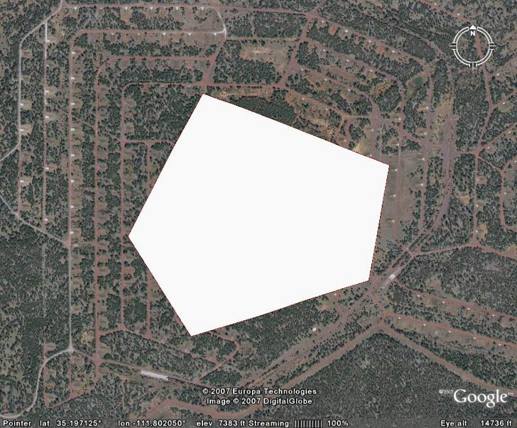
One big plus of GPS TrackMaker over EasyGPS is that it can upload polygon data created in Google Earth to a GPS as a track that traces the perimeter of the polygon. Here’s a screenshot of a polygon in Google Earth:

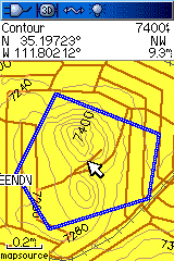
After saving the polygon in a KML file, opening it directly in GPS TrackMaker, then uploading it to my Garmin GPS, this is how the polygon perimeter appears as a track in the screen display:

There’s a lot more to this program: importing and calibrating background maps, drawing tools for creating tracks and waypoints, calculating track lengths, thinning tracks, and so on. In fact, if you’re only interested in using it from importing and exporting GPS data, it may have too many options; you might find EasyGPS’s simpler interface more convenient. But given GPS TrackMaker’s capabilities, and its freeware status, I’d call it a must-have GPS tool for Windows users.


after i make a route how do i superimpose it on then google map?
Save it as a KML file, and you can open it in Google Earth. For Google Maps, you’ll have to upload the KML file online somewhere, and then specify the web address of the KML file in Google MyMaps.
New version out!
File: gtm133.exe
Type: Program
Size: 13,58MB
Last Upgrade: 04/02/2008
Version #: 13.3.349
http://www.gpstm.com/downloads.php
:)
I agree Trackmakers a good program – does anyone have the Pro version? And how can I set a default view when I start up to just my area _ I get the whole earth and have to zoom endlessly in.
import and export of kml is easily made by azimutm GPS at http://azimutsoft.com