As a wrap-up to the “Google Earth Plus features for free” series, I’ll briefly comment on the three paid (albeit cheap) options for doing real-time GPS tracking with the free version of Google Earth.
Franson GPSGate Google Earth plug-in
I mentioned GPSGate in an earlier post – it converts a Garmin USB connection to an NMEA equivalent, and also splits a single NMEA connection into multiple serial connections, so that more than one program can receive data from your GPS at the same time. If you buy the Express edition of GPSGate (only two connections) for $9.95, or the Standard edition (unlimited connections) for $29.95, you can also download and install a free plug-in that lets you do real-time GPS tracking with Google Earth. Haven’t tried it, so can’t really comment on it, but from the screenshots and description it looks pretty good.
EarthTracker
EarthTracker will run for a few minutes, then timeout; you then have to re-start it. Registration for $10 stops the timeouts. The feature set looks pretty decent: supports NMEA and Garmin USB, fleet tracking then Supports Garmin USB connection, fleet tracking, comes with a data converter. But I was unable to get it to work correctly; with an NMEA connection, Google Earth opens and displays a position marker briefly before shutting down spontaneously; I suspect that one of the Google Earth API revisions broke it. And the Garmin USB connection didn’t work at all. But give it a shot – it might work for you. Comes with a PDF manual.
GETrax
GETrax has a 30-day free trial period, then requires $9.95 registration. Comes with a wide-variety of features, including APRS support, sending data to Google Maps, file conversion, etc., and worked fine on my system. Comes with a decent help file as well. Don’t know that I’d choose it over EarthBridge, but at least worth checking out in 30-day demo mode. DestinSharks has a review of this program, along with reviews of GooPs, EarthBridge, and Google Earth Plus.
In the first two parts of this series, I covered real-time GPS tracking in Google Earth using completely free solutions. These next two are free to download and use, but are donationware – if you wind up using them on a regular basis, the authors would appreciate a small donation to show your appreciation.
Continue reading ‘Real-Time GPS Tracking With Google Earth – DonationWare’
Rich of GPS TrackLog points out that the demo version of OziExplorer has the ability to open shapefiles, and export the data to a GPS. I’d avoided looking at OziExplorer because I thought it was shareware, and you’re obligated to pay $85 for registration to use it. But Rich is right – the demo version does let you import shapefiles, and send them to a GPS. And it does a bunch more as well:
Continue reading ‘GPS/GIS/Google Earth Import/Export With OziExplorer’
Here are three more completely free ways to do real-time GPS tracking with the free version of Google Earth.
Continue reading ‘Real-Time GPS Tracking For Google Earth – Free Options II’
Note: The free version of Google Earth now supports a basic version of live GPS tracking, but all this info is still relevant.
Here’s the first post in a series on real-time GPS tracking with the free version of Google Earth, starting with the completely free options, next donationware, then finally a couple of paid (but cheap) pieces of shareware.
Continue reading ‘Real-Time GPS Tracking For Google Earth – Free Options I’
Note: The free version of Google Earth now supports GPS, but all this info is still relevant.
Before I post about the options for doing real-time GPS tracking in Google Earth Free, there are potential complications to talk about: getting your GPS to communicate both with your computer, and with Google Earth. While Google Earth supports both NMEA and the Garmin USB PVT interface, most of the free and cheap options I’ll be talking about require an NMEA serial connection. Depending on what kind of GPS you have, and what kind of computer ports you have, that may be straightforward, but may not.
Continue reading ‘Real-Time GPS Tracking In Google Earth Free – Setup’
If you have a Google Analytics account tracking your website, here’s a fun little tool I just stumbled across. Analytics2KML will take geographic data generated in Google Analytics for your last 500 visitors, and convert it into a KML file for display in Google Earth. Just follow the simple directions on the website. Here’s shot of my recent European visitors:
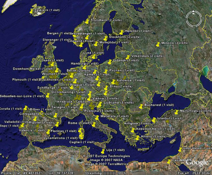
7/20/08: The raw data export function in Google Analytics no longer exists, so until it’s restored, this is the next best option.
Now that I’ve written a whole slew of posts about how to download and upload data to and from Google Earth with a GPS, using several pieces of software and multiple steps, I’ve just found one piece of freeware that simplifies the process tremendously. *sigh*
Continue reading ‘GPS TrackMaker: A Better Solution For GPS Export/Import With Google Earth’

