Addendum: This application has been removed, apparently because the author is working on something similar for commercial purposes. See this post at the Google Earth Blog for another application that does something similar.
From the GeoDatum blog comes a link to an application that displays satellite positions and visibility cones in Google Earth. 31 different categories of satellites are available, including weather and communications, but probably of greatest interest here is GPS.
Continue reading ‘GPS Satellite Display In Google Earth’
CorpsCon is the one coordinate converter to use if you’re only interested in NAD datum and coordinate conversions in the US. But since it only covers the US, only NAD, and only a limited number of coordinate systems (geographic, SPCS, UTM and NGRS), another free coordinate converter is needed for the rest of the world.
Continue reading ‘Coordinate Converters II – Worldwide Coordinate Conversion’
1:24,000 scale topographic maps from the United States Geological Survey (USGS) are a convenient cartographic resource, readily available from regional state GIS agency archives or the Internet Archive / Libre Map Project. However, many of the maps are seriously out of date, as much as twenty years or more.
Continue reading ‘Updated USGS 24K Topographic Maps From The US Forest Service’
I’ve posted before about how to convert shapefiles from one coordinate system/datum to another. But I sometimes have the need to convert individual coordinate points, or text files with sets of coordinate points, from one coordinate system and/or datum to another. This post is the first in a series on freeware coordinate converters.
Continue reading ‘Coordinate Converters I – NAD Conversions’
OgleEarth posts about Hey, What’s That?, a website that lets you enter a location and then gives you:
- A panorama of what’s visible from that location, marking the position of peak geographic landmarks
- A list of the peaks, and the ability to show their position relative to your location on Google Maps
- Terrain profiles (elevation versus distance from the location to any point on the map)
- A plot all the areas visible from that location in red on Google Maps (aka the “viewshed” or “weapons fan”)
- Contour lines (zoom in for these)
- Google Earth export of position, viewshed, horizon line and horizon extent. If the viewshed area is large, this might strain the memory capacity of lesser systems.
It uses 30-meter SRTM version 1 data for its calculations, so there may be some quirks depending on whether there are holes in the SRTM coverage for your area. They’re switching over to SRTM version 2 soon, which is better but still not perfect. It only works in the US right now, but according to OgleEarth, they hope to expand coverage worldwide. A cool site! Check the OgleEarth posting for more info.
Haven’t had a chance to try it yet, but RoadNav is an open source GPS Road Navigation program that uses TIGER data to generate street maps and turn-by-turn directions, gives verbal commands, and doesn’t require an Internet connection. Also runs on Linux and Mac OS X, in addition to Windows. I usually drive alone, and it’s a *really* bad idea to use a PC-based road navigation program as the driver, so I don’t know when I’ll get around to it. If anyone tries it out, please let me know how it works for you.
Addendum from the comments: Check out this SlashGEO posting for links to other freeware road navigation solutions.
The United Nations Food And Agriculture Organization (FAO) maintains the FAO GeoNetwork, a data portal for worldwide digital geographic information from the FAO, other UN agencies, NGOs and other organizations. Despite the “Food And Agriculture” in the name, there’s far more than just agricultural-related data here.
The FAO Portal Page has a web search interface for tracking down data. Not all the data is available in downloadable digital format – for much of it, only the metadata is available. If you’re only interested in digital data, just check “Digital” next to “Map type” box. Search results can be random in nature, and sometimes data listed as being available in downloadable format isn’t. But you never know what useful stuff might pop up. For example, here’s a map of the southern tip of Africa, plotted from 1:125,00 scale coastline vector data for Africa and Arabia derived from SRTM data:
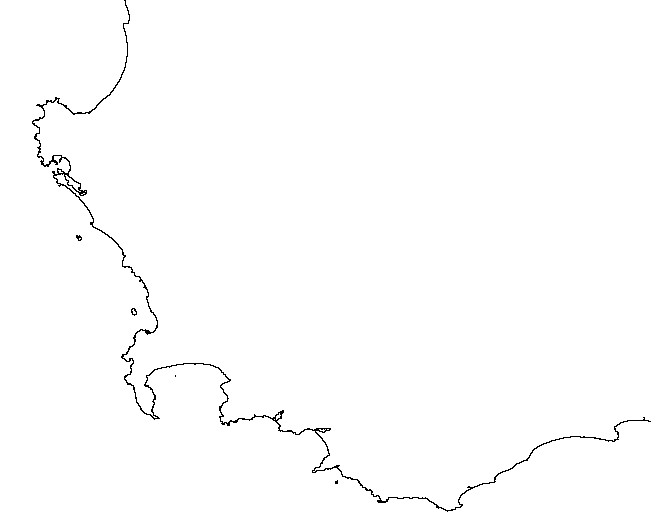
Recent coastline data with that kind of resolution isn’t always easy to find.
You can subscribe to an RSS feed that lists new datasets as they’re added to the portal. There’s also an interactive online mapping system for creating your own maps, and an extensive list of WMS servers with a wide variety of information you can add to WMS-compatible programs like MapWindow and Google Earth. You may not always find exactly what you need, but it’s definitely worth a look.
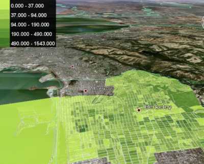
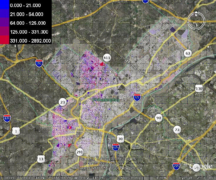
ExtremeTech has an article about the gCensus site, which lets you select US Census tabular data using a web-based interface, and convert it into a Google Earth KML file. Examples include a plot of population density in the Berkeley, CA area:
and a plot showing racial segregation in Philadelphia:
Only data from Summary File 1 is currently available, but the site creator intends to add additional data later on.

