blankblank blank


Author Archive for Leszek Pawlowicz Page 24 of 79


Free Resources For ArcGIS 9.3

The Mapperz blog posts about ESRI’s new Models and Scripts Gallery, a resource for sharing and downloading geoprocessing models and scripts for ArcGIS 9.3. There are similar galleries available for .Net, Javascript and Java code:

And the old resource page for Arcscripts is still available as well.


Small, Simple Tool For Getting Distances And Bearings Between Points In Google Maps

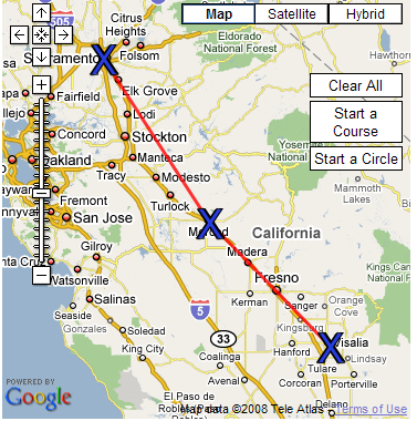
The Mapping and Distance Tools website lets you determine the compass bearing between sets of points. Zoom in to your desired area, click on “Start A Course”, and then click on the points you want (or enter a name or address to create a point). The tool will put X’s on the points, drawing lines between them:

Google Maps bearing and distance between points

As you create each point, the location of each point, the distance to preceding and succeeding points, and bearing will show up in a table:

Google Maps bearing and distance between points

You can also draw a circle on the map, though the utility of that option escapes me. And if you want to see how it’s done, the source code is available.


Make Your Own Topo Maps For A Garmin GPS Unit

Well, the good news is that Garmin is finally starting to offer 1:24K scale US topographic maps for some of their GPS units. While they’ve had these maps for US National Parks in the East, Central and West for quite a while, they’re now issuing them for the US as a whole. These are different from the 1:100K Garmin topo maps available for a while, with the latest release coming in 2008. But there’s bad news as well:

– The datasets come on individual microSD cards, so they’re only compatible with units that support those cards

– Because they’re on microSD cards, you can’t load additional map data like CityNavigator or BlueChart data on the cards; you need to either do without or swap cards back and forth to get the dataset you want

– Cards cover various sections of the US, aren’t cheap ($100 list, typically available for about $60-70 street), and only a limited part of the US is currently covered:

(Note: Garmin also sells 1:100K topo maps on microSD cards, and you have to read the product description carefully to find that out; in any case, you’re almost always better off buying these 1:100K maps on a DVD; you can then upload selected maps to the GPS unit)

There are options that are cheaper, and cover areas not currently available from Garmin. The MiscJunk website has 1:24K topo maps for UT, MT and WY, with CA on the way, though there’s already a map file for the entire state of CA already available. Dan Blomberg’s  GPSFileDepot site has 1:24K topo mapsets for Arizona and Mississippi, and he’s automated the process to a point where I suspect more state mapsets will be coming in the future.

But Dan has also put up a full tutorial section on how to create your own 1:24K topo Garmin mapsets, with full links to data and software sources. While I wouldn’t describe the process as simple and easy, it can be done by anyone with reasonable computer skills. And even if you don’t need a full topo map, similar procedures can be used to create simple Garmin point, line and area maps from GPS and GIS data that can be overlaid on top of other mapsets.

Other data resources for creating your own Garmin GPS maps:

The Yahoo Map Authors forum

Creating Custom Topo Maps For A Garmin GPS

GPS Maps

Make Your Own GPS Maps From GIS Data (TravelByGPS website)

Make Your Own GPS Map

KeenPeople.Com Tutorial One, Tutorial Two

New Zealand Open GPS Project tutorial

Custom Maps For Garmin GPS Receiver Part One , Part Two

… and I hope to cover some other free options for creating Garmin GPS maps in the near future.


Online 1:1M Geology Maps At The OneGeology Portal

The OneGeology website gives its mission as:

Make web-accessible the best available geological map data worldwide at a scale of about 1: 1 million, as a geological survey contribution to the International Year of Planet Earth.

While the official launch of the site is scheduled to coincide with the International Geological Conference in Oslo, August 6-14, the mapping portal site is already partially functional, although a few bugs and quirks still exist. It currently works with Internet Explorer 6/7, and Firefox 2, but not Firefox 3 (hope this changes soon). And while the goal is to have data for the whole world at a 1:1,000,000 scale, data for significant areas of the world are currently not available at that scale; for example, the US data is at the 1:5M scale. A partial list of the WMS data available and its scale is on this page.

Continue reading ‘Online 1:1M Geology Maps At The OneGeology Portal’


A Simple Online KML Polygon Creator – With Holes!

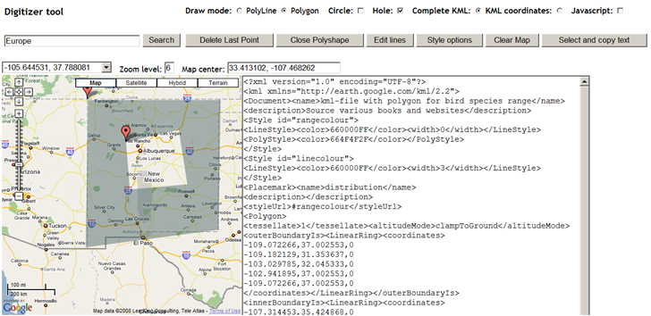
Kjell Scharning emailed to let me know of his simple Google Maps tool, a basic digitizer with a Google Maps interface for creating KML polyline and polygon files. While for most purposes, the Google Maps MyMaps creation tool is a better choice, Kjell’s tool does have some useful functions missing from the Google Maps editor:

  • Creating circular shapes
  • Creating polygons with holes in them (something you can’t do directly in Google Earth, either)
  • Get a list of vertex coordinates as created (select the “KML Coordinates option”). There’s also a separate KML “editor” that will take a link to a KML file, and give you a text list of the vertex coordinates. You can move the vertices around in the “editor”, but it doesn’t actually edit the KML, just modify the coordinates in the list.

As you click on the Google Maps interface to create vertices for the polyline or polygon, the KML text will be updated in real-time in a text window to the right of the map:

Google Earth shape with hole

The instructions are a little unclear on hole creation. To create a shape with a hole:

  • Choose the “Polygon” Draw mode
  • Set the style for the shape (color, fill, perimeter) with the “Style options” button, then draw the shape in the map. Be sure to end the shape by clicking the “Close Polyshape” button.
  • Check the “Hole” box; the perimeter of the main shape will turn into a polyline, and the draw mode will switch to “Polyline”.
  • Draw the shape of the hole on the map, using the “Close Polyshape” button to finish the hole.
  • Click the “Polygon” Draw mode option, and you’ll see your original shape with the hole inside of it.

Once you’re done, click the “Select and copy text” button, then paste the code into a text editor and save it as KML file.

It currently only seems to work in Internet Explorer and Firefox 2, but not in Firefox 3. And you can only draw one shape at a time. Not a complete editor by any means, but you may find its unique features handy.


Uploading .img Map Files To A Garmin GPS Unit With MapUpload

A while back, I posted about MapSet Toolkit, a program that adds information about Garmin-map-format .img files to MapSource, so you can upload them with that program to a compatible Garmin GPS unit. But there are several faster and more direct ways to upload a .img file to a Garmin unit which don’t require installation in MapSource; they may be more convenient for a single map file, or for evaluating a map file before installing it as a MapSource option.

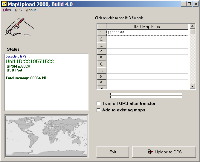
The first one I’ll cover is MapUpload, from the creators of MapWel, a program for creating custom maps for Garmin GPS units. MapWel isn’t free, but MapUpload is; there’s a list of supported Garmin units on this page.  Just download and run (no program installation):

3-16-2008-7.06.02 PM

If your GPS unit is turned on, it should be recognized automatically, and info displayed in the Status window. If it’s off, turn it on and select “Detect GPS” from the GPS menu. Select .img files by clicking on the list at left (or the menu Files => Add img files to the list), and using the file selection dialog; there’s room for up to 300 files on the list. Click on “Upload to GPS”, and the maps will be sent to your GPS. There’s no way to tag a set of maps with a label; on your GPS, they’ll all have the category label “Custom area created with Mapwel”, followed by the .img creation date.

The default is to delete the current mapset, but if you check the box “Add to existing maps”, the maps on the list will supposedly be added to the maps currently loaded onto the GPS. I’ve had mixed success with this option – it seems to work better with small installed mapsets than with large ones. And if you have a large set of maps on your GPS, it will take a while to merge them, since the connection is either serial (unbearably slow) or USB 1.1. (painfully slow), and MapUpload first has to download the full mapset, then merge it with the new maps, then upload it back again. It doesn’t support the faster option of uploading data onto a memory card in a higher-speed (USB 2.0) card reader. There’s also no way to save a map list, so you have to select individual map files every time you want to do an upload. On the plus side, you can create a stand-alone program that takes all the .img files, and puts them into an executable that will upload the data to any attached, compatible Garmin GPS unit.

On the plus side, MAPUpload is fast and simple. If I have one or two maps I need to upload quickly, especially if I want to merge them with the current mapset, it’s my program of choice. For larger sets of maps, you’re better off using MapSet Toolkit, or other options I’ll cover soon.


Create Bicycle/Travel Courses For Your Garmin Edge/Forerunner GPS With Bike Route Toaster

Although it’s primarily aimed at bicycling Garmin Edge/Forerunner owners, Bike Route Toaster is a useful tool for any GPS user, or anyone planning a bike road trip. Create a course in a Google Maps interface by adding points along the route; Bike Route Toaster gives you the option of auto-routing, where it connects the points along roads and adds directions:

Continue reading ‘Create Bicycle/Travel Courses For Your Garmin Edge/Forerunner GPS With Bike Route Toaster’


Plot Google Analytics Geographic Data In Google Earth/Maps

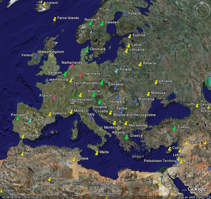
Johann Blake writes about his new tool to plot geographic Google Analytics data in Google Earth or Google Maps. Just follow the instructions on the website to export the Analytics data in XML format to your computer, then upload the file to the site. You have the choice of creating either a straight KML file for Google Earth, or a direct plot of the data in Google Maps; the latter doesn’t seem to work currently in Firefox 3, but does work in Internet Explorer. You get placemarks for every country from which you had a visitor, color/type coded by the total number of visitors:

gega

Click on a placemark in either Google Earth or Google Maps to see the number of visitors from that country. You can use the standard Google Analytics controls to select the desired time frame, and also filter data.

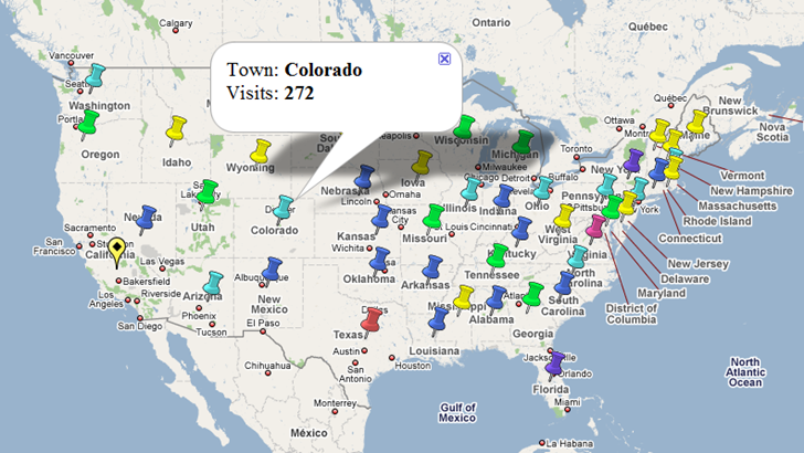
It appears as though you can also select geographic sub-regions in Google Analytics like the US states below. I did get a bunch of error messages in Google Maps, and the District Of Columbia plotted in the South Atlantic, before the rest of the states plotted correctly:

7-20-2008-8.55.39 PM

This older tool was able to plot individual visitors, but required a raw data export capability that Google Analytics no longer provides. So for now, Johann’s site is the best available GE/GM Analytics tool.