For converting to and from the Military Grid Reference System (MGRS) and UTM/LatLong, the MGRS Conversion Utility from Mentor Software is a small utility (365kB download) which does only that. During installation, everything stops for a long while, but it’s not a crash – it will eventually complete the installation process. Once installed and run, just enter one of three kinds of coordinates, UTM, latitude/longitude, or MGRS, click Enter next to the entered coordinates, and they will be converted to the other two coordinate systems:
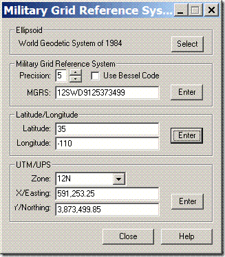
You can choose from 61 different datums in the “Ellipsoid” section at top. Latitude/longitude can be entered in decimal degrees, or as degree-minute-second with each set of numbers separated by a space. Set the MGRS precision with the up/down arrows; check “Use Bessel Code” for those areas where it’s appropriate for MGRS (mainly Europe – see the help file for more info).
And if you’re interested in displaying MGRS coordinate data in Google Earth, the Nearby.org.uk website has a link that plots MGRS gridlines in Google Earth, with a central marker that displays the 1-meter MGRS reference.
Addendum: See this post for a roundup of MGRS utilities.