blankblank blank


Worldwide Contour Lines In Google Maps’ Terrain View


Google has just announced the addition of topographic contour lines to their Terrain view in Google Maps. It’s for the entire world, so I suspect they’re using SRTM 90-meter resolution data; not ideal, but not bad, either. Here’s Popocatepetl, just SE of Ciudad de Mexico:

snapper1207179499156

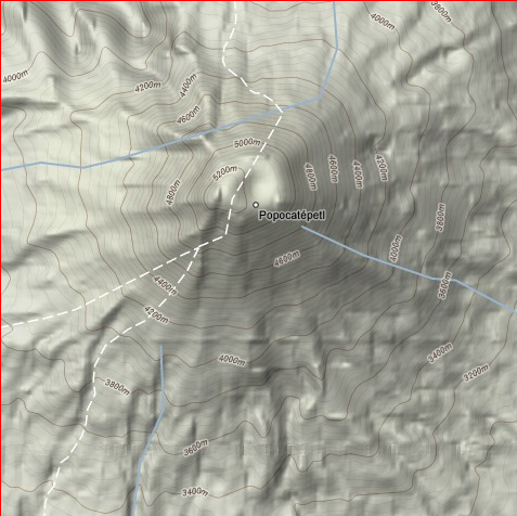
You have to zoom in to at least the 1-mile / 2 km range for the contours to appear.

Other posts in the Google Maps Tools series

  1. Coordinate Data From Google Maps
  2. Reverse Address Geocoding With Google Maps
  3. Converting Google Maps Search Results To GPX
  4. Coordinate, Elevation, Distance And More In Google Maps
  5. Google Maps "My Maps" Features
  6. Measuring Elevation, Distance And Area In Google Maps
  7. Creating GPS Routes In Google Maps
  8. Thematic Polygon Shapefile Display In Google Maps
  9. Using The Google Maps Interface To Display General Maps And Images
  10. Heat Mapping In Google Maps
  11. Elevation Profile In Google Maps
  12. Embed Google Maps "My Maps" On Your Web Page
  13. Customizing Google Maps Markers
  14. Two Fun Cartographic Google Maps Tools
  15. Simple Guide To Embedding Google Maps "My Maps" On Your Own Webpage
  16. Another Google Maps Geocoder/Reverse Geocoder
  17. Drawing Lines Between Points In Google Maps, Straight And Great Circle
  18. Convert A Google Maps Point To Multiple Text Geographic Formats
  19. Meet Your Friends Halfway
  20. Plotting Swivel Data In Google Maps
  21. Meet Your Friends Halfway II
  22. Geographic Midpoint Calculator
  23. GIS-Like Functionality In Google Maps With ZeeMaps
  24. Creating GPS Waypoints Online From The USGS Geographic Names Information System (GNIS)
  25. MapMyRide.com
  26. Exporting KML Data From Google Maps MyMaps To A GPS
  27. Advanced Tool For Embedding Google Maps MyMaps On Your Website
  28. Draw/Label On Google Maps, And Generate GPX/KML/Embeddable Maps
  29. Another Way To Create Embeddable Google Maps With KML Data
  30. Documenting A Journey With Maptales
  31. Plot A Coordinate Position On Different Map Pages
  32. Worldwide Reverse Geocoding With Google Maps
  33. Google Maps Shaded Relief Site Updates
  34. Digipoint 2: Export Of Google Maps Points In Multiple Formats, And Elevation Data
  35. Google Maps Line Tool Now Supports Distance Measurement
  36. Geographically-Linked Video With VeoGeo
  37. Recent Google Maps Tools
  38. Google Maps Mapplets From Zonums Software
  39. Maximize Google Maps With Google Maps Max
  40. Mapping Zip And Area Code Boundaries, And More
  41. Altitudes And Terrain Profiles In Google Maps
  42. “Friendly” URLs To Address Maps
  43. Quick Zip Code Information
  44. Simple Online Form For Creating An Embeddable Google Map
  45. Embed Synchronized Google/Microsoft Virtual Earth Maps On Your Website/Blog
  46. Worldwide Contour Lines In Google Maps’ Terrain View
  47. Plot Gazetteer Features In A Google Maps Interface
  48. Antipodes Map

Looking for something else? Enter some keywords below, then click "Search".
"This site" searches Free Geography Tools; "Web" searches the Internet using Google.


5 Responses to “Worldwide Contour Lines In Google Maps’ Terrain View”


  1. 1 widadi

    thank’s for all. software free.

  2. 2 Tarek

    thanks for the info but i need to know if you are sure that this is really SRTM 90-meter resolution data;
    if so do u know any other tool can give me more accurate data

  3. 3 Leszek Pawlowicz

    I don’t know this for sure, but the SRTM-90 dataset is the only one that covers the entire world. You can always download the SRTM-90 data for yourself, and convert it to contours (search this blog for posts that describe how to do this).

  4. 4 LobanDante

    Do you know if it is possible to export the contour line layer to a CAD application?
    I need to a school work… Nothing big, but enough to work on.
    From what I just saw, I guess the contour lines are drawn every 20 meters. It’s not perfect but I guess I can work on that.
    Can anyone help me?

  5. 5 Leszek Pawlowicz

    No, you can’t export the countours. You’d have to get the DEM data used to create the contours, and then generate DXF files from that data. It can be done – search this site for posts on creating shapefile contours from DEM data, and then converting the shapefiles into DXF.

Leave a Reply


I welcome all legitimate comments. But spammers should know that my spam filters are currently blocking almost 100% of comment spam, and any that gets through the filters is immediately deleted. Don't believe me? Try posting a spam comment, and see what happens.

Powered by WP Hashcash