Global Mapper is a first-rate program for viewing and converting GIS data, raster (image and elevation) and vector. It opens over 100 different raster/vector formats, with on-the-fly support/display conversion of virtually every coordinate system / projection / datum you can think of, and some you might not (the Moon, Mars, the moons of Jupiter). It comes in a demo version with the following limitations (from the help file):
- You will be unable to export data to any format.
- You will be limited to loading a maximum of 4 data files at a time. With the full version, you can load any number of data files simultaneously.
- No 3D capabilities (full version supports 3D views, viewsheds, line of sight, cut-and-fill volumen
- You will be unable to load workspaces.
- You will be unable to work with map catalogs.
- You will be unable to download data from WMS map servers.
- You will be unable to save rectified imagery to fully rectified files.
- You will not be able to print to a specific scale (i.e. 1:1000).
- You will have to endure a nagging registration dialog every time that you run the program.
- You will not be eligible for free email support.
There’s one more, which is you don’t have the option of printing/exporting the screen display as an image file (though you can still print to a printer what’s visible on screen; zoom in to get a higher-resolution printout). Global Mapper’s display options for vector objects are also more limited than a standard GIS data viewer (e.g. no coloring by attribute for shapefiles). For those two reason, the TatukGIS viewer may be a better choice, since it lets you export the data view, raster or vector, as a high-resolution georeferenced raster image. But TatukGIS Viewer only supports about 30-odd raster and vector file formats, and doesn’t do on-the-fly re-projection. For examining the occasional odd data format you run across, in unusual projections/coordinate systems, and making a quick print, Global Mapper is good to have in your toolbox.
As a bonus, it also has a great line/area measurement function, which lets you modify the measurement units from metric to English and back on the fly, and copy them into the clipboard:
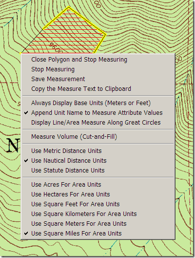
The TatukGIS Viewer has a measure function, but it gives area only in the data’s native projection, less than useful if it’s in the geographic coordinate system (e.g. square degrees for area).
Finally, if you’re looking for an all-purpose data format converter with batch conversion capabilities, don’t need the considerable power (or expense) of FME, and don’t want to deal with the GDAL command-line utilities, you could do far worse than the $299 fully-registered version of Global Mapper.
I have used Global Mapper in 2 years and I am way satisfied.
The online support in the forum is a great help epically when you are not born into the GIS world.