An earlier post covered MapUpload, a free program for uploading .img files to a Garmin GPS; another option for this operation is IMG2GPS. This is actually a limited front-end to the command-line program SendMap (included in the IMG2GPS install package), but it supports most of SendMap’s upload features you would normally use.
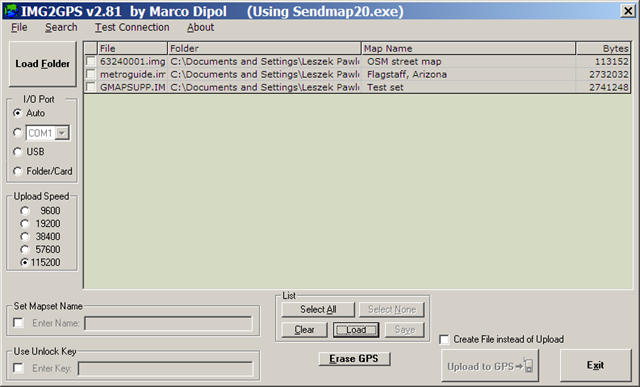
You don’t select .img files for loading into the selection list individually; instead, you specify a folder using the “Load Folder” button, and all .img files in that folder are automatically added to the list. Selecting another folder will add those .img files, while not erasing the ones already there. To erase all the files in the list, click the “Clear” button at the bottom; this clears all the files in the list, regardless of whether they’re selected using the check box. You can save a list of selected files with the “Save” button, and load that list with the “Load” button; it also supports the .gdb format created by MapSource. Finally, you can search through the list of files for a text string in either the filename or the map name using the “Search” function at the top.
To upload one or map files to your GPS, select them with the check box, make sure your GPS unit is turned on, and click “Upload to GPS”. In “Auto” mode, the program should automatically detect a connected GPS, running through all the options (USB and all COM ports). If the program has difficulty recognizing that you have a GPS connected, you can use the “Test Connection” function at the top to help diagnose the problem; you can also manually specify the I/O port your GPS is hooked up to. You can also set a mapset name label for all the maps being uploaded by checking the box below, and entering the desired label.
Unlike MapUpload, IMG2GPS supports uploading to a data card (like a microSD card) in a card reader, which can be faster if the card reader is USB 2.0 (most Garmin GPS units are USB 1.1). Oddly, it doesn’t seem that you can do it directly using the “Folder/Card” option for I/O Port. Instead, you have to combine all of the selected maps into a single “gmapsupp.img” file, and then upload that file to the “Garmin” folder on the data card (see this post for more info on the “gmapsupp.img” file). To do this, check the box at the bottom marked “Create File instead of Upload”; this will change the button below to “Create File”. Press the button, and then select the “Garmin” folder on the data card to save the “gmapsupp.img” file in (create the folder if it’s not already there). When you put the card back into the GPS, the “gmapsupp.img” file will be recognized and read as a map file.
There’s another front-end for Sendmap called GPS Send Map, but it’s obsolete, doesn’t appear to be in development anymore, and doesn’t have the features that IMG2GPS has.


Awesome tool spent 3 days trying to figure out how to convert img file to work with mapsource and I did it in less then 5 mins with this tool
Thanks form Ontario
Dusty