blankblank blank


Small, Simple Tool For Getting Distances And Bearings Between Points In Google Maps


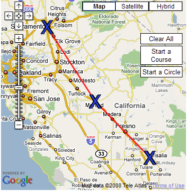
The Mapping and Distance Tools website lets you determine the compass bearing between sets of points. Zoom in to your desired area, click on “Start A Course”, and then click on the points you want (or enter a name or address to create a point). The tool will put X’s on the points, drawing lines between them:

Google Maps bearing and distance between points

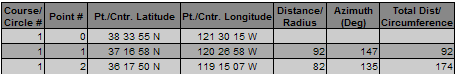
As you create each point, the location of each point, the distance to preceding and succeeding points, and bearing will show up in a table:

Google Maps bearing and distance between points

You can also draw a circle on the map, though the utility of that option escapes me. And if you want to see how it’s done, the source code is available.

Other posts in the Google Maps Tools series

  1. Coordinate Data From Google Maps
  2. Reverse Address Geocoding With Google Maps
  3. Converting Google Maps Search Results To GPX
  4. Coordinate, Elevation, Distance And More In Google Maps
  5. Google Maps "My Maps" Features
  6. Measuring Elevation, Distance And Area In Google Maps
  7. Creating GPS Routes In Google Maps
  8. Thematic Polygon Shapefile Display In Google Maps
  9. Using The Google Maps Interface To Display General Maps And Images
  10. Heat Mapping In Google Maps
  11. Elevation Profile In Google Maps
  12. Embed Google Maps "My Maps" On Your Web Page
  13. Real-Time Website Visitor Plotting In Google Maps
  14. Customizing Google Maps Markers
  15. Two Fun Cartographic Google Maps Tools
  16. Simple Guide To Embedding Google Maps "My Maps" On Your Own Webpage
  17. Another Google Maps Geocoder/Reverse Geocoder
  18. Drawing Lines Between Points In Google Maps, Straight And Great Circle
  19. Convert A Google Maps Point To Multiple Text Geographic Formats
  20. Meet Your Friends Halfway
  21. Plotting Swivel Data In Google Maps
  22. Meet Your Friends Halfway II
  23. Geographic Midpoint Calculator
  24. GIS-Like Functionality In Google Maps With ZeeMaps
  25. Creating GPS Waypoints Online From The USGS Geographic Names Information System (GNIS)
  26. MapMyRide.com
  27. Exporting KML Data From Google Maps MyMaps To A GPS
  28. Advanced Tool For Embedding Google Maps MyMaps On Your Website
  29. Draw/Label On Google Maps, And Generate GPX/KML/Embeddable Maps
  30. Another Way To Create Embeddable Google Maps With KML Data
  31. Documenting A Journey With Maptales
  32. Plot A Coordinate Position On Different Map Pages
  33. Worldwide Reverse Geocoding With Google Maps
  34. Google Maps Shaded Relief Site Updates
  35. Digipoint 2: Export Of Google Maps Points In Multiple Formats, And Elevation Data
  36. Google Maps Line Tool Now Supports Distance Measurement
  37. Geographically-Linked Video With VeoGeo
  38. Recent Google Maps Tools
  39. Google Maps Mapplets From Zonums Software
  40. Maximize Google Maps With Google Maps Max
  41. Mapping Zip And Area Code Boundaries, And More
  42. Altitudes And Terrain Profiles In Google Maps
  43. “Friendly” URLs To Address Maps
  44. Quick Zip Code Information
  45. Simple Online Form For Creating An Embeddable Google Map
  46. Embed Synchronized Google/Microsoft Virtual Earth Maps On Your Website/Blog
  47. Worldwide Contour Lines In Google Maps’ Terrain View
  48. Plot Gazetteer Features In A Google Maps Interface
  49. Antipodes Map
  50. New Features At MapChannels.Com
  51. Small, Simple Tool For Getting Distances And Bearings Between Points In Google Maps


Subscribe to this blog's RSS feed

1 Response to “Small, Simple Tool For Getting Distances And Bearings Between Points In Google Maps”


  1. 1 Bassam

    thank u very much for this simple tool

Leave a Reply


Be sure to enter the "reCAPTCHA" below before submitting your comment.