PhotoKML is a small (<300K download) Java application (PC and Mac) that takes a folder full of geotagged photos, and creates a KML file with points linked to moderate-sized thumbnails of those photos. Interface is simple; select a folder containing georeferenced photos, and a folder where you want to save the KMZ file:
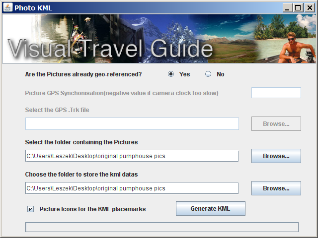
Make sure the “Yes” button is selected at the top. While the program says it’s able to georeference photos using a GPS file, the only format it accepts is the “.trk” format. If you have your track in a more standard format like GPX, good luck finding a program that can convert it to the “trk” format (I couldn’t even get GPSBabel to work). If you want the point icons in Google Earth to be mini-versions of the pictures instead of pushpins, check the box at the bottom.
Click “Generate KML”, and you’ll have your KMZ file in a few seconds; you’ll have to open it manually in Google Earth:
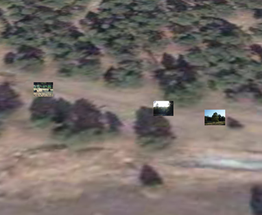
Nothing fancy, but PhotoKML does the job quickly and easily.
It doesn’t seem to work for me on Mac OS 10.5.3. :(
When I try to load photos I know are 100% geotagged, it doesn’t let me open them.
It’s a shame, as I don’t always want to export to KML/KMZ from iPhoto all the time.
Anybody else had this problem?
Sorbus
Don’t have a Mac, so I’m not able to answer your question about why PhotoKML doesn’t work for you. Have you tried Prune:
https://freegeographytools.com/2008/prune-updated-now-with-automated-photo-geotagging-for-windows-mac-and-linux
or GPicSync:
https://freegeographytools.com/2007/photo-geotagging-iv-gpicsync
Supposedly, both are Mac OS X compatible.
I got a bit confused with the interface, because it doesn’t like my geotagged images… It does indeed load the files, but the export function appears broken. I tagged them with GPS-PhotoLinker as it has the easiest and Mac friendliest interface: http://oregonstate.edu/~earlyj/gpsphotolinker/
Somehow PhotoKML doesn’t detect the geotag in the EXIF stamps, even though iPhoto, Preview and several Windows geotagging programs read them okay. It will still create a KMZ file, but when decompressed as a ZIP, there’s no KML file inside – Google Earth therefore won’t show anything. Having Googled this, it seems as though this is a common problem.
Thanks for the other links, I’ll see if they work well with my other programs!
Why do you call it PhotoKML and have a button that says Generate KML when in fact it only produces KMZ – I want a KML file – that’s why I downloaded it.
PhotoKML isn’t my program. It needs to generate a KMZ file, because that’s the only format that actually holds both the photos and the KML location information together in a single file. KMZ is fully compatible with Google Earth.
If you absolutely need to have just the KML data alone, without the photos, you have two options:
1. Change the KMZ extension to ZIP, then open the file in any zip program (like WinZip or 7Zip). You’ll see the KML file and the photo files togehter.
2. Open the KMZ file in Google Earth, then right-click on it, choose Save Place As, then select KML as the type you want to save it as.
Thank you for the help, it is definitely appreciated.
Bob