The Nearby.org.uk site has a pair of replacement compass indicators for Google Earth:
The Compass Star replaces the standard Google Earth compass indicator:

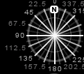
with one that has an angular degree scale, and finer divisions:
The Magnetic Compass is supposed to do something similar, but this time displaying the direction of magnetic north at any location:

… but sometimes it doesn’t seem to work right.
NOAA has a website that will give you the magnetic declination (the deviation between true and magnetic north) for the present, or any date after 1900, for the entire world. For the US, there’s also a page that gives you that value for dates before 1900. Links to graphic maps of declination and other info are available here.