Note: Site may be dead.
In a previous post, I described two basic online map projection viewers. Today, I’ll talk about another online map projection viewer that has far more capabilities than the first two, and is also a lot more fun to play with.
The plainly-named Map Projections site comes from the Instituto de Matematica of the Universidade Federal Fluminense in Brazil. Embedded in the site is the Java app that lets you display and manipulate map projections:
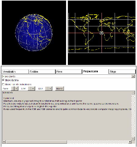
Each of the five tabs brings up a different set of options:
– Projections tab (default)
Choose from 72 different projections using the drop-down menu. As you select a projection, it will be displayed at the upper-right. Use the +/- buttons to zoom in and out, and move the map display left/right/up/down. The “Show Outline” button just highlights the outer edge of the projection, while “Show Tissot’s Indicatrices” plots circles of constant radius on the globe, and shows the corresponding circle on the map projection with its inherent distortions.
Cool feature here: click and drag on the projection display, and you will change the position you’re viewing the projection from. For example, by clicking and dragging on the projection above, you get this:

You can also change the globe view by clicking and dragging on it. To mark a position on the globe (the white spoked ring), and have it marked on the projection as well, depress the “i” key and then click on the globe; the lines of constant latitude and longitude for that point will be drawn in red on both displays.
– Visualization tab
Lets you turn on and off features like boundaries, circles, tropics, etc.
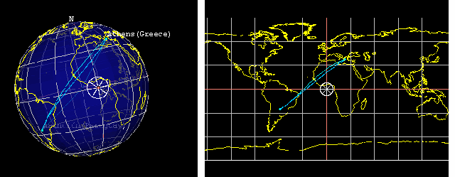
– Position tab
The top shows the latitude/longitude of the white spoked ring plotted on the map. There are also two drop-downs that let you choose two world cities, gives you the distance between them, and plots the great circle route. Check the “Show loxodrome curve”, and it will plot the loxodrome (line of constant compass bearing, aka rhumb line) between the two points:
– Place tab
Select a country from the drop-down, and the white spoked ring will be plotted there, the globe will be centered on that country, the countries flag and capital will be displayed below, and clicking on the “Consult Wikipedia” button will open the Wikipedia page for that country.
– Rings tab
Turns the white spoked ring on the map display on and off, and lets you set the ring’s diameter and number of spokes.
About the only significant limitations of the program are that you can’t re-size the image to make it larger, you can’t save the image without using a screen capture program, and you can’t select an alternate image for the projection display. Besides that, not only is it the best interactive online map projection viewer I’ve found, it’s better as a learning tool than the stand-alone programs I’ll cover in future posts (although the stand-alones have useful features of their own).