The TatukGIS Viewer and MicroDEM are handy all-purpose utilities to use for embedding and extracting worldfile data from a variety of image formats. But if you’re only working with TIFF image files and their worldfiles (*.tfw, *.tifw), GeoTiffExaminer may be a better choice:
– Small program (less than 500K installed)
– Modifies only the header, and doesn’t touch the image data. Both TatukGIS Viewer and MicroDEM rewrite the images when they save them, and sometimes you can get minor shifts in the color palettes that way
– Supports indexed color (the standard format for USGS DRG topo maps); MicroDEM doesn’t, and TatukGIS Viewer doesn’t always save the color palette on indexed colors correctly.
– Simple interface
There are two modes of operation: opening a GeoTiff, extracting the geodata and using it to create a worldfile; and opening a plain TIF file with a worldfile, and embedding the geodata from the worldfile in the TIF to create a GeoTiff.
Extracting a worldfile:
1. Use the Browse button to select the GeoTiff file you’re working with. The program will detect whether the TIF is a GeoTiff, and extract out the data it needs to create the worldfile:
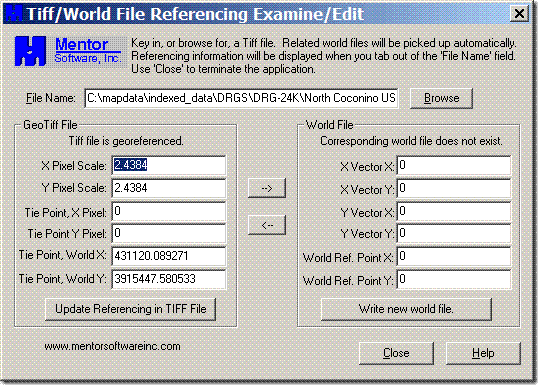
2. Click the “–>” arrow, and the geodata from the GeoTiff will be copied over from left to right:
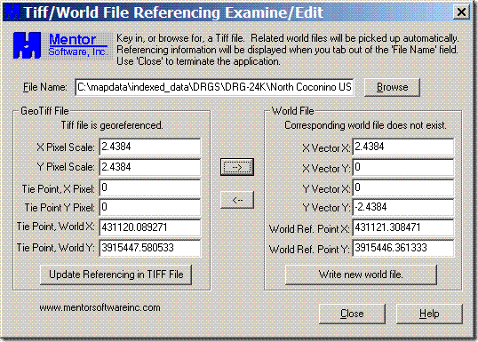
3. Click the “Write new world file” button, and a *.tfw worldfile will be written with the same file prefix name as the image file, e.g. if the GeoTiff is named “DRG.tif”, the new worldfile written will be “DRG.tfw”.
Embedding worldfile data into a TIF file to turn it into a GeoTiff:
1. Open the TIF file using the Browse button.
2. You must have the worldfile in the same directory as the TIF file, and it must have the same filename as the TIF file but with the “.tfw” extension. GeoTiffExaminer will recognize it, open it at the same time as the TIF file, and show the data in the “World file” section on the right. If it can’t find the world file, it will say, “Corresponding world file does not exist”.
3. Click the “<–” arrow to copy the data from the worldfile section on the right to the Tiff file section on the left.
4. Click the “Update Referencing in TIFF File” button, and the georeferencing data will be written directly into the header of the TIF file you opened in step 1. The original TIF is now a GeoTiff with georeferencing data embedded.
If you have a non-TIFF image file with a worldfile, but want to turn it into a GeoTiff:
1. Open it in the image editor of your choice.
2. Without resizing or otherwise changing it, save it as a TIFF.
3. Change the name of the worldfile to have the same filename as the image, but with .tfw as the file extension.
4. Use GeoTiffExaminer as above to embed the worldfile data into the TIFF file.
GeoTiff Examiner doesn’t extract or embed coordinate system (e.g. UTM, lat/long) or datum (e.g. WGS84) data, so you’ll have to keep track of that for your image file.
I am creating large geotiffs in Microdem and then using a paint program to modify the images colours and tones – I am not changing the images dimensions. The paint program, Paint Shop Pro 9, does not read or write the georeferencing so I am using Geotiffexaminer but I find that sis map modeller 6 does not recognise geoftifs that have had the headers modified by or created by Geotiffexaminer. Any suggestions of how to rectify this, alternate header modification software etc would be most welcome.
Check out my post on LibGeoTiff GUI; it will extract and embed the full file metadata, not just a worldfile.
https://freegeographytools.com/2007/a-new-gui-for-the-libgeotiff-worldfile-utilities