blankblank blank


Archive for the 'GPS' Category Page 20 of 25


Geotagging Photos With iTag

Ogle Earth has done posts on using Picasa to geotag (aka geocode) photos in both the stand-alone version of Picasa, and online in PicasaWeb albums. There are a fair number of other stand-alone programs for geotagging photos in a wide variety of ways, many of which include other useful features (like inserting the photos into Google Earth or Google Maps). Over the next few weeks, I plan to review a fair number of these programs on this blog.

First up is iTag, an IPTC tag installer. Its principal function is to add title, description and keyword tags to photos, but it does have some geotagging capabilities. iTag opens entire folders with pictures, and displays their contents in thumbnail format:
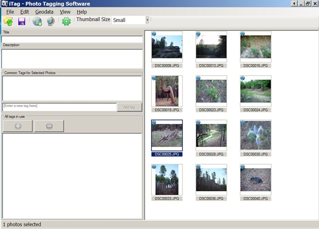
itag.jpg

If your photos are already geocoded, iTag can create placemarks with a photo thumbnail bubble in Google Earth, though this can take a while depending on how large the photo size is:
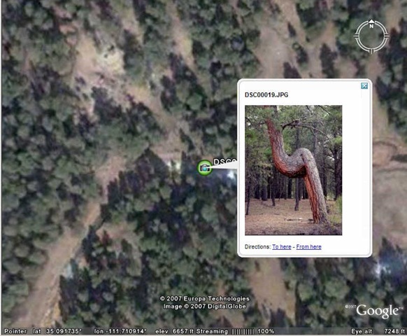
itagge1.jpg

You can save the placemark from Google Earth, but iTag also lets you create a KMZ file with the photo (or photos) embedded directly in the file, or linked to an internal or external location.

Geotagging a photo or group of photos is a multi-step process. You need to first create a placemark at the desired location in Google Earth. iTag’s default geotagging process is to take KML placemark data copied into the Window’s clipboard (right-click on the placemark and choose Copy), and use the geographic data embedded in that to geotag the photos. You also have the option of using a saved KML placemark file to geotag the photos. I prefer Picasa’s method of geocoding the position directly in Google Earth by selecting the photo in Picasa and then choosing the position with a cursor in Google Earth, but there may be occasions when iTag’s placemark process might be more convenient.

iTag lets you copy EXIF GPS data to the IPTC tags and vice versa, and also erase the geographic data completely from the photo. It also can convert GPX waypoint files to KML, so that you can use individual GPS points to geotag your pictures (but there are better ways to do this that will be covered in future posts).

iTag is a convenient way to apply descriptive tags and keywords to a photo or group of photos, better than the Picasa IMO because that’s all it does. The geotagging capabilities are a convenient bonus, but here I think Picasa is easier to use in most (if not all) cases.


Creating GPS Waypoints Online From The USGS Geographic Names Information System (GNIS)

The USGS GNIS is a gazetteer database of close to two million geographic landmarks in the United States (and, oddly enough, Antarctica as well). Types of landmarks include manmade (airports, hospitals, populated places, etc.) as well as natural (summits, arches, cliffs, etc.). There’s a direct interface to the GNIS at the USGS’s Board Of Geographic Names website that lets you search by feature name and get:

  • Federally recognized feature name,
  • Feature type,
  • Elevation (where available),
  • Estimated 1994 population of incorporated cities and towns,
  • State(s) and county(s) in which the feature is located,
  • Latitude and longitude of the feature location,
  • List of USGS 7.5-minute x 7.5-minute topographic maps on which the feature is shown, and
  • Names other than the federally recognized name by which the feature may be or have been known.
  • Links to sites offering map viewers for graphical display of the feature
  • Link to site offering information about the watershed area in which the feature is located

You can also download tab-delimited text files for individual states, or all states in one large file.

There’s another site with GNIS data, plus some extras. Wayhoo.com lets you search a copy of the GNIS database for US features, but has some additional options as well:

  • Browse for features by county, filtering by feature type
  • Add features to a waypoint list, then export the list directly from the browser to any GPS waypoint format supported by GPSBabel (GPX, EasyGPS, Garmin MapSource, Fugawi, OziExplorer, etc.)
  • Plot the feature’s location in Google Maps, Yahoo Maps, Virtual Earth, Terraserver, and a bunch more
  • Find the National Weather Service 7-day forecast for that location
  • Find the nearest recorded Degree Confluence point
  • Find the nearest geocaches
  • And a bunch more …

And Wayhoo requires no registration; you just need to have cookies enabled on your browser if you want to create a waypoint list.


MapMyRide.com

Lifehacker posts about MapMyRide.com, a new workout-oriented Google Maps site:

  • Display a USGS topo map in addition to the standard Google Maps views
  • Measure distances
  • Import a GPS track
  • Create a route, export it to GPS or Google Earth format, annotate it with markers for parking, bathrooms, etc.
  • Calculate the number of calories you’ll burn
  • Save and track your data (requires registration)

Free, but lots of ads (the price you pay …). Some of the features (e.g. Map Settings, Workout Calculator) don’t seem to work in the Firefox browser, but work in Internet Explorer (Windows).


Cheap Worldwide Road And Contour Maps For Garmin GPS Units

Most handheld Garmin GPS units come with a baseline road map that displays major roads for either the Eastern or Western hemisphere, plus the ability to display greater detail using uploaded map data. Garmin sells a line of CD/DVD disks with data for various parts of the world, and third-party sources offer maps with greater details for specific countries (a Google search should reveal even more). Many of these datasets are expensive, and data is unavailable for some areas of the world. There’s a cheaper option that offers worldwide data, including coverage of areas not covered by commercial products, but with some limitations in quality and detail.

Continue reading ‘Cheap Worldwide Road And Contour Maps For Garmin GPS Units’


Update On GooPs – Real-Time GPS Tracking In Google Earth

A while back, I posted on GooPs, one of a number of options to feed GPS data directly to the free version of Google Earth, lessening the need to spend $20 on Google Earth Plus, while getting fewer features. Today, a Google Earth Blog post indicates that GooPs has gone through some recent updates and changes.

1. A new website for GooPs.

2. Before, GooPs was donationware; now there is a fully free version, and Plus/Pro versions that offer more features for $9.95 and $19.95 respectively. Here’s the features chart from the website:

  GooPs Free GooPs Plus GooPs Pro
Fast real-time tracking * * *
Remote Tracking Two vehicles Five vehicles Unlimited
SpeedTrack   * *
AutoView   Pre-configured Fully Configurable
Classic 3D Cursors * * *
Image Cursors * * *
Lifelike 3D Model Cursors     *
Real-time tracks * * *
TimeStamps   * *
PointMarkers     *
Record/Playback NMEA Log     *
Native Google Earth View Control * * *
Integrated FTP Client * * *
Save trip to Google Earth * * *

The integrated FTP client is especially cool – if you have a live Internet connection, you can continuously upload your position to a “live” link, letting others track your live position in Google Earth. DestinSharks had done that as part of a weekend boating run.

Functionally, the program doesn’t seem to have added any major features since I last posted about it (except maybe your choice of 3D cursors). Still, it’s one of the best free options, and the paid versions are cheap and offer useful additional features.


Determining Terrain Effects On GPS Accuracy

Yesterday’s post dealt with Trimble’s Planning Software, which lets you calculate a GPS-satellite-geometry-dependent error parameter called “Dilution Of Precision”, DOP for short. The calculated DOP can tell you when the GPS satellite geometry is favorable (or unfavorable) for reducing errors due to GPS satellite geometry. But those calculations assumed that you had an unobstructed view of the entire sky, and had line-of-sight to every GPS satellite above the horizon. In many cases, though, your view of GPS satellites is likely to be obscured, either by local obstacles like buildings and vegetation or more distant ones like topography. There’s not much you can do about taking the former into account, but there is a way to deal with the latter to some degree.

Continue reading ‘Determining Terrain Effects On GPS Accuracy’


Create Location-Based Media (Games, Hikes, Tours, Etc.) With Mscape

Tomorrow (5/9), HP Labs is expected to officially announce the free beta release of Mscape, software for GPS-enabled portable devices running Windows Mobile, to create “Mediascapes”. From the website:

“Mediascapes are mobile, location–based experiences that incorporate digital media with the sights, sounds, and textures of the world around you. A mediascape blends digital images, video, audio and interactions with the physical landscape. Games, guided walks and tours, and destinations are among the mediascapes created to date. Download a mediascape onto a portable device, and see how your landscape comes alive as you move through the environment.”

Although the official announcement will be tomorrow, the Mscape website is already “live”. There you can download the free client software for your Windows Mobile device, free sample Mediascapes, and a free toolkit (Windows XP only) that lets you create and preview your own Mediascapes on your PC.

Via Webware.


Determining Local GPS Satellite Geometry Effects On Position Accuracy

Broadly speaking, errors in the position a GPS receiver gives you are due to two factors: the precision with which the distance to each GPS satellite is known, and the geometry of the satellites, i.e. how closely or far apart they’re spaced across the sky. Distance errors can be compensated for by using WAAS, post-processing, averaging, and other techniques, but satellite geometry is a fundamental limiting factor. The maximum position accuracy you can achieve is limited by GPS satellite geometry.

Continue reading ‘Determining Local GPS Satellite Geometry Effects On Position Accuracy’