blankblank blank


Archive for the 'GPS' Category Page 2 of 25


Free Marine Navigation Software

Got an email the other day recommending a free marine navigation software package, which reminded me that I had a bunch of those bookmarked/archived for a future post. I’m landlocked at 6820 feet, and the only boating I do (rarely) is putting the inflatable canoe out onto a local lake or stream, so, I can’t really comment intelligently on the benefits/drawbacks of any of these. If you have any experience with any of these, feel free to post your opinion in the Comments section. Click on program title below to go to the website.

OpenCPN

OpenCPN is a free software (GPLv2) project to create a concise chartplotter and navigation software for use as an underway or planning tool.  OpenCPN is developed by a team of active sailors using real world conditions for program testing and refinement.

Open-source (GPL2); versions for Windows, Mac and Linux.

  • BSBv3 raster and S57 ENC chart support.
  • CM93 vector chart support.
  • IHO S52 compliant display of S57 vector charts.
  • Single-chart and Quilted display modes.
  • North-up, Course-up and Skewed-up display modes.
  • Moving-map display mode.
  • Route navigation with ship tracking functions.
  • Waypoint navigation.
  • Dashboard for configurable on-screen display of ship’s NMEA data.
  • NMEA 0183 GPS interface at selectable baud rate.
  • gpsd library support.
  • Autopilot output support.
  • AIS input with full target tracking and collision alerting.
  • Anchor watch/alarm functions.
  • GRIB file input and display for weather forecasting.
  • GPX Waypoint, Track and Route input and output file support.
  • Tide and Current prediction and display by location.
  • Multi-language support.

Extensive documentation at the website. Useful list of free supplementary software as well. GPS support requires an NMEA-capable GPS device (pretty much a given for all these programs.

HT to Pat for the link.


CapCode

Capcode is a free software suite for sailors that provides NMEA acquisition from all instruments of the boat, including GPS, Computation of the true wind, the polar of the speeds, the target speed, the laylines, etc., (and) displays (this information) on nautical charts (position of the boat, speeds vectors, polar, waypoints, grib weather information, etc).

  • Windows only; open-source (GPL).
  • Supports raster (BSB) and vector (S57) data
  • NMEA support (GPS, wind, depth, etc.)
  • GRIB (weather data)

Apparently many other functions as well, but online documentation is sparse. There’s a wiki, but not a lot of info there. Best source for current info, and new features, appears to be the blog.


SeaClear

SeaClear is a PC based chart plotter for Windows 2000/XP/Vista/7/NT/95/98/ME. With a GPS connected it displays the current position, speed, heading and other data on the screen. The chart is repositioned and new charts are loaded automatically as needed. Tracks may be saved to file for later reviewing and log book entries can be manually and automatically entered. Unlimited number of routes and waypoints can be created and used to assist the navigation. The screen area for charts is maximized with most functions accessed with the right mouse button. Zooming is provided with support for IntelliMouse wheel. SeaClear is created for nautical navigation but can probably be used for other navigation needs.

Windows only.

  • Most modern GPS units with PC communication will work.  Virtual serial ports, such as USB GPS units with serial drivers, are supported. Optionally other NMEA instruments may be connected. Depth, Compass and Wind is displayed if present. With AIS receiver connected targets are displayed on screen. On units capable of receiving NMEA waypoint and route data, uploading from the PC is supported.
  • SeaClear II uses raster charts and can use most BSB/KAP version 1 – 3 and GEO/NOS commercial charts. Encrypted charts, like BSB/CAP can not be used. Most common projections are supported. Chart datum’s are supported. You can add your own charts, scan or capture them, save as PNG, BMP or other common format. Skewed and rotated charts can be calibrated. Chart border can be set to reduce the actual chart area.
  • Unlimited number of routes are easily created. Maximum number of route points limited by memory only. Several routes may be joined.  Tracks can be imported. Cross track error alarm. Calculation of time to go, total time to go, bearings, steering indicator and output to NMEA.
  • Unlimited number of waypoint files can be created. Maximum number of waypoints limited by memory only. Multiple files can be merged. Quick locate of waypoint loads map and centers waypoint on screen.
  • Tracks are saved to file and plotted. Saved tracks can later be plotted and used to create routes.
  • Automatic and manual log book entries into a text file.
  • Import and export of routes, waypoints and tracks using G7ToWin and to G7T and Waypoint+ text file format. Export of waypoints and routes to supporting NMEA devices.
  • NMEA Depth, Wind, Compass and AIS. GPS based Log, Hours and estimated fuel consumption. Night modes with shaded charts.

Full documentation in English included with the program; links to manuals in other languages, and additional help resources, at the website.


OpenPilot

Included for completeness. Looks like an open-source project, but tough to say. Open-source; see the comments section for more info from the developer. Documentation is sparse/missing, and no binaries are available from the download site, only source code (compile-your-own). Screenshots show it running on a Linux system.


Coalition to Save Our GPS

Via the APB Blog, the Coalition to Save Our GPS site offers news and information resources about the LightSquared wireless broadband proposal that may seriously disrupt the US GPS system.  Lots of links to recent news, articles, white papers, FCC documents, and more. In particular, there’s a free PDF download of “GPS: The  First Global Navigation System”, a book from Trimble that may be the best basic introduction to how GPS works that I’ve seen, and how it’s used; a bit technical in spots, but not overwhelmingly so.


Update On LightSquared’s GPS-Jamming Proposal

I posted about a month ago about the FCC’s conditional approval of LightSquared’s wireless broadband system, which has the potential to seriously disrupt GPS accuracy over much of the populated United States. Here’s some more recent developments.

– A quote from General William Shelton, head of Air Force Space Command, the organization directly responsible for managing the US Global Positioning System:

The LightSquared business plan calls for some 40,000 towers… A leading GPS receiver manufacturer just … has concluded that within 3 to 5 miles on the ground and within about 12 miles in the air GPS is jammed by those towers. The dependencies we’ve got on GPS for timing things for navigation, for how we live our daily lives, not to mention military applications for GPS, if we allow that system to be fielded and it does indeed jam GPS imagine the impact … This is just unbelievable … We’re hopeful we can find a solution, but physics being physics we don’t see a solution right now. … We’re hopeful the FCC does the right thing

Source: The DEW Line blog.


– I focused on the effects of this on GPS accuracy/position degradation, but in comments, Dave Albert reminded me that GPS also plays a major role in time synchronization in the technology and financial arenas.

Precise time is crucial to a variety of economic activities around the world. Communication systems, electrical power grids, and financial networks all rely on precision timing for synchronization and operational efficiency. The free availability of GPS time has enabled cost savings for companies that depend on precise time and has led to significant advances in capability.

For example, wireless telephone and data networks use GPS time to keep all of their base stations in perfect synchronization. This allows mobile handsets to share limited radio spectrum more efficiently. Similarly, digital broadcast radio services use GPS time to ensure that the bits from all radio stations arrive at receivers in lockstep. This allows listeners to tune between stations with a minimum of delay.

Companies worldwide use GPS to time-stamp business transactions, providing a consistent and accurate way to maintain records and ensure their traceability. Major investment banks use GPS to synchronize their network computers located around the world. Large and small businesses are turning to automated systems that can track, update, and manage multiple transactions made by a global network of customers, and these require accurate timing information available through GPS.

The U.S. Federal Aviation Administration (FAA) uses GPS to synchronize reporting of hazardous weather from its 45 Terminal Doppler Weather Radars located throughout the United States.

Instrumentation is another application that requires precise timing. Distributed networks of instruments that must work together to precisely measure common events require timing sources that can guarantee accuracy at several points. GPS-based timing works exceptionally well for any application in which precise timing is required by devices that are dispersed over wide geographic areas. For example, integration of GPS time into seismic monitoring networks enables researchers to quickly locate the epicenters of earthquakes and other seismic events.

Power companies and utilities have fundamental requirements for time and frequency to enable efficient power transmission and distribution. Repeated power blackouts have demonstrated to power companies the need for improved time synchronization throughout the power grid. Analyses of these blackouts have led many companies to place GPS-based time synchronization devices in power plants and substations. By analyzing the precise timing of an electrical anomaly as it propagates through a grid, engineers can trace back the exact location of a power line break.

If LightSquared’s proposal gets final FCC approval, imagine the chaos (and the financial costs) that could result.

Source: GPS.gov


– While consumer and aviation-grade GPS units will be seriously impacted, the effects on high-precision (sub-meter accuracy) GPS units may be more severe:

Unfortunately, it’s likely that LightSquared would affect high-precision GPS receivers even more than the consumer GPS receivers tested by Garmin. High-precision GPS receivers are those GPS L1 receivers that try to squeeze the most out of the GPS L1 signal to well under a meter. They are typically used for mapping, GIS, and navigation over a broad range of applications such as forestry, agriculture, utilities, environmental, infrastructure, marine, aviation, federal/state/local government, and many others.

“Our RF (radio frequency) front-end is wide relative to some of the lower end (consumer) GPS receivers since a wide front-end gives better code tracking performance,” said Michael Whitehead, vice president of technology at Hemisphere GPS. “But, it also opens you up more to jamming susceptibility.”

“The LightSquared tests need to use samples from many different manufacturers, including receivers using GLONASS,” said Whitehead. “They also need to test applications using carrier phase such as RTK since the jamming may cause carrier slips that go unnoticed otherwise. Better yet, look for anomalies in the code/carrier observations.”

Sources: GPS World. ; Inside GNSS.


– As an added bonus, LightSquared’s transmissions may also interfere with the Wide Area Augmentation Service (WAAS), designed to improve GPS accuracy by broadcasting error corrections:

(Lockheed) holds two FCC space station licenses to operate RPS satellites at 107.3 degrees west and 133 degrees west orbital locations and is the only FCC licensee of space stations operating in the 1559-1610 MHz RNSS L1 band, according to Warren.

The RPS uplink stations have sensitive GPS/WAAS receivers, which provide critical data to control the uplink signals, Warren wrote. These use much higher gain antennas than are found in typical GPS receiver.

Interference causes these receivers to output bad data, which results in an incorrect uplink signal. Eventually, if enough interference is present, the receiver will lose lock on the proper signal and shut down,” according to Warren. “In such circumstances, this Lockheed Martin [WAAS-related] service . . . will necessarily have to cease transmission.”

Source: Inside GNSS


– The topic of radio interference with GPS came up at the Munich Navigation Satellite Summit, and is a concern everywhere; it’s just the LightSquared fiasco that has highlighted it in the US. I couldn’t understand why the FCC was so hellbent on fast-tracking the LightSquared proposal, ignoring the objections of the commercial GPS community, and federal agencies like the FAA and the Defense Department. Turns out there’s an Obama Administration policy initiative to free up 500 MHz of bandwidth for use in wireless broadband, and substantial pressure has been brought to bear on all government agencies to meet this mandate. It’s a good idea, but shouldn’t logic and common sense have a place in this process?

Source: GPS World


– The first meeting of the FCC-required working group to resolve GPS-jamming issues was held earlier this month, with representatives of both LightSquared and the GPS community.

LightSquared claims to have developed a filter “to cure all woes,” a very sharp filter to cut the company’s emissions above 1559 MHz, the lower limit of one of the key radio navigation bands. But such a filter has, reportedly, not yet been produced for the GPS community to use in testing

However, at this first meeting, LightSquared asked the GPS community:

… what level of degradation to GPS from LightSquared emissions would be acceptable.

So apparently the mythical filter cures all woes, except for GPS signal degradation. That’s a relief!

Source: GPS World.


– And for those who say that there’s no way the LightSquared proposal will be approved if it degrades GPS in any way, here’s part of a letter to the FCC from Aviation Spectrum Resources, Inc.:

LightSquared is currently engaged in the construction of its network, and this network will be largely constructed by the time a final report from the working group is required in June 15, 2011. Consequently, the Commission will not resolve any interference issues until at least the six months from now, when LightSquared will have made significant progress on the construction of its network. … Once the network is constructed, it will be much more difficult for the Bureau to resolve any interference caused to GPS users for two reasons. First, because protecting GPS may require changes to LightSquared’s system design once constructed, it will be difficult and costly to reconfigure the network to protect GPS. And second, after LightSquared has invested billions of dollars in the construction of its network, the Bureau is unlikely to prevent LightSquared from providing service, even if such service causes harmful interference to GPS users.

Source: Inside GNSS.


Tracking The Sun’s Current Activity Level For Effects On GPS Accuracy

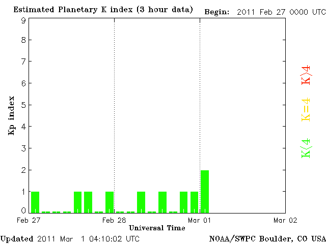
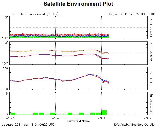
The sun has been unusually quiet during the most recent minimum of its 11-year solar cycle, but it now activity appears to be picking up. During the periods of greatest solar activity, conditions in the ionosphere can change significantly with time and position, affecting GPS accuracy. WAAS can correct for this to a certain degree, but unless you live very close to a WAAS station, there will be some additional positional uncertainty in your GPS measurements. The National Weather Service’s Space Weather Prediction Center offers info and forecasts of current and upcoming solar weather conditions. Pay special attention to the Satellite Environment Plot, which shows conditions at the geosynchronous orbit elevation (about 23,000 miles); while GPS satellites are in a lower orbit at around 12,000 miles, they will likely see a similar environment.

sep

In particular, watch the Kp (planetary index):

Kp

When Kp shoots up above 4, ionospheric conditions are likely to become less uniform, potentially leading to GPS accuracy degradation. If it gets really high, that’s the time to look for aurora at night, as well as possible disruptions in telecommunications and the power grid.

Trivia note: The Space Weather Prediction Center was one of the earliest sites on the World Wide Web.


How The FCC Plans To Destroy GPS – A Simple Explanation

Cross-posted at the AndroGeoid site.

If anyone had told me three months ago that a company was going to propose a system that would fully disable GPS in areas that cover most of the population of the US, I would have ignored them. If someone told me two months ago that the FCC would give this proposal serious consideration, I would have laughed. If someone had told me a month ago that the US Federal Communications Commission  would actually approve this scheme, I would have considered them crazy. And yet, that’s exactly what’s happened; the FCC has given conditional approval to LightSquared’s 4G LTE proposal (PDF link) . If implemented as planned, all current GPS receivers will no longer operate correctly in areas covered by their system, which include the overwhelming majority of the US population. I wish I were kidding, but I’m not. There’s a lot of technical jargon used in discussing this issue, so in this post I thought I’d try to explain the issues with a somewhat less technical, and hopefully more accessible approach. Technical nitpickers may see some oversimplification, for which I apologize … not at all.

At their most basic level, GPS receivers are pretty close to FM radios.  So to explain some of these principal issues behind the GPS problem in understandable terms, I’ll use the basics of FM radio broadcasting. To tune in an FM radio station, you turn your radio’s dial or push the buttons until the receiving frequency of the radio is set to that of the station: 89.5, 101.7, 104.1, and so on. Those numbers refer to the number of cycles per second of the frequency in millions, so that 101.7 is a radio signal operating at 101.7 million cycles per second, abbreviated as 101.7 MegaHertz (MHz) for short. But that’s just the main frequency, sometimes referred to as the central “carrier wave”; receiving a signal at just at frequency wouldn’t give you any signal information, like music/talk/news. To encode that signal, the frequency of that carrier wave is varied, or “modulated”, by the signal; your radio then monitors those variations in frequency around the central carrier wave’s frequency, and then converts them back to the original signal, music/talk/news. Frequency being modulated = Frequency Modulation = FM.

If you had two stations broadcasting in the same area on the same frequency, they would interfere with each other, making both of them unlistenable. If the frequency is only slightly different, they will also interfere with each other. To prevent this, the FCC licenses broadcasters to transmit on a specific frequency, and also makes sure that the frequencies are far enough apart so that one station’s broadcasts won’t interfere with another station. In the original days of FM, the minimum spacing for FM frequencies was 800 thousand cycles per second (800 KiloHertz or KHz, 0.8 MHz); so if one station was at 90.1 MHz, the closest frequencies allowable to that station would be 89.3 MHz and 90.9 MHz, offset 0.8 MHz up and down from the center one.

With time, the FCC has loosened that frequency spacing requirement up a bit,  taking into account factors like improved FM radio technology, the broadcast power of the station, and the distance from other stations assigned the same frequency. For the most part, the system works, but  you’ve probably experienced occasions when you’ve been listening to one FM station, only to have a second signal cut in and interfere with the first station’s signal. This is especially noticeable if you drive right by an FM radio broadcast antenna; the signal from that station can be so strong, it wipes out reception from any stations that are even marginally close to it in frequency. Because a station requires about 150 KHz of frequency modulation bandwidth to carry its signal, the FCC has also mandated that all standard FM tuning signals need to be at least 200 KHz apart; that’s why your FM tuner jumps from 100.1 to 100.3 to 100.5, bypassing 100.2, 100.4; those frequencies need to be kept free to make sure stations don’t “step” on each other’s signals.

OK, so back to GPS. While GPS doesn’t technically use frequency modulation, it uses a closely-related system called “phase modulation“, which also relies on a carrier wave. The main signal broadcast by GPS satellites, and used by the overwhelming majority of GPS receivers for determing position, is the “L1” frequency, with the carrier wave 1.57542 billion cycles per second (aka a GigaHertz, or GHz); including the total frequency band required for phase modulation, the range is 1.559 GHz  to 1.610 GHz. Phase modulation is used to transmit digital information with pulses 1-millionth of a second wide  from the satellites to your GPS receiver; the receiver takes this data from multiple satellites, and uses it to calculate your position. This frequency was defined in the late 1970s, and has been used continuously for GPS operations since the system went operation early in the 1990s, twenty years now. This frequency band is also part of a larger range of frequencies designated for use in satellite broadcasting. As with FM radio, you need to separate the frequency bands far enough apart so that the signals don’t interfere with each other; you also need to make sure that a signal at one frequency isn’t broadcast at such a high power that it will interfere with signals broadcast at neighboring frequencies. The latter isn’t usually a problem – the signal strength from satellites 12,000 or 23,000 miles above the earth is usually so low that interference between adjacent frequency bands is infrequent.

So, enter LightSquared. LightSquared wants to build a high-speed wireless broadband network on the cheap. Problem is, the FCC holds regular auctions for frequency space, with all the big wireless players (Verizon, ATT, Cingular, Google) bidding billions of dollars for this frequency space to carry their traffic; a smaller company like LightSquared can’t compete financially. But LightSquared came up with several clever workarounds to get past this issue. Satellite frequencies are also regulated and auctioned by the FCC, but they usually go for prices far lower than terrestrial frequency space. LightSquared acquired a small satellite company called SkyTerra that already owned frequency rights for 1.525 GHz to 1.559 GHz, directly adjacent to the frequency band designated for GPS. They then announced plans to develop a satellite-based Internet access service using those frequencies. Satellite signals by themselves would be so weak, that Internet speeds would likely be limited to no more than a few megabits per second, comparable to current 3G wireless network speeds. But FCC regulations have a loophole that allows satellite services to broadcast stronger signals terrestrially to supplement satellite coverage in those areas where coverage might be weak. This terrestrial broadcast signal can be as strong as the FCC allows, and is covered by the satellite auction price paid by the licensee.

So LightSquared announces a “satellite Internet access” service, but one supplemented by free use of terrestrial transmitters. But these terrestrial transmitters aren’t intended merely to fill in gaps in satellite coverage; these are high-power transmitters that allow LightSquared to offer the equivalent of 4G wireless Internet speeds (up to 100 Mbps), without paying for terrestrial spectrum. So that’s how LightSquared plans to do high-speed wireless broadband on the cheap – they don’t have to pay for the frequency spectrum they’re using. It’s a clever use of loopholes, and one I wouldn’t have a problem with, except that they will be broadcasting at high-power at a frequency that will interfere with GPS signals to the point that GPS receivers will no longer operate correctly. And this isn’t just a few transmitters – LightSquared’s plans are to install 40,000 transmitters to cover areas that contain most of the US population.

This GPS interference isn’t just a hypothesis. Members of the US GPS Industry Council, Trimble and Garmin met with the FCC on January 19th to present and discuss Garmin’s tests of the LightSquared proposal (PDF link), and its potential for interference with GPS receivers. Garmin used LightSquared’s own proposed transmitter power levels to evaluate the effects of this transmitters on an automotive GPS (Garmin nuvi 265W) and an avionic GPS (GNS430W). Here are screen captures summarizing the effects of the LightSquared transmitters on GPS receiver performance at different distances:
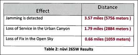
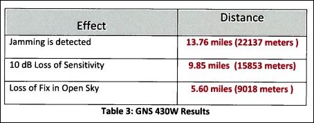
nuvi

GNS

If you get within 0.66 miles of a LightSquared transmitter in open conditions, you’ll lose your position fix with the automotive nuvi 265W, further away in a city environment like New York or Chicago. The results are even worse for the aviation GPS. The FAA has essentially discontinued support for the old LORAN electronic navigation system in favor of GPS, and now LightSquared has proposed a system that essentially disables GPS in exactly the areas aviation needs it most. Garmin’s conclusion, shared by other industry proponents:

The operation of so many high powered transmitters so close in frequency to the GPS operating frequency (1575.42 MHz) will create a disastrous interference problem to GPS receivers to the point where GPS receivers will cease to operate (complete loss of fix) when in the vicinity of these transmitters.

Other government agencies are also concerned. In a January 12th letter to the FCC, Lawrence Strickland, the head of the National Telecommunications and Information Administration (a branch of the Department of Commerce) wrote:

Grant of the LightSquared waiver would create a new interference environment and it is incumbent on the FCC to deal with the resulting interference issues before any interference occurs. Several federal agencies with vital concerns about this spectrum band, including the Departments of Defense, Transportation and Homeland Security, have informed NTIA that they believe the FCC should defer action on the LightSquared waiver until these interference concerns are satisfactorily addressed.

And yet, on January 26th, waiving many of their standard procedures, the FCC gave conditional approval to LightSquared’s proposal (PDF link). The only bone thrown to the GPS community was the requirement that LightSquared work with the GPS community to resolve these interference issues. But since LightSquared is funding the study, there are concerns about how unbiased the results will be. Unless you can change the laws of physics, and principles of electrical engineering, you can’t resolve this problem directly with existing GPS equipment as-is. LightSpeed acknowledged as much when they stated that they saw the main purpose of this joint effort as seeing how to modify GPS equipment to implement “filtering so that they don’t look into our band”. There are only two ways to implement this:

  • Retrofit current GPS equipment with improved electronics; possible but expensive for high-end equipment, impossible at a reasonable cost for consumer-grade equipment
  • Replace all current incompatible GPS receivers with new ones that have improved filtering. While the marginal cost increase on a GPS receiver is likely to be low, the requirement that you have to replace the entire unit will make this staggeringly expensive. Every GPS receiver (automotive, aviation, handheld, mobile phone) would need to be replaced.

There’s additional fodder for conspiracy theorists as well. LightSquared filed its proposal on November 18, 2010, right before Thanksgiving. The FCC fast-tracked its proposal, and limited the comment period to December 2-9, 2010, over the objections of the GPS industry and other opponents. In approving LightSquared’s proposal, they acknowledge waiving some of their requirements (PDF link). And for the real conspiracy fans, the principals behind LightSquared may have political connections deep inside the current adminstration (PDF link). In normal circumstances, I would dismiss all this as nonsense, but the FCC’s decision is blatantly crazy, I have to wonder.

If it weren’t for its detrimental consequences on GPS, I’d think that LightSquared’s system would be a great idea – high-speed wireless Internet access in most populated places, and lower-speed access anywhere in the world by satellite. And if the FCC wants to propose regulations requiring better frequency band filtering in GPS receivers, and other types of satellite-band-based systems, to allow exactly these kind of systems to be developed in the future, I could get on board with that as well. But it should be up to LightSquared to prove that their system won’t interfere with GPS the way it is right now. GPS is the established system – twenty years of operation, hundreds of millions of receivers, uncountable numbers of applications. If LightSquared interferes with GPS, it should be required either to fix the problem itself, or be denied permission to function. That the FCC would even consider LightSquared’s proposal without modification, much less approve it, is astonishing.

If you’re interested in letting the government know how you feel, GPS World has a page on how to contact the relevant members of the House and Senate. GPS World is also the go-to source for coverage of this issue:

Addendum: A great article at InsideGNSS.

And a HT to GPS Tracklog Waypoints for the original link to GPS World.


Free GIS Data Acquisition And DisplayTool For The iPad

Don’t have an iPad, and my head is thoroughly into Android, so when I got a comment informing me about Corvallis Microtechnology’s new free iPad application iCMTGIS (iTunes link here), I almost ignored it. Big mistake – this looks like a pretty sweet field GIS data acquisition tool for the iPad!

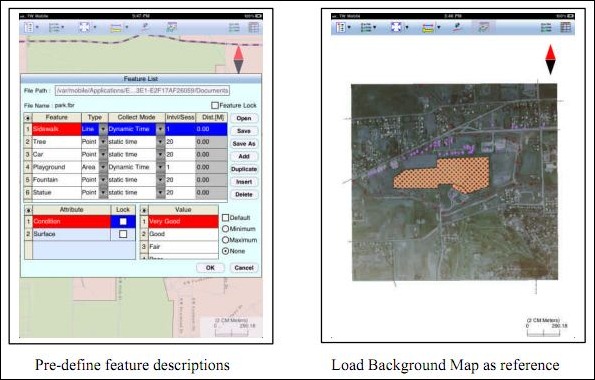
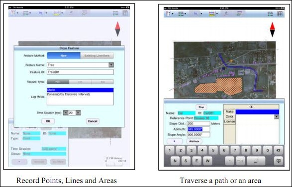
  • Point, line and area data acquisition, either by GPS, manual entry, or distance/angle value entry
  • Full attribute entry capabilities, including setting up hierarchical data entry forms
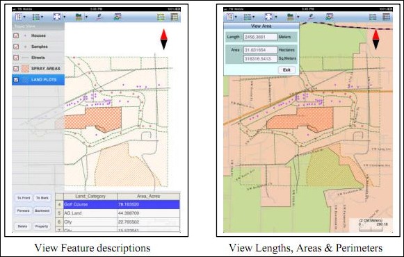
  • Attribute query on-screen
  • Multiple data layers
  • Measure/calculate distances and area
  • Use aerial imagery as backgrounds
  • Import shapefile data
  • Export data in shapefile format, or PMP format for use with Corvallis Microtechnology’s own proprietary GIS programs

A few screen captures from their PDF brochure:

cmt1

cmt2

cmt3

May not have all the features of an ArcPad or TerraSync, but this sure looks a  hell of a lot easier to use! Almost makes me wish I had an iPad to try it out on; if you give it a spin, leave a note in the Comments section. I have to hope and believe that similar apps will make it on the Android platform in the not-too-distant future.


Scrub Geotagging Data From Photographs With Geotag Security

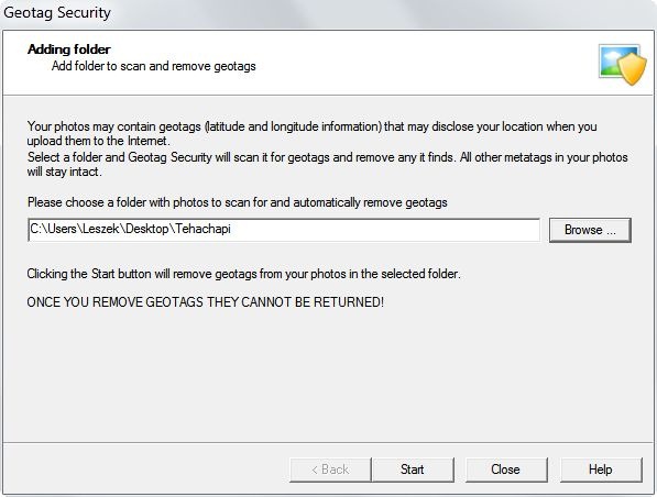
Many smartphones come with geotagging turned on as a default; if the phone has a good position fix from GPS or cell tower data, it will embed these coordinates into the EXIF header of the photograph.This is my preferred setting, but there are times when I want to remove this data, to protect the location where a photo was take. The free Windows program Geotag Security will remove the embedded coordinate geotagging data from all photos in a folder, while leaving the other EXIF data (date, time, exposure info, camera, focal length, etc.) untouched. Just select the folder with the photos you want to have scrubbed, and it does the job automatically:

geotagsecurity

As the caution above indicates, once the coordinate geotags are removed, they’re gone for good. So if you want to preserve the original geotagging data somewhere, you should first make a copy of the folder with your photos, and scrub the geotag data only out of the copy.

A $20 Pro version of Geotag Security is available that will monitor folders, and automatically scrub their geotagging data as you download them from your phone or camera.

Via Lifehacker.

Note: The Android app GeoEraser can also remove geotag data from a photo, but creates a new scrubbed photo, keeping the original unchanged.


Satellite Tracks And Visibility In Google Maps

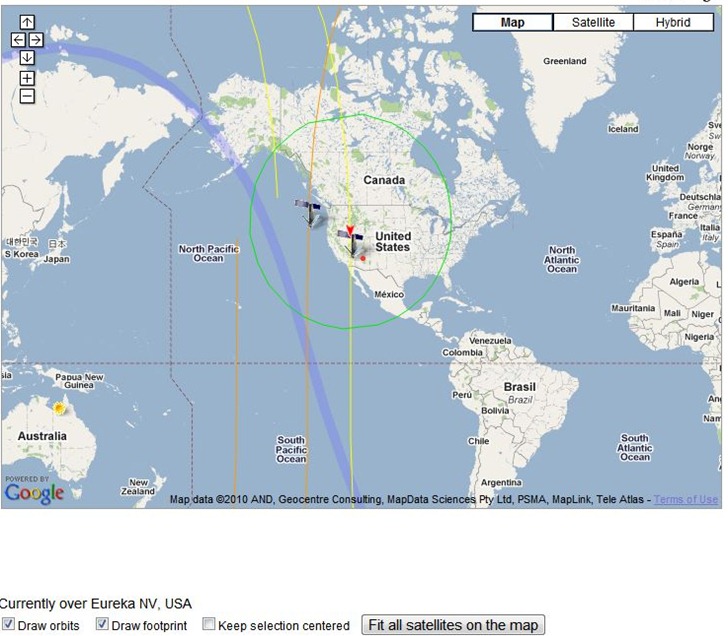
The Live Real Time Satellite Tracking page lets you select a satellite, or groups of satellites, and plot their position in a Google Maps interface. You can select all types of a particular satellite currently visible from your location, and plot them along with the satellite’s visibility footprint (Iridium satellites here):

iridium

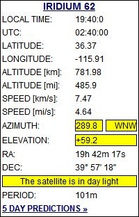
The graphical view updates in real-time, so you can see the satellite’s position change. A display shows you the current visibility parameters for the selected satellite:

2010-11-06_194014

You can select from lists of satellites with a single click:

2010-11-06_193947

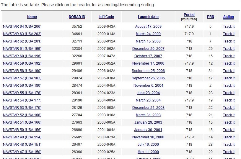
And then select from a list of satellites (GPS operational here) to choose which one to track.

2010-11-06_194128

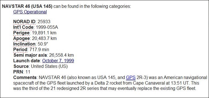
Clicking on the satellite name brings up additional info about the satellite:

navstar

With the “Up In Your Sky” links, you’ll have the option of selecting multiple satellites, including all of them in a particular category.