Not too long ago, Magellan announced that they had upgraded the firmware and PC software for their Triton line of handheld GPS receivers, noted for their ability to display raster imagery, and offered to send out review units to interested people. There are several free utilities for the Triton series that I’d been interested in posting on, plus I’d always been interested in the raster map capabilities of these units. I requested a review unit, and they were good enough to send a Triton 2000 to me a few weeks ago. I’ve had the opportunity to evaluate it in both recreational and field work environments, comparing it with my current GPS receiver of choice (Garmin 60Cx), and thought I’d post a review of the GPS unit itself before posting about free utilities.
When first announced, the Triton units got quite a bit of attention for their ability to display raster imagery, specifically National Geographic versions of USGS topo maps. It’s fair to say that the initial product release did not go well; reports of units freezing up and crashing were common, and huge numbers of them were returned. It’s also fair to say that many of these initial problems have been fixed; if you look at comments on the Amazon product pages, you’ll see many negative comments dating from the Triton release date (January 2008), and more positive comments recently.
There are 6 Triton models currently available, all of which use Windows Mobile as the OS, but conceal it under a more conventional GPS user interface. I would suggest that you not consider the Triton 300 model, as it offers only limited onboard memory for maps, and doesn’t take SD memory expansion cards. The remaining models do take SD cards; while Magellan says the max is 2 GB, some have reported success using cards up to 16 GB in size. These Triton models include:
Magellan Triton 400: 266 MHz ARM processor, 2.2” diagonal screen, SD slot
Magellan Triton 500: Like the 400, but adds an electronic compass and barometer
Magellan Triton 1500: 400 MHz ARM processor, 2.7” diagonal touch-screen, SD slot, voice recorder, MP3 player (?!), flashlight, external antenna connector
Magellan Triton 2000: like the 1500, but adds an electronic compass, barometer, and 2 MP camera
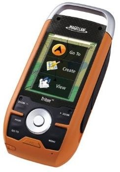
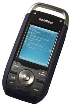
The 1500/2000 units are almost identical in appearance to the professional-grade Magellan MobileMapper 6; the 2000 has essentially the same hardware specs, down to the camera and processor speed. Here are images of both (Triton 2000 is orange, MobileMapper is black):
 |
 |
The 400/500 units are somewhat similar in appearance, but smaller in size.
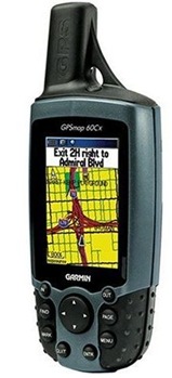
In this review, I’ll be comparing the Triton to my Garmin 60Cx. The Garmin 60Cx, along with its brother unit the 60CSx (which adds a compass and barometer), may well be one of the most popular handheld GPS units ever released. Almost three years after it was first introduced, the 60CSx usually ranks 1st or 2nd at Amazon in handheld GPS sales; combine its sales with the 60Cx, and it’s probably #1 all the time. I’ve read reviews of people who bought more advanced Garmin models like the Colorado or Oregon, then returned them and gotten a 60CSx instead. I’ve owned mine for about 2.5 years, and it’s never let me down. My 60Cx uses the Sirfstar III chipset, same as the Triton; newer models of the 60Cx use a different chipset. Pricewise, the 1500/2000 are only a bit more expensive than the 60Cx/60CSx, so it’s a fair comparison on that score. Here’s a pic of the Garmin:
In today’s post, I’ll be reviewing mainly the physical and software attributes of the Triton; a subsequent post will talk about its actual GPS performance in the field. But before I begin, let me start by saying that the Triton 2000 hasn’t crashed or frozen up on me yet, which has been the biggest problem reported by others in the past. And I’ve installed two firmware updates in the past month-and-a-half that added most of the features I thought were missing in the unit as received. If you have this unit, make sure you have the most recent firmware installed, and use the stand-alone firmware updater; people have reported problems with updating using Magellan’s Vantage Point software. It’s also apparently a good idea to have an SD card installed in the unit before updating the firmware.
Size And Weight: The two units are virtually identical in weight, about 0.5 lbs with 2 AA batteries installed. At 6”, the Garmin is 0.5” longer, due mostly to the helical antenna nub, and 1/4” thicker at 1.5”, the Magellan is wider, 2.5” vs 2”. The Garmin feels better in your hands than the Triton, but it’s not a big difference; the Magellan fits better into a pants pocket. Another problem with holding the Triton in your hands is that it doesn’t come with a lanyard or built-in lanyard attachment point like the Garmin, making an accidently drop more likely. There’s a ring on the battery compartment clamp that could be used to attach a lanyard, though not optimal; the metal loop on the top is a bad choice, since it contains the Triton’s antenna. One nice feature about the Magellan’s screen is that it’s slighly recessed, which offers it better protection from being scratched or broken if dropped.
Battery Life: Magellan specs Triton battery life at about 10 hours with alkaline AA batteries, and I found that to be a conservative number. Using rechargeable 2100 mAH NiMH batteries, I got about 11 hours in the field with moderate backlight use before it gave out (with the compass and barometer turned off to save power). With a 2700 mAH better, you might be able to get 14 hours or so. Magellan doesn’t recommend rechargeables, and there’s no setting in the Triton to specify them, so you’ll have to watch battery life closely. Alkaline batteries lose voltage slowly, so you’ll have plenty of advance warning; NiMH batteries keep a constant voltage till they’re almost exhausted, then the voltage drops quickly. Using the backlight is the big battery killer; with the backlight on medium setting all the time, battery life was only 5 hours. If you don’t need to have the Triton on all the time, putting it into Suspend mode (power button plus the Enter button) drops power consumption down to virtually nothing; full recovery from Suspend takes only about 10-15 seconds or so. The Garmin is far superior in battery life – I get 20+ hours with rechargeables, and 25+ with alkalines.
Display: In indoor, shaded or cloudy conditions, with the backlight on, the Triton’s display is terrific. It’s only slightly larger than the Garmin (2.7” vs. 2,6” diagonal), but the resolution is higher (240×320 vs. 160×240), and the display is full-color (I’m guessing 16-bit, or 65K colors) vs. 254 colors on the Garmin. Raster maps look great on the Triton’s display, as good as on a computer monitor. And on the map display page, the Triton makes better use of the space available than the Garmin.
In sunlight conditions, though, the Triton doesn’t do that well. In full sunlight, you have to hold the Triton at just the right angle to see anything on the map page, and visibility isn’t that much better on data pages. If you turn your back on the sun so you can view it shaded, and turn the backlight on full, it’s usable but still not ideal. The Garmin 60Cx, on the other hand, has the best sunlight-viewable color display I’ve ever seen on any handheld GPS; detail and color show up very well.
User Interface: I’ve been using Garmin GPS units for about 10 years now, and am very comfortable with the user interface. So it’s difficult to be fully objective when learning to use an entirely new interface – you keep wanting it to work just like the one you’re used to. But I think I can be fair.
The Garmin has 8 front panel buttons and a rocker switch, vs. 5 buttons and a rocker on the Triton, so accessing setup and data pages is usually faster on the Garmin than the Triton. The touchscreen on the Triton helps speed up access to feature and setup screens a bit, but for the most part the interface is identical to that on non-touchscreen Triton models; Magellan would do well to offer faster access to critical screens using the touchscreen. You can select some data pages to show up when you press the “Page” button, but many useful pages aren’t offered as options. There should be pages for Waypoints, Tracks, Media (pictures and recording), Maps, and more to allow faster access, and hopefully Magellan will add those in future firmware updates. And every GPS I’ve used until now has had a one-button “man overboard” function; press the button and you get an instant waypoint. With the Triton, it takes two selections to do this.
The touchscreen can speed things up a bit onscreen by letting you tap on a button rather than having to select it with the rocker switch and press enter. It’s pretty responsive to touch with either finger or the built-in stylus, about the size of a Swiss Army knife toothpick; you probably will lose the one that comes installed, but the unit comes with spares. Touching the screen with your finger tends to leave smudges that can kill screen visibility, especially in sunlight, so it’s best to stick with either the stylus or your fingernail. You can pan the screen by dragging across it, but I have to think this is a bad idea for an outdoor unit – get a bit of dirt under your stylus as you drag, and you’ll put a scratch into the screen (a screen protector would help for this).
Computer interface: The Triton uses a custom USB connection cable which you have to screw onto the back of the unit; this is retarded. Every other GPS with a USB interface, like my Garmin, uses a standard mini-USB cable that you can buy for a buck or two. I’ve seen the Magellan cable listed for as much as $70 (?!), though if you look you should be able to find one for about $20. It’s also only USB 1.1, which is 40 times slower than USB 2.0, and results in horrendously long upload times for map data. The Garmin also only has USB 1.1, but its software lets you upload maps and data to a microSD card in a USB 2.0 reader, which speeds up map uploads dramatically. You can’t use Magellan software to upload directly to an SD card in a high-speed reader, but you can drag and drop map files directly in the Windows File Explorer into a folder on an SD card.
On the plus side for the Triton, you can set the USB connection to act as a serial NMEA connection, useful for hooking up to programs that don’t support the Garmin USB communication protocol. This works fine as long as you set the NMEA Option setting to anything except “Off”, the default setting, which results in no NMEA communication at all. This isn’t particularly well-documented.
Proprietary software: The Triton comes with Vantage Point software for uploading/downloading maps, data, photos and other files. The best I can say about VP is that it’s functional, and sort of does what you need it to do; plus, it’s free for all Triton owners. But the interface is mediocre, as are its abilities to create, download and manage waypoint and track data. It has supposedly been improved since first release, and I can only hope that they will continue to work on it. Garmin’s MapSource came free with my Garmin, and also comes with any Garmin mapset you purchase. MapSource is far superior for managing data for upload or download to/from your Garmin GPS unit. Oh, and Mac users should forget completely about the Triton – there’s no Mac software available, period. Garmin Mac software isn’t great, but it is there.
Third-party software: Virtually all third-party programs for managing GPS data can download and upload to any Garmin units; examples of these include GPSTrackMaker, GPSBabel, EasyGPS, ExpertGPS, USAPhotoMaps, OziExplorer and many others. None of these programs support Magellan, and that’s because Magellan has apparently refused to release documentation about the Triton’s USB interface protocols. Even if Vantage Point were the greatest GPS software in the world, this would be a bad idea; since Vantage Point isn’t that great, this situation is intolerable. Magellan needs to immediately release interface documentation that will let other programs communicate with Tritons; if Garmin doesn’t have a problem with doing that, neither should Magellan.
Maps: I’ll break this into two map types, raster and vector.
Raster
Raster maps are bitmaps, like scanned maps. Garmins have a very limited ability to display some of those using programs like Moagu, BMaP2MP or MapWel, but with severe limitations in draw speed and resolution. Even so, if I have a choice between viewing the fast searchable vector topo maps or slow raster USGS topo maps on my Garmin 60Cx, I’ll choose the raster maps every time – they’re just easier to work with for navigation.
The big selling point of the Magellan Triton series when introduced was their ability to load and display National Geographic Topo maps, modified USGS topo quads. But what many early Triton buyers found was that this didn’t work very well. The Topo software was buggy, the interface stunk, and uploads weren’t always successful. Some of these issues have been fixed, but Topo’s still not a very good program to work with. A bigger problem is that the maps as displayed on the Triton don’t always work well in the field. The Triton 2000 comes with sample topo maps for Yosemite, and these NG Topo maps have terrain shading, which looks great on a computer monitor or printed out. Unfortunately, on the Triton screen, the shading interferes with the ability to view map detail, especially under sunlight conditions. Garmin vector maps for the Oregon and Colorado also have that problem, but at least on those units you can turn the shading off; you can’t on the NG maps. Next, the uploaded topos have clear compression artifacting, which further compromises map detail. Finally, you can’t view the maps at a zoom level higher than 500-ft., and that’s not good enough.
Cost is also an issue. A full set of topos for Arizona costs about $90, with other states available for similar amounts (make sure you buy a recent version that supports the Triton, as older versions that don’t are still available). You can also buy maps a la carte, but the costs of this can add up quickly. deLorme tried a similar a la carte map pricing system with raster maps for their PN-20 GPS units, and quickly dumped that with their PN-40 and PN-30 units in favor of a unlimited download policy for a yearly $30 subscription fee. If they were smart, Magellan and National Geographic would get together and switch to this subscription policy as quickly as possible.
Fortunately, there’s now another option. The map format for raster Triton maps has been reverse-engineered, and you can now convert your own raster imagery into Triton-compatible format, and upload it to a Triton unit. It’s a surprisingly easy process, too. I’ll cover several of those programs in upcoming posts, but I’ll say it now:
Custom Raster Maps On The Magellan Triton GPS Rock!!!!
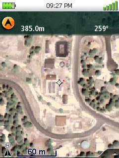
I’ve expressed some reservations about the Triton in the review up to now, but the ability to put any raster map you want on a Triton makes most of its drawbacks tolerable. I’ve put custom USGS topos and color aerial imagery on the Triton, and they look spectacular (highest resolution is about 1 meter per pixel). Here’s a topo map screenshot; it actually looks better in real life than here:

Here’s a one-meter color aerial photo:
And if you like terrain-shaded topo maps, you can create your own:
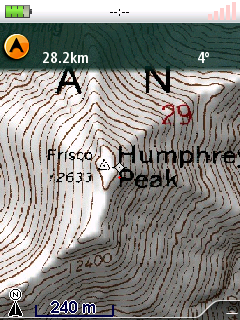
What’s more, unlike other units with raster map ability, there’s not a major performance hit – zooming and panning of this imagery is very fast. This ability helps even out the discrepancy in map availability between Garmin and Magellan. You can now take any raster map available in digital format, like those at the USGS Seamless Server, and convert it for use on the Triton. For vector data like shapefiles, you can load it into a GIS viewer or editor, make the map look whatever way you like, export it in raster format and then load it onto the Triton. If you do a lot of fieldwork with paper maps that have both vector data and raster data combined, the two work great together; print out a map on paper for large-scale views, and upload a digital version to the Triton. For field workers, hikers and backpackers, geocachers, anyone who works outdoors, this capability is fantastic. Without it, even with the National Geographic Topo maps, the Triton series would be doomed to be an also-ran in the GPS competition.
Vector
The basemap that comes with the Triton is better than any I’ve seen with any Garmin unit. For example, in the Phoenix area, the Triton show major avenues and streets, while the Garmin only shows highways. But beyond that, the Garmin is far superior for vector maps than the Triton. Any Garmin map purchased in the past 10 years that isn’t locked to a serial number will work on any Garmin unit through Mapsource; in contrast, older Magellan MapSend maps have to be specially processed to work with Vantage Point and Triton. Garmin sells more types of maps than Magellan, and comparable mapsets are cheaper from Garmin than Magellan.
There’s also a huge community of Garmin mapmakers that are producing free custom mapsets for the Garmin. There are many programs, free and shareware, to help you create these maps, like GPSMapEdit, cgpsmapper, Moagu, MapWel, MapDekode, MapMan and more. While the process is a bit technical, with some experience you can produce maps comparable in quality to commercially-available ones; search this blog for “Garmin maps”, or check out those at the GPS File Depot, for great examples of those. And while Garmin doesn’t officially endorse this activity, I know from what others have told me that unofficially they will point people towards these maps as a useful resource when Garmin doesn’t have a comparable product. And while they could have shut down this activity very easily, either with legal action or by modifying the GPS firmware to make custom maps incompatible, they haven’t.
There are custom Magellan vector maps out there, but the community is smaller, and the toolset is limited. They are usually made with older versions of Magellan’s MobileMapper Office software that are technically not freely distributable, and are hard to find. The Maps4Me site has a limited selection, and a Google Search will produce a few more. They’re perfectly decent maps, there’s just not a lot of them. You can always convert vector files like shapefiles or KML files into GPX format (search this blog for posts on this), and then upload the vector data to the Triton unit. But unlike vector maps, the total amount of data you can upload this way to a Triton is limited. Finally, there’s no auto-routing or address lookup capability in the Triton units, unlike many Garmin outdoor models.
If Magellan were smart, they would release a stripped-down older version of MobileMapper Office that would let you make your own maps; that would go a long way to towards reducing the disparity in map availablity. And since deLorme includes detailed topo maps with their PN series, and Garmin has built-in topo maps for many of its Colorado and Oregon units, Magellan would do well to include topographic maps with its Triton units as well. Still, the ability to upload custom raster maps that can include vector data overlays balances this out to a great degree, and for me arguably tips the scale in favor of the Triton.
Other features:
- Both the Garmin and Triton have external antenna ports; for reasons I’ll go into in the second part of this review, this is more important for the Triton than the Garmin.
- The Triton has a electronic compass; while my 60CX doesn’t have one, the 60CSx does and I’ve played with it a bit. The Garmin compass requires you to hold the unit horizontal for best results, while the Triton has a tri-axial compass that works at any angle. For both units, though, I just don’t find either compass good enough for give more than a rough heading. For that, it’s faster and easier to use a $2 discount store compass (or, for me, a $36 Suunto compass). Turning off the Triton compass saves on power, and I did that almost immediately.
- The Triton and 60CSx both have barometers. On the Garmin, you can use this for altitude measurements and profiles, or for weather prediction. The Triton only gives you the current pressure – no altitude or weather forecasting. In short, fairly useless, and I turned it off to save power as well
- The Triton has a built-in MP3 player, but given its limited battery life, and how small (and cheap) dedicated MP3 players are, this is pretty worthless.
- The Triton’s voice recorder/player, on the other hand, can be extremely handy for taking voice notes in the field. And you can associate a voice note either with a pre-existing waypoint, or create a waypoint on the spot to associate it with. A very nice feature.
- The Triton’s built-in camera is only 2 MP max (1600 x 1200, with the option for lower resolutions), with no focus settings, so don’t expect too much. But for quick and dirty field data recording, it’s not bad:
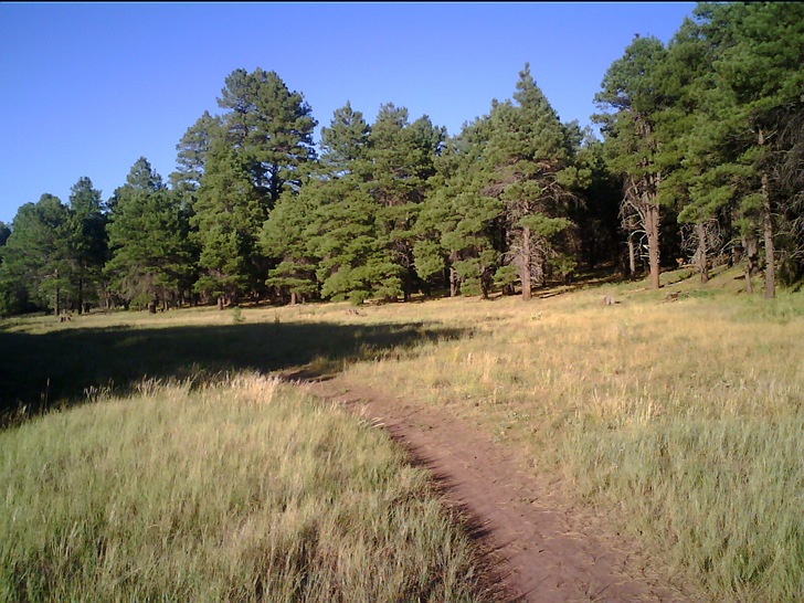
Lens is fixed focus, but can get reasonably sharp images from infinity to about 6 inches away; up to 3x digital zoom, but the quality using that is poor. As with the voice recordings, you can attach a photo to a waypoint, but the Triton also automatically geotags the photo with the current location as well. One odd missing feature is that with the electronic compass on, the direction you’re taking the photo in isn’t included in the geotag; this would be a very useful feature to add.
Second part of the review will look at GPS signal acquisition, ease of use in recording data, and positional accuracy.