Many recent Garmin GPS mapping units (like the 60Cx and 76Cx units) have a maximum limit of 2025 map sections that you can upload directly to the unit, and you’ll get an error message if you try to exceed the limit. If you try uploading more than 2025 to a microSD card in a card reader, you won’t get an error message, but the GPSr unit will still not be able to display the data from more than 2025 maps after you put the microSD card back into it. This wasn’t such a big deal when memory was expensive, and 128 MB of memory was considered a lot – there was no way you come close to that 2025 limit with that little memory. But these days you can get a 2 GB microSD card for a Garmin unit for less than $20, and you could easily fill such a card with more than 2025 maps if that were possible.
Probably the biggest offender in terms of total number of map sections are the Garmin Topo series. While the Garmin MetroGuide and City Navigator mapsets have less than 1500 map sections, the original Garmin Topo series has 2622 sections covering the Western US, 2565 covering the East, and another 1452 covering Alaska and Hawaii (6639 in total). In terms of total memory, though, they could all easily fit on a single 2 GB card with about 700 MB of extra room to spare. A previous post covered some basic tricks you could do with microSD cards to sort of “stretch” that limit, but there’s now an alternative for the old US Topo maps that solves this problem.
R.W. Smith (who also created some excellent Garmin maps for areas such as the Caribbean and Antarctica) has created a tool called CombineMaps that will merge together groups of smaller topo map sections into larger ones, creating 370 combined maps to replace the 6639 original ones. He describes it in this online post, and he has complete directions (including links to the downloads) here. I won’t re-hash the instructions, since they’re clear to follow, but having tried it, I have a few notes:
- You need to already own the original Garmin US Topo maps (no longer sold; you might find a cheap copy on eBay), not the more recent Garmin Topo 2008 maps. While this process could be used on those maps as well, the author hasn’t created a set of configuration files yet for that product, though he outlines the basic process for doing so in his instructions.
- The data from the Topo CDs needs to have been copied onto your hard drive. If you haven’t already done that, you should, even if you don’t use this process. Copying all the files from all three Topo CDs into a single folder on your hard drive, and then installing from there, lets MapSource access the data directly from the hard drive – no more CD disk-swapping.
- The first step of this process takes a long time. The text says that it took him 36 hours on his computer, and it took 48 hours on my older system. And I wouldn’t try it with 512 MB of RAM, since disk access and cache swapping will slow things down a lot; I’d say 1 GB is a better number. Later steps went a lot faster
- Always give the full pathname for a file, and enclose it in double-quotes.
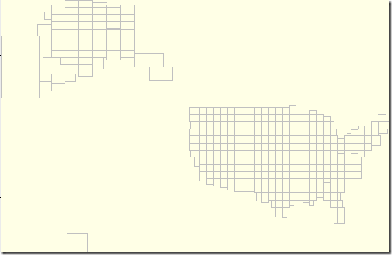
- The initial process will install the maps into MapSource, but the overview map won’t have any details at lower zoom levels:
- The instructions tell you how to supposedly create a more detailed map for these zoom levels, but when I followed that process, MapSource would crash every time I tried to start up the program. If this happens to you, don’t panic. Just delete the “US Topo.img” file you created in the last step of the process, re-name “US Topo.mp.backup” to “US Topo.mp”, and run cgpsmapper with this file again to re-create the “US Topo.img” file that generates the view above. If worst comes to worst, running the “US Topo UnInstall.reg” file will fix the crashing problem, and you can then go back through all the previous steps, but stop short at creating a detail zoom map.
- During the long process of combining map segments, I was a little concerned about the number of error message that were coming up, especially those that said that data was being skipped because it was wrong. But comparing the original Topo map data:
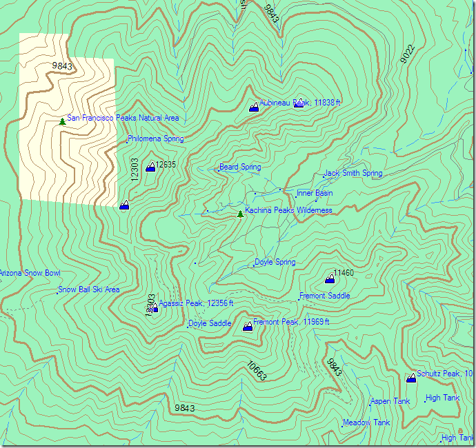
with the data from the new combined map segments:
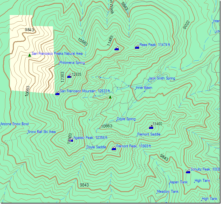
I couldn’t find any major differences. Some of the label positions were shifted, while some labels didn’t show up at all in one view but did in another.
As an added bonus, with the fewer number of sections, MapSource is able to index all the sections and assemble them a lot more quickly than it could with a larger number of small sections in the original dataset.


COOL
This info was very useful . I have tried this using a Sandisk 8GB Micro SDHC card and found that it works on my
Garmin 60 CSX .