blankblank blank


Mapping Zip And Area Code Boundaries, And More


The USNaviguide website has an assortment of Google-Maps-based services for mapping the boundaries of various geographic parameters:

Zip Code: Enter a 5-digit zip code, or the first three digits of a zip code, and get a map of the area covered by that zip code. Or click on the map, and get a map of the all the zip codes in that area, with a placemark at the location you clicked on with the zip code for that area in the info bubble:

clickzips

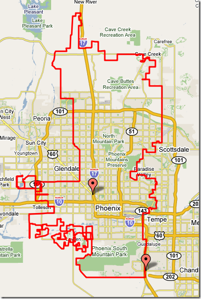
City/town boundaries: Enter a zip code, or click on the map, and get the boundary of the city/town jurisdiction for that area where appropriate:

phoenix

County/FIPSCSA: Enter a zipcode, or click on a spot, and get a map similar to the one above for either a county or a FIPS (Federal Information Processing Standard) Core-Based Statistical Area, with a placemark near the center of the polygon with the relevant information, including code numbers.

There is also a US geocoders (get a latitude/longitude for an address), and a reverse geocoder (enter the lat/long or click on an address, and get back the closest addresses to a point).

The related Maps.Huge.Info site has links to most of the above services, but also a few more as well:

  • US telephone area code maps
  • Plotting zip codes by line boundary instead of overlay map (as at the top)
  • Australian post codes
  • A zip+4-based reverse geocoder

Finally, there’s a page of the free PERL code they use for converting a polygon of points into a Google Maps polygon.

Via GoogleMapsMania.

Other posts in the Google Maps Tools series

  1. Coordinate Data From Google Maps
  2. Reverse Address Geocoding With Google Maps
  3. Converting Google Maps Search Results To GPX
  4. Coordinate, Elevation, Distance And More In Google Maps
  5. Google Maps "My Maps" Features
  6. Measuring Elevation, Distance And Area In Google Maps
  7. Creating GPS Routes In Google Maps
  8. Thematic Polygon Shapefile Display In Google Maps
  9. Using The Google Maps Interface To Display General Maps And Images
  10. Heat Mapping In Google Maps
  11. Elevation Profile In Google Maps
  12. Embed Google Maps "My Maps" On Your Web Page
  13. Customizing Google Maps Markers
  14. Two Fun Cartographic Google Maps Tools
  15. Simple Guide To Embedding Google Maps "My Maps" On Your Own Webpage
  16. Another Google Maps Geocoder/Reverse Geocoder
  17. Drawing Lines Between Points In Google Maps, Straight And Great Circle
  18. Convert A Google Maps Point To Multiple Text Geographic Formats
  19. Meet Your Friends Halfway
  20. Plotting Swivel Data In Google Maps
  21. Meet Your Friends Halfway II
  22. Geographic Midpoint Calculator
  23. GIS-Like Functionality In Google Maps With ZeeMaps
  24. Creating GPS Waypoints Online From The USGS Geographic Names Information System (GNIS)
  25. MapMyRide.com
  26. Exporting KML Data From Google Maps MyMaps To A GPS
  27. Advanced Tool For Embedding Google Maps MyMaps On Your Website
  28. Draw/Label On Google Maps, And Generate GPX/KML/Embeddable Maps
  29. Another Way To Create Embeddable Google Maps With KML Data
  30. Documenting A Journey With Maptales
  31. Plot A Coordinate Position On Different Map Pages
  32. Worldwide Reverse Geocoding With Google Maps
  33. Google Maps Shaded Relief Site Updates
  34. Digipoint 2: Export Of Google Maps Points In Multiple Formats, And Elevation Data
  35. Google Maps Line Tool Now Supports Distance Measurement
  36. Geographically-Linked Video With VeoGeo
  37. Recent Google Maps Tools
  38. Google Maps Mapplets From Zonums Software
  39. Maximize Google Maps With Google Maps Max
  40. Mapping Zip And Area Code Boundaries, And More
  41. Altitudes And Terrain Profiles In Google Maps
  42. “Friendly” URLs To Address Maps
  43. Quick Zip Code Information
  44. Simple Online Form For Creating An Embeddable Google Map
  45. Embed Synchronized Google/Microsoft Virtual Earth Maps On Your Website/Blog
  46. Worldwide Contour Lines In Google Maps’ Terrain View
  47. Plot Gazetteer Features In A Google Maps Interface
  48. Antipodes Map

Looking for something else? Enter some keywords below, then click "Search".
"This site" searches Free Geography Tools; "Web" searches the Internet using Google.


1 Response to “Mapping Zip And Area Code Boundaries, And More”


  1. 1 US zip code map

    I would recommend http://www.zipcodesmapped.com/ for any US zip code map.
    You can use this to find any US zip code maps. You can search by (City, State OR Zip). they have all the maps showing zip codes and major mile streets in all of the united states. The service is free. Search for five Digit Zip Code and find the Maps for all 50 states. A Free ZIP Code Finder which can do wonders for you. Zip codes

Leave a Reply


I welcome all legitimate comments. But spammers should know that my spam filters are currently blocking almost 100% of comment spam, and any that gets through the filters is immediately deleted. Don't believe me? Try posting a spam comment, and see what happens.

Powered by WP Hashcash