Some image formats, like JPG and BMP, don’t support embedding of georeferencing data, so they require a worldfile to georeference them in GIS software. It can be inconvenient to move and keep track of two files instead of one, so it’s often useful to convert the original image into a format that supports embedded geodata, and then use the worldfile data to embed the appropriate georeferencing data into it. The TatukGIS Viewer is able to do that; it can open a raster image file in several different formats (JPG, BMP, PNG, TIF, ECW, SID, JP2), use the worldfile to georeference it, and then export it to the GeoTiff format with the georeferencing data embedded in it.
1. Open the image with the worldfile in the TatukGIS Viewer program (the Add Layer command)
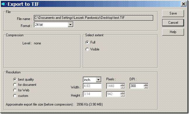
2. Choose File => Export Image from the menu
3. Select Tag Image File Format (*.tif) as the desired export format, and enter the filename to save under
4. In the Export to TIF window that comes up, you can modify the bit depth of the image to reduce the colors/filesize of the image; you can also change the image size as well, and choose whether to export the whole image or just what’s visible on screen. TatukGIS will stamp a label on the bottom of the image, something to keep in mind when exporting part of the image.
When you click the “Save” button, the image will be saved as a GeoTiff, with the coordinate georeferencing data embedded in it. Worldfiles don’t contain coordinate system or datum information, so that isn’t included in the georeferencing data embedded in the GeoTiff file. Also written is a *.tfw worldfile for the newly-created TIFF image, useful if the GIS program you’re using doesn’t read embedded GeoTiff coordinate data.
You can also go in the opposite direction: open an image file with embedded georeferencing data (e.g.GeoTiff, MRSid or ECW file), then convert it into a image format that doesn’t support embedded data (JPG, BMP and PNG), along with a worldfile that can used by other programs to georeference the image.
The TatukGIS Viewer is easy to use, flexible in export options like resolution and bit depth, and accepts a wide variety of raster images for export in georeferenced format. The biggest drawbacks are the label it stamps on the bottom of every exported image (which can be cropped off), and its inability to add coordinate system/datum information to the file. The next post in this series will talk about a program that’s less flexible and not quite as easy to use, but which doesn’t have a watermark, and has a limited ability to embed coordinate and datum information into the GeoTiff header.
I have a problem with a 1.2GB GeoTIFF file (compressed with JPEG Q4). Something is wrong in the header and I want to delete two lines of the header and then leave the rest of the file as is. The problem is when I try for instance the GDal GUI I have to first convert it to plain TIFF, then geotagg it again and then save it. When converting to plain TIF the file gets above 4GB and that does not work. So my question is: How do I edit GeoTiFF information in a TIFF-file and leaving the rest of the file without any changes? Thanks for the great blog by the way. Nice place to combine both work and spare-time hobbies :)
There will be some posts coming up soon that might offer some help for your problem.