Converting point text files to shapefiles is easy; converting sets of text coordinates describing lines and polygons, not so much. I’ve found a way to convert sets of text vertex coordinates into line and polygon shapefiles, but there are some limitations:
- The sets of vertex coordinate points need to be in the right order, i.e. all the points describing a line or a polygon need to be listed in the order they define a shape.
- You can only create a single line or single polygon at a time; if you have multiple shapes described by sets of points, you’ll have to generate the shapes one at a time and then merge all the shapefiles later on.
- No attribute data gets converted – you’ll have to enter it manually for every shape in the final product file. Fun.
The basic process is straightforward:
1. Create a CSV file with the vertex coordinates for the individual shapes. The first row should contain field names for the coordinates (e.g. Lat, Long), separated by commas. This is probably most easily done in a spreadsheet program.
2. Change the file suffix from CSV to TXT.
3. Open the file in DNRGarmin (File => Load From => File, with “Text File” as the file type).
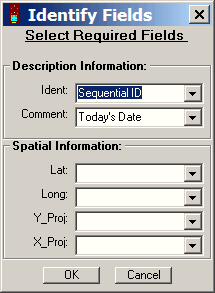
4. Specify the field names that correspond to the spatial information, and click OK.

5. Select “Track” or “Route” from the radio buttons above the data table.
6. Choose File => Save To => File; enter a filename, and select “Arc View Shapefile” as the file type.
7. In the pop-up window that shows up after you click OK, specify whether you want the point data to be converted to a line shapefile or a polygon shapefile. Click on OK, and the points will be converted to the specified shapefile type.
Converting Text/Spreadsheet Data To Line/Area Shapefiles
I was wondering, once I have created the list of LAT and Long, how do I make the polygon a specific shape (circular) and size (exactly 75 meters long)
Thank you for your help.
I would convert the lat/long list to a point shapefile, re-project it to a metric coordinate system (e.g. UTM), then create a buffer layer area shapefile for the points with the desired radius. If you don’t have a GIS capable of all those steps, MapWindow (www.mapwindow.org) has all the needed tools; do a search on this blog using “MapWindow” for more info.