An email pointed me towards two more programs for extracting and embedding worldfile data from TIF files: the listgeo and geotifcp utilities, part of the libgeotiff files available from the maptools.org site. Both of these are command-line utilities available for Windows and Unix, but there’s a GUI available for Windows called listgeo_GUI that is somewhat easier to work with. The GUI installation package also includes the listgeo and geotifcp files, so that you don’t have to download them separately. These utilities can not only extract and embed the basic worldfile data, but can also extract and embed a full set of coordinate metadata for a GeoTiff file; this includes not only the coordinate georeferencing data but also additional information like the coordinate system and datum.
listgeo_GUI has a single interface window, with the top section dealing with extracting metadata and worldfiles from GeoTiffs, and the bottom section with embedding worldfile/metadata into a TIF file.
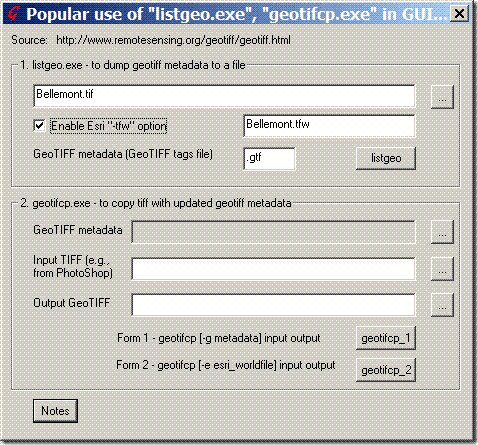
To extract the geodata, click the “…” button in the top section (marked “1. listgeo”), and select the GeoTiff file of interest. By default, the program will only create a .gtf file which contains the full geographic metadata for the GeoTiff, including georeferencing data, and coordinate system/datum data if present. If you want a plain worldfile written instead, make sure to check the “Enable Esri “-tfw” option” box. Press the “listgeo” button, and either a .gtf file or .tfw file will be created; in the example above, the file “”Bellemont.tfw” would be created.
To embed the .gtf data back into a TIF file, for example the original GeoTiff modified and saved in Photoshop so that the geodata has been stripped out, you would use the bottom section (“2. geotifcp”). Choose the .gtf file at the top, specify the input TIF file in the middle, and specify a name for the product GeoTiff file at the bottom. Then click the button marked geotifcp_1, and the original .gtf metadata will be embedded into the input TIF file to create a GeoTiff. The image data is unaffected by the embedding process; only the file header is modified.
A good utility, with some flaws:
1. Although there’s a button marked “geotifcp_2” that would seem to offer the option of embedding the .tfw worldfile data into the TIF, I can’t get it to work. You’ll have to use a program like GeoTiffExaminer to do that.
2. All the files need to be in a single folder.
3. There can’t be any spaces in the filename or directory path, which can be a pain in the neck.
I’m working on a clone of this utility that doesn’t have those drawbacks; it may be done soon.