8/29/09: Some have reported issues with the latest versions of both cgpsmapper (0098c) and MapSet Toolkit (1.62). If you have a problem with these, try using older versions of both programs, available at this link. Also, if you have problems with installing a mapset, try right-clicking on the program and choosing “Run As Administrator”; Windows crappy security system sometimes blocks programs from modifying the Windows registry, which MapSet Toolkit needs to do to install a mapset.
In the last post, OpenStreetMap data was converted to a Garmin .img map file, which can be directly uploaded to a Garmin GPS unit using SendMap or MapUpload software. But it’s more convenient to use the MapSource software that comes with most Garmin GPS units to do this, since you can preview the map data in that program, and create/upload multiple maps and mapsets easily. The best program I’ve found to do this is MapSet Toolkit; you’ll also need the map compiling program cgpsmapper, free for creating basic maps for personal use.
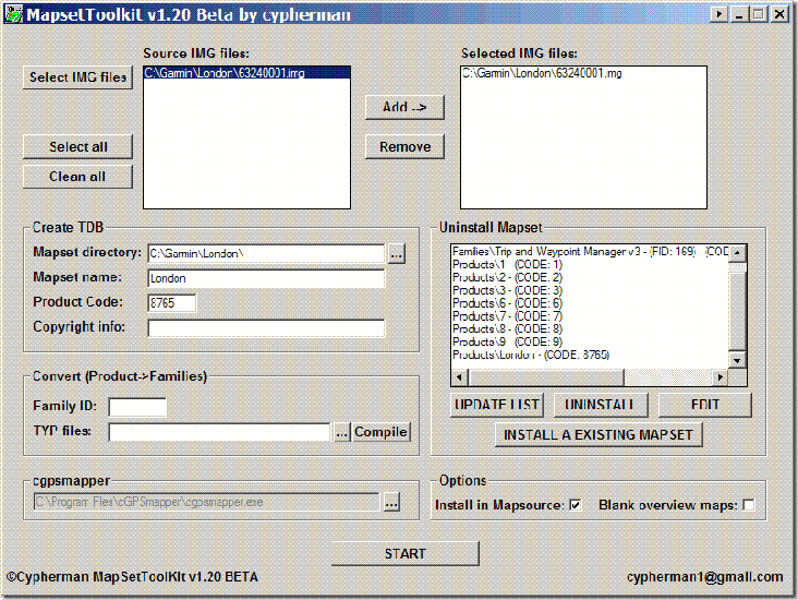
Using the process in the previous post, I downloaded some street data for London, and converted it to a Garmin .img file. I then used the following steps to add the .img file to MapSource:
1. Created a subdirectory in my C:\Garmin directory called “London”, and copied my “63240001.img” file there. Note: MapSet Toolkit will only recognize .img files with a numerical filename. If you rename the file with a non-numerical name, it won’t show up.
2. In Mapset Toolkit, chose that file with “Select IMG files”.
3. Highlighted that file, and “Add”ed it to the selected IMG files. You can add multiple .img files as part of a single set of files.
4.Chose the same directory that contained the .img file as the “Mapset directory” to be used
5. Assigned a name to the mapset, “London”
6. Chose a 4-digit “Product Code” number (“8765″ in this example); the only limitation is that it not conflict with any other product codes (which are displayed in the “Uninstall Mapset” box at the right).
7. You can enter copyright info if appropriate, but it’s not required here
8. At lower left, chose the directory where cgpsmapper.exe is located (usually the C:\Program Files\cGPSmapper directory), and selected the cgpsmapper.exe file
9. The “Convert (Product>Families)” section was left blank; more information about Family ID and TYP files is available in the cgpsmapper manual.
10. Checked the box marked “Install in MapSource”. Checking “Blank overview maps” will eliminate the map preview in MapSource. I’ve found that for some mapsets, leaving this box unchecked will result in a crash of cgpsmapper, and a failure of the installation; in that case, check the box and try again.
11. Clicked “Start”, and shortly thereafter got a message box saying “Convert termined” (sic).
12. In the “Uninstall Mapset” section, there’s now a new listing for the added map.
The program screen after all these operations looks like this:
![]()
If I now open Mapsource, the dropdown at the upper left has a selection for “London”; selecting it brings up the OpenStreetMap data:
![]()
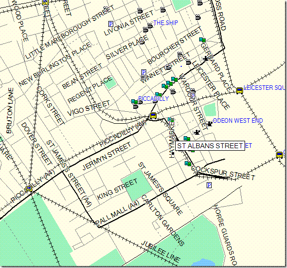
I can now select this dataset along with any others I might want, and upload it to my Garmin.
You can also use the “Uninstall Mapset” section to remove mapsets from MapSource as well. Occasionally, installing a mapset will cause problems with MapSource starting up; usually, uninstalling the mapset with MapSet Toolkit will fix that problem. You may have to run the program in “Administrator” mode to get this to work (see the comments below).
There’s more complete documentation available in PDF format at the MapSet Toolkit website. And a more complete, technical tutorial on doing this is available at the GPSFileDepot.
Addendum: There are two other programs floating around that can also add .img files to MapSource. M3 is available at MalsingMaps.com, where you can also find free Garmin maps for Borneo, Malaysia and Singapore; free registration required. However, I’ve found that if you install a MapSet using M3, other mapsets installed by either MapSet Toolkit or with the Garmin installer can disappear off of the dropdown menu (they come back after you uninstall the offending mapset). GPS Map Manager is better than M3, but MapSet Toolkit has a better interface and more capabilities.


Hello,
This is what scrolled in my “dos” box:
Unknown restriction – Too many tracks?
Something wrong? I followed your steps (in windows vista).
Thank you
Don’t know – I’ve never had this problem. Have you tried uploading it directly into your GPS via SendMap or MapUpload?
If you can email me the .img file, I might be able to take a look at it.
If you add an image covering the whole of Europe to Mapsource, is it possible then to upload only one country back to the GPS unit?
If the map covers all of Europe, then no – you can only upload the entire map of Europe.
My Garmin 60cx will not recognize the europe city navigator NT files on the pre-loaded micro Sd card. the files are .img on the card…but the card readed in the unit says there is no map data available (it does show 1.3 gb of other info). I also cannot get my mapsource to read the .img files either, even when following your suggestions. The card was purchased off ebay from what looked like a reputable dealer..it came in Garmin packaging and looked good. What am I missing? The Garming website indicated NT files would work with the 60cx…any thoughts?
The NT files should work with the Garmin, but I don’t have any experience with the City Navigator line. I do know that you have to enter a code to unlock these maps for use on one single unit – might that be your problem? If not, I’d suggest joining the Garmin 60Cx group on Yahoo:
http://groups.yahoo.com/group/Garmin_GPSMap_60Cx_60CSx/
and post your problem. You’ll be more likely to find an answer there than here.
For dutch viewers you could look here: http://www.gps-info.nl/custom_maps.html
Hey, I got through everything but when I opened Mapsource and “Switched Products” to my newly created source it shutdown. It wouldn’t restart the program again until I un-installed the file using MapSetTool. Any suggestions.
Michael
I had a similar problem in a different situation, and it was related to some problem with the preview maps. Try checking the box marked “Blank overview maps” in MapSet Toolkit, and see if that solves the problem. You won’t be able to see a preview of the map in MapSource, but that’s the breaks.
Thanks for the tip but it didn’t work in this situation. However it did made the process much quicker. A Bonus for a speedy transfer if your only goal is to get it to the GPS.
I’m not sure if I’m loading the finished file correctly in MapSource? Once I open MapSource I click on “View”, “Switch to Product” and then I select my new file that was generated. Am I missing a step?
Thanks For the Help.
Sounds right to me – don’t know what the problem is. You might try asking cypherman (the author of MapSet Toolkit); his email address is on the program.
It seems to have odd shaped segments, and all over the place it says “map created with http://www.cgsmapper.com/” How do I get rid of that?
It says “map created with …” because the original .img map was created with the free version of cgpsmapper.com, which stamps every map with that message. To remove that message, you have to create the map with the paid version. There’s nothing you can do with Mapset Toolkit to remove it.
And as for “odd-shaped segments”, that’s probably also the way the map was created, and there’s nothing Mapset Toolkit can do about that either.
Hi Leszek!
I have a Garmin Quest and I was wondering if there’s a way
to convert different MAP (not waypoints or pois) formats to MapSource .IMG
(from Destinator or anything else)
I couldn’t find any Garmin maps of Israel, only thing I found (MAPCENTER stuff) wasn’t detailed enough.
Any bit of info would be appreciated ;)
Thanks in advance!
I don’t believe there’s anything like that, to convert from Destinator to Garmin. Sorry.
Dug back into my mail archives, and found this link for a set of topo maps for Israel, if you’re interested:
http://michanisani.googlepages.com/israel_topo_2_meters
Hey again
Thanks for the quick reply.
And thanks for the link with the topo maps – very handy indeed.
The thing is – I’m looking for a detailed routable map, including city streets and addresses
and i found maps from different companies,Destinator was just one example.
There is Ozi etc etc.
I figured you can open some of those with MapEdit and save as .IMG.
Or am I wrong?
Anyway, question is if there’s a way to convert a routable map from one format to another,
keep the routable info etc.
Destinator was just an example.
Right now I have this one installed on the Quest :
http://mapcenter2.cgpsmapper.com/mapview.php?id=1555
(and I’ve installed it using tips from THIS post, so thanks for that as well!! ;))
but there’s no city street info except Tel Aviv… And no address info whatsoever.
Please enlighten me! ;)
Waiting for your reply.
P.S.
I’m totally new to the whole thing so sorry for any stupidity ;)
But “No questions – No knowledge”…
Do a search on this blog for JOSM, which can convert OpenStreetMap data to Garmin files; you may find some coverage for the areas you’re interested in. No address data or routing data, unfortunately.
I believe Garmin sells a MetroGuide disk for the Middle East; you might check that out.
I have a Garmin TOPOGB map, 583,184kB, supplied on microSD which I have copied to my HD with an 8-digit.img filename. I followed your instructions carefully, even using the same filename and product code. The result is a mapset of only 8kB, it loads into Mapsource but is obviously incomplete, just a blue rectangular-type shape.
Can you spot what I’m doing wrong please?
Such Garmin maps supplied in microSD format are typically locked to a single card to prevent piracy. So what you’re trying to do what won’t work. Sorry.
Well, I experimented with using the two programs to load img files to mapsource, and now mapsource wont work…tells me to reinstall, and I’ve done it all. I’ve uninstalled everything, rebooted and reinstalled and still i continue to get the same message. Must be something in the registry left by mapset toolkit and/or cgsmapper. I did use the beta version of mapset toolkit, so maybe that’s the issue. Any help out there??
This can happen if there’s an issue with creating a mapset with MapSet Toolkit, and MapSource can’t open it; it should be fixable using MapSet Toolkit. Open that program, and in the window at right labeled “Mapset installed”, you’ll see a list of installed mapsets. Start first by clicking on the “Check Registry” button, and see if it flags any of those mapsets as having an issue. If yes, select it and click “Uninstall”. If no mapsets are flagged as having a problem, then “Uninstall” them one by one, starting with any custom mapsets you may have created. Run MapSource each time to see if you’ve eliminated the problem mapset. I’m pretty sure this will fix the problem.
“It seems to have odd shaped segments”
I’ve had this problem as well, try re-loading the map with MapSet sometimes they clear up.
However, I am still having similar problems. The map was made by me, with lots of trial and error, but looks fine in both GPSmapper and GPSMapEdit. But when I load it to Mapsource the ocean fills into to the land in square formations. You can see the shoreline, roads, and everything else underneath but its all covered with blue ocean. The ocean fills up from the shoreline to the next quadrant on the interior and stops.
Any ideas?
“You can see the shoreline, roads, and everything else underneath but its all covered with blue ocean. The ocean fills up from the shoreline to the next quadrant on the interior and stops.
Any ideas?”
Nothing comes immediately to mind – sorry.
I couldn’t uninstall mapsets from my computer using MapsetToolkit. I tried using different versions and re-installing it, but each time I tried to uninstall a mapset I got an error saying the mapset couldn’t be removed.
A few minutes ago when I opened the program I right clicked and opened it as Administrator, and it worked perfectly, removing my unwanted mapsets. It’s not (to me) an obvious solution, since the software had no problems adding mapsets.
I’m using Windows Vista with the latest updates.
I use Mapset Toolkit all the time along with MapEdit. I’ve compiled a map of the mountain bike trails and bush tracks around my town. It’s much better than any map available.
Thanks to the clever people that write these programs, you do a great job.
i have this problem of layer 0 cannot be empty
can anybody help me on this
A “layer 0 cannot be empty” error is usually due to the original map file, not Mapset Toolkit.
Hi,
Very good documentation, thanks. I’ve downloaded from internet a gmapsupp.img, 111 MB, it is a TurkishTopo Map. With GPSDaemon, I cut it into pieces of 12 *.img files, then I used MapsetToolkit ver. 1.4 Beta by Cypherman, exactly how you’ve described as above. I tried first to get the *.tdb, *.img, *.reg files (without installing in mapsource), then with direct installing in Mapsource. In both cases (I didn’t understand the “blank overview maps” so I didn’t try it), I got the Error E032, by saying “could not find the TRE files”, and Layer 0 of he map cannot be empty. What really does this mean?
What should I do to make this map work in Mapsource?
Any help would be greatly appreciated..!
Thanks
gspot
I started with a Garmin Topo .img map of BC that I got on the internet with a size of 340,000 KB and when I converted it (following all steps as far as I could see) I ended up with a 5 KB .img map. The converted map loads perfectly into MapSource (no problem there) but except for one small area up North the map is a blank for the rest of British Columbia. Any suggestions?
Thanks, I really do appreciate your efforts,
I suspect the reason is that the map is too large in size for cgpsmapper to process. When MapSet Toolkit runs the file through cgpsmapper, it opens up a DOS window; watch the comments in that window, and see if an error message pops up. You might also try specifying blank overview maps; I’ve had problems before with cgpsmapper being unable to create an overview map for a large file. Finally, it’s possible that since these are Garmin’s proprietary commercial maps, they may not work.
Thanks for sharing your knowledge! I keep getting the “convert failed” error message when I try and convert my IMP files with mapset toolkit. I followed your instructions above exactly. After pressing start it seems to go so far then it opens cgpsmapper (a black rectangle window opens) briefly and I get quickly the convert failed error message and the whole process stops. Any ideas what may cause this? Seems to be a software issue but I downloaded the toolkit and cgpsmapper from your website links. Thanks!
Try checking the “Blank overview maps” box; I’ve found that for some large/complicated maps, cgpsmapper will crash if this box is unchecked, but work if it is checked.
Hello great guide, I really appreciate your effort, although i would like to ask a couple of things.
A)By installing maps in mapsource, can i them transfer them to any Garmin GPS unit? May that be an in-car handheld or Symbian Device?
B)Also what’s the signicance of the Family ID? IT seems that for newer versions of you cant mess with the product code, but you do have to input a family id different than the ones installed. What’s the significance of that?
Not owning a in-car device, I can’t say for sure, but I know that a number of people have been able to upload custom maps to their in-car Garmin units. I’m not sure what you mean by Symbian; AFAIK, there is no Garmin-branded unit running the Symbian OS.
This is also a guess, but the Family ID is likely needed for differentiating different mapsets in both MapSource and on your GPS unit.
Thank you for your answer. BTW is there a way to extract information from an .img an create a shapefile (.shp)?
Not directly, and certainly not for free. It should be possible to import a .img file into GPSMapEdit, save it as a .mp file, load it into Global Mapper, then export the vector data as a shapefile. Haven’t tried it, though, and I would first try to find comparable free vector data on the Web.
Thanx for the suggestion, just tried that, but my system run out of resources. How can i export a specific mapset from an .img and save it as its own .img? I found the mapset on mapsource but i cant see how i can save it as a different .img.
Short answer is to select the map segment you want in MapSource, then export it only to an external memory card; it will be the only map segment in the gmapsupp.img file created. You should then have a small-enough .img file to work with.
At some point in the future, I’ll post on some utilities that let you scan throughh the .img files on your computer, and identify them by name.
The Card solution is what i thought of as well. Does it have to be formated with Garmin file structure or can it be a plain SD card with arbitrary structure?
Well anyway, i’ll try it, thanx for the suggestion, looking forward to the future utilities, take care man!
No special formatting required; I believe it needs to be in FAT, but it should come pre-formatted that way. If it doesn’t already exist, a folder called “Garmin” will be created, and you’ll find the gmapsupp.img file in there.
Hi
Like Chris on 21st Feb I keep getting convert failed when I try to convert a .img file (austria) following instructions ok, cmd window opens then convert failed error. Does not matter if I try 1 img file or multiple img files, nor does it matter if I have the ‘Blank Overview’ box ticked or not.
I am using Vista home edition, I do have an old PC running xp pro and that worked ok I could convert all of the .img files ok, but using this new vista laptop, it’s a no go.
Are there any software conflicts with vista? do I need to keep my old xp machine going?
New to this GPS game and it all looks soooo complicated! books coming from amazon to ‘educate me’!
There’s no conflict with Vista – I’ve used these program successfully on Vista. I know that there have been some changes made recently to cgpsmapper, and that MapSet Toolkit needed to be modified to be fully compatible. There may still be some bugs derived from those modifications.
Further to my question re vista and any conflicts, thanks for the quick reply BTW. I have copied the folder containing the austrian .img files (plus any others when I unzipped the .rar)…I have also copied the mapset toolkit and cgpsmapper exe’s from my windows pc, onto my windows laptop. I ran the new mapset toolkit exe and img files copied onto my mapsource without any problems, I guess there must be some versions of mapset toolkit or cgpsmapper that are out of date???
I live in Azerbaijan and found a map that works great on a Nuvi200, but when I try to move the map to my 60CXs it says “can’t unlock map”. I have the unlock code but I’m not sure how to use it. Any ideas?? Thanks
Garmin maps are typically locked to a single unit, so you can’t transfer it to a second GPS.
hi, I own a nokia e71 device, I’m using garmin mobil XT, I downloaded from the net an .img file for Europe (Europe_NT_2010.1), when I load this file and i try to do a search in it, I get a message saying “not enough memory” or something like that. any ideas why? I tought I can somehow “cut” the .img file or load it trought map source, i tried lots of methods described all over the net, no success.
Sorry – I have no experience with either the Nokia or the Garmin Mobil XT program.
Hi,
I downloaded Sri Lanka Map (Sl_win32.exe) installer and installed it. It consist several maps combining in tile format. And I found one error in one map. So I edited it using GPSMapedit and saved in mp (polish) format. Then I converted it to img format using cgpsmapper-free in dos prompt comand menu. But now new map is not routable. it is just a image.
CGPSMapperFree does not support routing; you have to buy a far more expensive version of cgpsmapper to do that. I’m also not sure that GPSMapEdit can preserve routing information when it opens a .img file.
Then how can I edit maps. Sri Lanka doesn’t have maps with full information. I’m planning to make a map by my self. Pl help.
With limitations, you can get a map compiled with routing for free at http://mapcenter.cgpsmapper.com/. Other than that, your only option is to buy the version of cgpsmapper that supports routing, or live without it.
can any body help me to convert IMG or MP file to use with Nissan cefiro inbuilt navigation system
AFAIK, this isn’t possible.
Hi, I created map (94000021.img) using http://mapcenter.cgpsmapper.com/.
pl help me to upload this file to mapsource. when I use maptoolkit it again use sgpsmapper so map convert to unroutable.
not working :-(
I think I just got screwed by Garmin. I bought a nuvi 265wt last April and installed the software on my computer. I just install Windows 7 and are in the process of reinstalling all my software. I went to Garmin downloads and installed MapSource. I then went to My Garmin Products Manage Maps page and clicked on the “nüMaps Onetime™ City Navigator® North America NT 2010.10″ Download Again link and it said it expired. So then I ran MapSource and went to Transfer menu selected “Receive From Device” to get the built-in map “City Navigator North America NT 2010.10″ off my unit and it did not copy to my computer even though I had the Maps check box selected. I called Garmin support and after 30 minutes of waiting they said I’m out of luck. You can not move, copy, restore or reload the built-in map the my Garmin nuvi265wt comes with. I don’t think that is very nice!!
I have since restored my OS from a backup and I’m looking for help to save and restore my built-in map on to the new Window 7 OS.
Don’t have any help to offer here, I’m afraid. Garmin *should* give you a break on this, I think.
I’ve made several versions of a map in Mapset following your very clear instructions. Maps all appear in Mapsource v6.15.6, and I can upload to my GPSMap 60Cx (latest updates). In the GPS, the Map menu doesnt show the uploaded maps, just a blank window with an empty box where one expects to see the names of uploaded files, and the GPS then freezes. I’ve reformated the microSD, reinstalled Mapset and Mapsource. I can successfully upload other Garmin topo maps and they are recognized, just a problem with maps that I create. I tried different combinations of Draw priorities, Transparency and Blank overview. The IMG all show up fine in the registry and open ok in Mapsource. Any ideas please?
Just a quick comment to say thanks for the guide its very good. But i would like to note that i pulled my hair out trying to do this on my desktop which runs VISTA, however when i used my laptop which runs XP it worked 1st time no problem, so all VISTA users please be aware that if it doesnt work try it on an XP machine if you have access to one!!!
I am getting “Error PE11:Preview map has to be less detail than any IMG file in the mapset. Change level definition in the [MAP] section to a less detailed.”
Where do I change the definition & what size?
I have the same problem as Chris:
“Error PE11:Preview map has to be less detail than any IMG file in the mapset. Change level definition in the [MAP] section to a less detailed.”
Same question: where do I set this?
I am using the ‘latest’ cGPSmapper, 0.98g.
Thanks!
When cgpsmapper went from version 0096c to 0098c, some compatibility issues arose between it and MapSet Toolkit, and that may be part of the problem. I’d contact the author of MapSet Toolkit directly to ask him if he knows the source of this problem.
I avoid these problems by sticking with the older versions of MapSet Toolkit (1.50) and cgpsmapper (0096c); you can download them from links on this page:
http://moagu.com/?page_id=8
Leszek,
Thank you so much!
That was the problem, indeed!
The older tools worked!
Cheers.
Hi.. I’m actually new to all of this stuff of GIS. So I would really appreaciate if you could delp me.
I would like to do a GIS system using either MApserver/OpenLayer or MApGuideOS/OpenLayer and I am searching for a mapfile of my country. I already asked for it on Navteq and DS Solutions but the cost is really expensive (USD$22,000 a year) so searching through the internet I found that I can download Destinator maps which comes with streets and covers all of my country cities and roads.
I would like to know if there is some way to convert from that format (PN I think it is) to shapefile so I can use it at my MapServer.
Thanks in advanced
Hi,
Thanks a lot for your very clear instructions. I was sucessfull to get a french topo guide on my PC with Mapsource. However, when I try to download the map to my GPS (Garmin etrex) I only get the overall map, not the detailled topo map. My original Belgian map is then also reduced to the overall data. (Restorable from my backup). Where should I further investigate ? Thanks
Back to my problem of lack of details in maps transfered to the GPS. It is SOLVED.
I just did not zoom enough. Sorry.
It means however that your instruction is 100% successfull. Thanks again. Jean
Hi Everyone
First of all thanks for all the help provided in this web and it’s forum!
But I have a big problem!!!!
I bought a e-trex vista HCx, I installed the Trip and waypoint manager from the original CD (I also installed the Mapsource from the garmin website, because I thought was more updated.)
I tryed to convert img files into files compatible with mapsource, I went through all the steps installing cgpsmapping and also mapsetoolkit (the older versions of MapSet Toolkit (1.50) and cgpsmapper (0096c), I went through all the steps.
After point 11 “convert termined” didn’t appeared so I went back to point 10 and I check the box “blank overview maps” so I clicked “start” and “convert termined” show up. Then I went straight to open Mapsource, and check If I succeded (to see if the new map was recognized!), and when I started the Mapsource, an error appeared, so I am not able to start mapsource again!!!
I tryed everything, I disintalled it, installed it again and it didn’t work, so I removed all the other programs such as mapsetoolkit, cgpsmapping etc, and it didn`t work!!! there’s no way to make mapsource working even though installing the original box DVD one!!!!
The error that appears sais: there is a problem with the mapsource installation, install mapsource again and restart it!!!
Can someone help me please!!!
Thanks in advance
keep on going!!!
Run MapSet Toolkit, and use it to delete the mapset you tried to install. Sometimes for some unknown reason, a mapset registry key installs even when the mapset doesn’t; when MapSource starts up, it looks for the mapset, doesn’t find it, and crashes as a result. Bad programming IMHO. Anyway, uninstalling MapSource doesn’t clean up the registry keys, but manually removing the problematical mapset with Mapset Toolkit should fix your problem.
Hi Leszek (or should I say Doc??)
I can only say you are great!!
Your answer fixed the problem and Mapset is working again, now my question is what did I do wrong???!!!
I am afraid that if I try again, the same problem will happen!!
I will try with another map… and maybe it works!!!
Is there any web where I can get maps that come already with the format compatible with Mapsource so I do not have to go through all the mentioned steps?
I found a web called “http://www.proyectomapear.com.ar/” which is from Argentina, and their maps are already compatible with mapsource, but all the maps are from South America and I need from Europe, I am trying to convert the maps from “http://gpsmapsearch.com/?l=es” wich are .img files into files compatible with mapsource, but man, is not easy!!!!
I will let you know!!!
I have to say that even though I am bad with computers, and I am not a very smart person, the way you explained how to go through all the steps is just amazing and super understandable!!!
Once again thanks for sharing your knowledge and loosing time with persons like me and our problems!!
Big hug from the pyrenees!!!
JEM
Hi Leszek!!
I managed to convert the files!!!!!!!, many thanks!!!!!,
But now I have a new problem, after converting one .img file into a
one compatible with mapsource, when I open mapsource it appeared the
error which says
Error information:
App: Mapsource
At: 11:11:2009 12:47:08 (UTC)
Os: Windows Vista Service Pack !
Processor: x86 Processor level:6, Processors:2, Model:15, Stepping:13, RAM: 2097151
TDB_REGIONDIR.CPP-164-6.13.7.0
Product ID: 4
Region ID: 0
It asked me to sent a report to Garmin, but I do not want to!!! (who knows, maybe they will remove the warranty, so I do not want them to know I am operating with other maps!!
I tried to do what you told me for the previous error(when Mapsource also got blocked!), but the
mapsettoolkit does not allow me to remove the last converted file
(which provoqued the error) because the ones converted before, do not
created any problem and I was able to open Mapsource!!
I select the mapset, I click in uninstall, and afterwards when it asked me if I want to remove Mapset, I click yes and says “! Cannot remove mapset” what can I do??
Many many many many thanks in advance
JEM