Newer Garmin GPS units support the upload of sets of POIs, containing both position data and descriptions of the Points Of Interest. The KMLCSV Converter is a Java application that lets you convert placemarks created in Google Earth and saved as a KML file into a CSV (Comma-Separated Values) file compatible with Garmin’s POI Loader; this CSV would also be compatible with most spreadsheet programs as well. The process is straightforward:
1. Create placemarks in Google Earth using the “Add Placemark” tool, search, or other means.
2. Add a description to the placemark.
3. Drag all the placemarks you want to save into a single folder.
4. Save the folder as a KML file
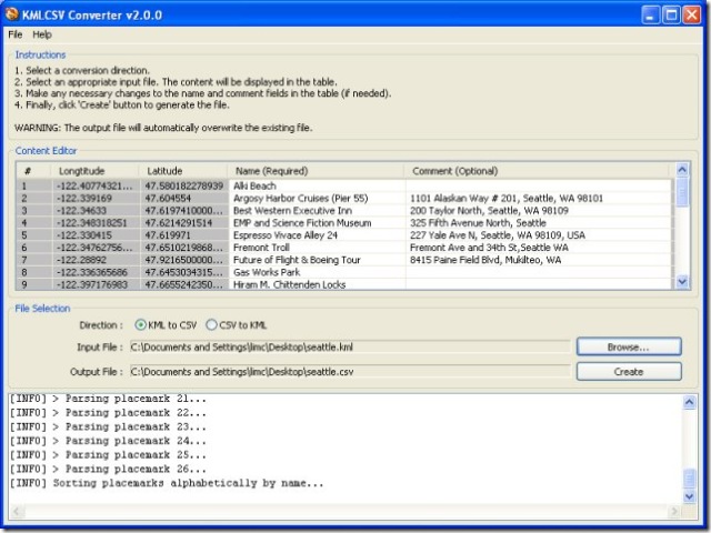
5. Convert it to a CSV file with the KMLCSV Converter Program (screenshot from website)
6. Upload the CSV POI file to your Garmin with the POI Loader program, or into your spreadsheet as a standard CSV file.
There’s a short PDF tutorial file that covers these steps quite clearly with screenshots.
You can also convert CSV files, either POI files or spreadsheet files created by yourself or someone else, into KML files for viewing in Google Earth; a search for “Garmin POI” files on the web will bring up links to many sources, both free and paid. But I prefer the program csv2kml for that purpose.


Why won’t it work with Google Maps?
If I export and download to my hard drive a KML file from My Saved Places in Google Maps, KMLCSV Converter cannot find any points to read in the KML file.
Don’t know. Try opening the KML file in Google Earth, checking to see if it looks OK, then save it as a new KML file from Google Earth and see if it works.
These descriptions are over my head. I wondered if you could tell me which program lets me put in an excel file containing only addresses and names (USA and Europe) and then imports them into Google Earth. The reason i want to do this is so I can then import them as poi’s into Tomtom Navigation 5 on my pda. I also looked at the program which lets one use Google Earth offline from an Egyptian programmer but couldn’t make heads or tails out of it. Is there a simple way of doing that. Any info appreciated. Thanks
For US addresses, take a look at some of these options:
https://freegeographytools.com/2007/us-address-geocoding-for-google-earth
Some of them may work for European addresses, but I’m not sure about that.