For many Garmin GPS units, including most handheld models, the only mapsets that currently supports turn-by-turn routing are the City Navigator products, like the $75 City Navigator North America. These are available in two formats, both of which tie the maps to a single GPS unit. In the microSD card format, you install the card into the GPS unit, which means you can only use it in one unit at a time, and you can’t use it in conjunction with other mapsets; in fact, if you upload more maps to the card, you’ll erase the City Navigator maps! In DVD format, you can upload the City Navigator maps along with those from other mapsets, but the DVD maps are tied to a single GPS unit based on its serial number and a registration code – you can’t use them on any other unit, nor can you transfer them to a new unit you might buy to replace the old one.
mkgmap is a program that converts Open Street Map (OSM) data into Garmin-compatible maps, and it has recently added support for turn-by-turn routing. The Free routable maps website offers a convenient way to obtain these routable maps in several different formats.
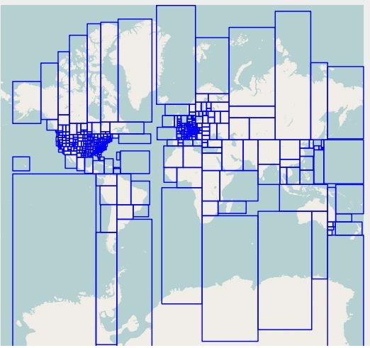
Current map coverage is for the same areas covered by OSM, i.e. most of the world:

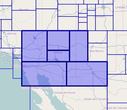
A full-country option for downloading maps is currently disabled, so you have to select map tiles individually. Check the box at the top next to “enable manual selection”, zoom/drag the interactive map to your area of interest, then click on the tiles you want:

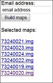
As you click on the map tiles, hyperlinks for each of them appear at the left, and if you want you can click on those links to download them directly. But there’s also a space to enter your email; if you do, and click the “Build Maps” option, the site will combine the map tiles into several different formats, and then email you links where you can download files that contain these formats:

The MapSource installer is the most convenient, but has one serious flaw: it uses the same mapset name (“OSM World Routable”) for any mapset you install. So if you install one, then install a second, the second will overwrite the first. You can get around this by installing the individual map tiles as a mapset with a name of your choice using MapSet Toolkit.
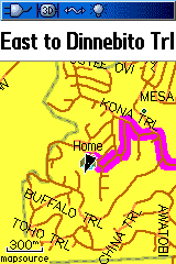
I installed routable maps for my area into my Garmin 60Cx, which supports turn-by-turn routing. Note: Some handheld Garmin units do not have turn-by-turn routing (check your manual), but on those you will still be able to see the maps. I tested it on a few local trips, and the routing feature does work:

However, the maps do have some limitations, especially when compared to Garmin’s City Navigator products:
– OSM data is a worldwide communal effort to create freely-distributable maps for the world. Some areas have excellent road coverage, like the US; others may not. For me, finding a destination by street address seemed to work quite well.
– OSM data includes some points of interest, like schools and restaurants, and these can be searched for on your Garmin. But coverage on these points of interest is very spotty; for my area, only a handful of the 300-odd restaurants in my city were included. As the OSM maps mature, this will likely improve, but they still have a long way to go. If having a full set of points of interest is important to you, these maps are currently too immature, and you’d be better off with the Garmin City Navigator maps.
– The routing will get you to your destination, but the choice of route is sometimes … eclectic. Commercial GPS units have this problem sometimes as well, but my impression is that the OSM maps are a bit quirkier in this regard. As the OSM data improves, and as mkgmap improves its routing capabilities, this may also get better with time.
Still, for the price, i.e. free, it’s pretty good for street maps and routing, at least for my area. Links to additional sources of OSM-based Garmin maps, routable and not, are available on this web page.
HT to Robert.


This is honestly one of the coolest things to come around in a long time. Thanks for the link!!
Just thought I’d send you another link in case you haven’t come across it yet. It is in the same vein as “free” and “OSM”.
http://www.maposmatic.org/
It produces some pretty nice printable maps of OSM data along with an index page, albeit with all the caveats of OSM data. Additionally, their render doesn’t seem to support non-western character sets yet. The regular OSM renderers do though, so I guess it is just a matter of time.
Thanks again for your website.
Robert
P.S. Is that “website” box for a personal website, or just a website to be submitted? MapOSMatic is not mine.
Just another quick note before I am off. The MapOSMatic site plans on adding LatLon lines to the maps, so I guess that would make it easier to use with G-Raster for people who want raster imagery (sometimes better landuse depiction) to go with OSM vector data.
Cheers.
Hi
I have a question: I can generate maps – ok, but when I put the maps on my Garmin Nüvi (car gps) the GPS always asks me for a country of the routing target first. The problem simly is: No countries seem to be embedded in the maps. Or are they? If so: Where?? How can I use the OSM routable maps for my car GPS?
Olaf
—
* together for better software *
* http://www.team-noehring.de *
Hi
well, I found an (not THE) answer to my own question:
http://forum.openstreetmap.org/viewtopic.php?id=2625
Olaf
—
* together for better software *
* http://www.team-noehring.de *
Hi
I downloaded the map on my oregon, but have a big problem. The streetnames ain’t shown and when I try to navigate on roads, I only get the message that there ain’t any streets nearby to navigate on. It’s the same problem on all my cards, not only this one. Any one who can help me?????
You might try downloading it again – the service re-compiles the map every time you request it, so it might just be a compile glitch the first time. Other than that, I don’t know – it worked fine for me.